Water profile of Laos
Contents
Geography and Population
The Lao People's Democratic Republic (Lao PDR) is a landlocked country in the Indochina peninsula with a total area of 236,800 square kilometers (km2). The country stretches more than 1,700 kilometers (km) along a north-south axis. Some 80 percent of the country’s area consists of hills and mountains. The highest point is the Phu Bia at 2,820 meters (m) above sea level. Administratively, Lao PDR is divided into 17 provinces plus the municipality of the capital, Vientiane.
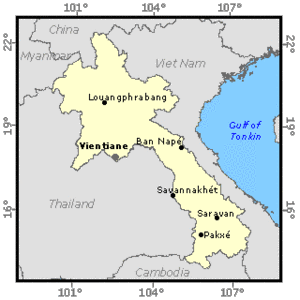 Map of Laos. (Source: FAO)
 The cultivable area is estimated at 2 million ha, consisting of narrow valleys and the flood-prone plain of the Mekong River and its tributaries. The cultivated land area fluctuates between 650,000 and 750,000 hectares (ha) (720,000 ha in 1994, of which 600,000 ha of rice cultivated during the wet season). In 1984, about 23 percent of the cultivated area was managed by cooperatives. However, following the New Economic Mechanism implemented in 1986, the cooperatives were dissolved, and all the cultivated area is now privately managed.
The total population was estimated at 5.04 million inhabitants in 1996 (78 percent rural), with an annual growth rate of 2.6 percent. The average population density is 21 inhabitants/km2 , which is one of the lowest rates in southeast Asia. It ranges from 8 inhabitants/km2 in the southern provinces of Attapeu and Sekong near the Vietnamese border up to 30 inhabitants/km2 in Savannakhet or Champasack provinces, and 150 inhabitants/km2 in Vientiane municipality.
The agriculture sector accounted for 56 percent of the Gross Domestic Product GDP in 1994, and employed nearly 85 percent of the work force. Agriculture's contribution to export earnings is officially recorded at 40 percent (mainly timber and wood products, and coffee) but rises to 55 percent if unofficial exports of livestock and logs are included. Hydroelectricity sold to Thailand represented 60 percent of total export earnings in 1990.
Climate and Water Resources
Climate
Climate is typically tropical with a rainy season from mid-April to mid-October dominated by the humid southwest monsoon. The average rainfall is 1,600 millimeters (mm) but ranges from 1,300 mm in the northern valleys to over 3,700 mm at high elevations in the south. About 75 percent of the rainfall occurs during the rainy season. The water level in the Mekong River may fluctuate by up to 20 m between wet and dry seasons.
River Basins and International Rivers
The Mekong River is the main river in Lao PDR. Forming the border with Thailand, in Lao PDR it flows for about 1,860 km, of which almost every part is navigable. The Mekong River basin covers 90 percent of the total area of the country. About 25 percent of the Mekong River basin is located in Lao PDR, which contributes 35 percent of the Mekong’s total flow. The main tributaries of the Mekong River in Lao PDR are, from north to south, the Nam Où (11 percent of the area of the country), Nam Ngun (6 percent), Nam Theun (7 percent), Xe Banghieng (9 percent), and Xe Kong (10 percent). The Lao part of the Mekong River basin is divided into 32 sub-basins for planning purposes.
Lao PDR has been a member of the Mekong River Commission since its inception in 1957. A new agreement was signed in April 1995 between the four riparian countries of the lower Mekong, regarding all aspects of Mekong River basin development (navigation, irrigation, hydropower, flood control, fisheries, timber floating, recreation, and tourism).
In addition to the Mekong, six small river basins drain from Lao PDR towards Vietnam: the Tale, Nam Ma, Nam Mat and Nam Xa rivers, and two others, the Nam Luang and Nam Mô, meet in Viet Nam before reaching the sea.
Water Resources
A significant part of the water resources of Lao PDR come from neighbouring countries, namely 73.63 cubic kilometers per year (km3/year) from China and 17.6 km3/year from Myanmar while the outflow from Lao PDR to other countries consists mainly of the Mekong River to Cambodia (324.45 km3/year at Paksé) and small [[river]s], the Ca and Ma rivers (9.1 km3/year), to Vietnam.
The internal surface water resources have been estimated as the difference between the outflow and the inflow to the country, i.e. 190.42 km3/year, while groundwater resources are roughly estimated at 38 km3/year, most forming the base flow of the [[river]s]. The total renewable water resources are therefore estimated at 333.5 km3/year.
Dams and Hydropower
Lao PDR has great potential for hydropower development. Considering only the tributaries of the Mekong River, 18,000 megawatts (MW) could be generated according to recent estimations. The largest hydropower plant, Nam Ngun located north of Vientiane, has a total capacity of 150 MW and a storage capacity of 7.01 km3. Two other dams in the south (Xeset and Selabam) have a total storage capacity of 0.3 km3 and can generate 50 MW. Hydropower accounts for 95 percent of electricity generation in Lao PDR.
Two dams are under construction, mainly for power production. In 1998, the two projects (Nam Theun Hinboun in central Lao PDR and Houay Ho in the south) will have an installed capacity of 210 and 143 MW and a storage capacity of 0.02 and 0.52 km3 respectively. The Government has also launched feasibility studies for 21 other hydropower projects throughout the country. All these projects are located on tributaries of the Mekong River. Projects on the main stream have been planned for many years (more than 40 years in the case of the Pa Mong dam) but have not yet been implemented. The installed capacity will greatly exceed local demand and is mainly destined for export to neighboring countries.
Water Withdrawal
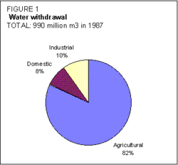 Figure 1. Water withdrawal. (Source: FAO)
 The total water withdrawal was estimated at 0.99 km3 in 1987, of which 82 percent for agricultural purposes (Figure 1). There is no wastewater treatment in Lao PDR.
Irrigation and Drainage Development
A rough estimate of the irrigation potential for Lao PDR is 600,000 ha.
The total area equipped for irrigation was estimated at 155,394 ha in 1995. This area covers 123,917 ha designed for supplementary irrigation during the wet season and 31,477 ha designed for dry season irrigation and also used for supplementary irrigation during the wet season. While wet season irrigation is common throughout the country, dry season irrigation is mainly concentrated near the major cities: Vientiane (59 percent of total dry season irrigated areas), Savannakhet (11 percent) and Luang Prabang (6 percent). Although irrigation by groundwater is considered as a possible form of irrigation development, it does not exceed 100 ha at present. River diversion is the main source of water for irrigated schemes, particularly the smaller ones (Figure 2). All areas are irrigated by surface irrigation; sprinkler and micro-irrigation are not used in Lao PDR.
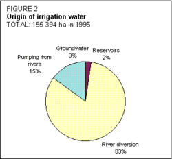 Figure 2. Origin of irrigation water (Source: FAO)
 In the dry season, the actual irrigated area is far below its maximum as only 43 percent of the equipped area of 31,477 ha is actually irrigated. Pumping costs and market access difficulties for other cash crops, particularly in the north, do not make paddy cultivation attractive in the dry season. Nevertheless, it has been noted that after poor yields during rainy seasons, the irrigated area in the dry season was higher than the average in order to compensate for the low production of the previous season. During the wet season, the areas actually irrigated are 149,272 ha, or 96 percent of the total equipped area.
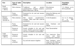 Table 1. Typology of irrigation schemes. (Source: FAO)
 A typology of irrigation schemes is presented in the Table 1.
The large-scale and several medium-scale schemes are generally underexploited and face operations and maintence (O&M) difficulties. Government policy is to transfer management responsibilities to users, but farmers lack management skills as they have never been involved in scheme and water management.
Another classification of irrigated schemes is by type of management. Some schemes are wholly managed by the farmers themselves, while others receive the assistance of irrigation department services. Pump schemes belong to the latter. More than 80 percent of the gravity irrigated schemes are managed by the farmers themselves.
In the north, beaver dams are in use, but they are generally flushed away two or three times a year. These highly maintenance intensive structures are being gradually replaced (generally with international assistance) by more permanent weirs of mortared rock or reinforced concrete.
Drainage and flood protection structures have generally been taken into consideration in the irrigated schemes design plan but have often not been developed because of budget restrictions.
The main irrigated crop is rice. About 11,000 ha were cultivated with paddy during the 1994 dry season, and 149,272 ha actually irrigated in the 1994 wet season. Other irrigated crops are vegetables in the dry season near urban [[market]s] (Vientiane, Savannakhet, Saravane, and Champassak). Although no precise data are available, the total figure has been estimated at 2,420 ha.
Non-irrigated paddy was estimated at 450,000 ha in 1994, of which 49 percent was upland rice (shifting cultivation), and 51 percent was lowland flooded rice in the alluvial plains.
The average cost of small-scale weir scheme development is about US$200-400/ha. Large schemes implemented by the Government, sometimes with external aid, cost between US$3,500 and 7,000/ha.
Institutional Environment
The Water Supply Company is responsible for the preparation of programs and the implementation of all works connected to drinking water production and distribution. The Ministry of Health is in charge of water supply to rural [[population]s], while urban water supply is under the responsibility of the Urban Planning Division within the Ministry of Communications, Transports, Posts, and Constructions.
The Ministry of Agriculture and Forestry and the provincial authorities are jointly responsible for investigation and implementation of maintenance, repair and construction works for agricultural hydraulics, land development, dikes and flood protection structures. Two departments are involved:
- the Department of Hydrology and Meteorology, which is responsible for collecting and analysing climatic and hydrological data, and for flood forecasting;
- the Department of Irrigation, which provides central planning and coordination of irrigation development throughout the country. It also offers advice to provincial administrations on matters concerning irrigation services. It consists of the following divisions: technical management; operation and maintenance; and planning and cooperation. The Study Survey and Design Centre, under this department, has the capacity to survey and design 10,000 ha/year, and supervise its realization in cooperation with provincial administrations. The function of the Irrigation Section of each province is to provide services in the survey, design and supervision of construction, while a construction enterprise undertakes the implementation of projects.
An initiative called the "Strengthening and restructuring irrigation development project" (SRIDP) is being implemented. It aims to develop and provide assistance in implementing strategies in the irrigation subsector. Another project called "Farmer irrigated agriculture training" (FIAT) aims to train technicians and farmers in irrigation scheme design and management.
The Ministry of Communications, Transports, Posts, and Constructions is in charge of improving inland waterways and facilitating navigation on the Mekong River and its tributaries. There is no legislation governing the use of water for inland navigation.
Together with the Société d'électricité du Laos, the Office of Hydropower within the Ministry of Industry and Handicrafts is responsible for the maintenance of hydropower dams and power generation.
In 1991, a constitution was adopted which enshrined the principle that land belongs to the State, but that individuals are guaranteed rights to use it. Land titles have not yet been distributed, but the principle has been accepted and a land market has been developing rapidly since 1992. A land registry survey is planned for the irrigated areas. A water law was drafted in 1995.
Trends in Water Resources Management
In terms of water supply, the Government's long-term objective is to provide 80 percent coverage to the population by 2015. Although each province has benefited from an urban water supply program financed by international aid (from Japan, Germany, the Asian Development Bank, the World Bank and the European Union), rural water supply programs have not been numerous. The national water supply and environmental health program, supported by the Swedish International Development Agency (SIDA) through the UNDP-World Bank Water and Sanitation Programme, aims to improve rural water supply and sanitation. Water supply activities still remain concentrated in and around major towns along the Mekong River.
A master plan for comprehensive water resources development is in preparation for two Mekong tributaries: the Nam Ngun and Nam Theun rivers.
Seven programs have received top priority from the Government for the coming years. One deals with infrastructure development: rural roads and the electricity network will be developed, medium and large-scale hydropower dams will be constructed, and small-scale irrigation systems will be designed and constructed to increase dry season agricultural production.
Considerable investments have already been made in the last 20 years in irrigation development. Despite these efforts, only 13,500 ha are irrigated in the dry season. Although the returns on public investment in irrigation were low to negative in 1993, the irrigation sector still receives attention from donors. About 38 percent of all planned donor support in agriculture for the period 1994-2000 is for new irrigation projects.
The Government has recognized the problems facing the country and the strategy in the irrigation sector has been redefined. The new water law is based on:
- improving the planning of new irrigation projects so that they are based on the needs of the farmers and are driven and managed by them. WUGs are being set up, and the new water law should provide a legal framework for these associations. The objectives of the Irrigation Department are now: (i) to develop irrigation for all lowland paddy fields in the wet season as long as farmers are interested and group themselves in WUGs; and (ii) to develop dry season irrigation.
- making the existing schemes economically viable and self-sustaining, by: (i) helping farmers to establish WUGs; (ii) training farmers in irrigation management; (iii) encouraging farmers to introduce O&M cost recovery systems; and (iv) developing [[market]ing] infrastructures.
Under the New Economic Mechanism, policy on irrigated agriculture emphasizes the role of [[market]s] and prices as allocation mechanisms and a shift to cost recovery for services and facilities provided by government to farmers. Electricity and operating costs have been paid directly by farmers since 1992. secondary and tertiary canals are the responsibility of farmers for all maintenance matters.
Until 1994, the Irrigation Department was responsible for the O&M of weirs, dams, pumps, and primary canals. It is planned that these responsibilities will be handed over to WUGs or WUAs. However, in many cases, O&M are still carried out by the Irrigation Department or its provincial services.
A pragmatic approach has been adopted for a transitional period while the establishment of WUGs is encouraged and farmers are trained in irrigation management, irrigation scheduling, and O&M. It is expected that, eventually, each WUG will be able to define the water charge needed to sustain the irrigation scheme.
Further Reading
- Charoenwatana, T. 1989. Lao PDR: agroecosystems. Paper presented at the exploratory workshop on Lao agroecosystems held in Vientiane 31-7 / 3-8 1989, organized by the Southeast Asia Universities Agroecosystems network and East West Environment and Policy Institute, Khon Khaen, Thailand.
- ESCAP. 1995. Guidebook to the water resources, use and management in Asia and the Pacific. Volume I: water resources and water use. New York. ISBN: 9211197058
- FAO. 1993. Lao PDR, medium-term integrated rice production programme. TCP/LAO/2358, Vientiane.
- FAO. 1995. Evaluation of farmers irrigated agriculture project activities and constraints. Report prepared by M. Smith. Rome.
- FAO. 1995. Lao PDR, assessment of the impact of the floods on the agricultural sector and emergency measures to be taken. Report prepared by L. Thomas, Special Relief Operations Service. Rome.
- Ounthouang, T. 1995. Integrated water resources management in the Lao PDR. Paper presented at a workshop on integrated water resources management in Vientiane, 10-13 October 1995, coorganized by the Mekong River Commission Secretariat, the Lao National Mekong Committee, and the Centre for Research and Environmental Studies, Australian University. Vientiane.
- World Bank. 1995. Lao PDR, agricultural sector memorandum, an agricultural sector strategy. Report 13675-LA. Washington, D.C.
- Water Profile of Laos, Food and Agriculture Organization.
- World Factbook: Laos, Central Intelligence Agency.
| Disclaimer: This article is taken wholly from, or contains information that was originally published by, the Food and Agriculture Organization. Topic editors and authors for the Encyclopedia of Earth may have edited its content or added new information. The use of information from the Food and Agriculture Organization should not be construed as support for or endorsement by that organization for any new information added by EoE personnel, or for any editing of the original content. |