Water profile of Armenia
Contents
Geography and population
With a total area of 29 800 km2, Armenia (40°00' North, 45°00' East) is the smallest country of the Former Soviet Union (FSU). It is a landlocked country, located south of the Caucasus mountains. It is bordered in the north by Georgia, in the east by Azerbaijan, in the south by Iran and in the west by Turkey. A part of Azerbaijan is located to the southwest of Armenia and bordered by Turkey, Armenia and Iran. Until 1995, the country was divided into 37 districts. It is now divided into ten marzes (provinces) plus the Yerevan municipality, which is the capital of Armenia.
The average altitude of the country is 1,800 meters (m) above sea level, ranging from 380 to 4,090 m (Mount Aragat). More than 90% of the country lies above 1,000 m and 72% above 1,500 m. The landform in the center and north of the country comprises rocky high mountain ranges separating narrow fertile valleys. Towards the south are the broad, flat and fertile Ararat valleys along the left bank of the Araks River forming the border with Turkey. To the west and north of Mount Aragat, and around Lake Sevan in the east, the landform is generally rolling with rocky outcrops. In the southeast, a few small irregular-shaped valleys are surrounded by high mountain ranges.
Agriculture is greatly influenced by the topography, most of the cultivated land lying within an altitude range of 600-2,500 m. The cultivable area is estimated at almost 1.4 million hectares (ha), which is 47% of the total area of the country. In 1995, the cultivated area was estimated at 408,147 ha, of which 346,413 ha were occupied by annual crops and 61,734 ha by permanent crops.
Official figures on the progress of privatization indicate that by the end of 1993 about 87% of the land so earmarked had already been privatized. Individual private farms have become the dominant form of farming. At the end of 1994, there were nearly 300,000 private farms with holdings averaging less than 2 ha.
The total population is about 3.64 million (1996), of which 31% is rural. The average population density is 122 inhabitants/km2. In 1994, agriculture employed 15% of the economically active population and its contribution to gross domestic product (GDP) was 41%.
Climate and water resources
Climate
Depending on altitude, Armenia enjoys a variety of climatic conditions. The Ararat valley is characterized by hot dry summers and cold dry winters, with a total annual precipitation of 200-300 mm. Precipitation increases towards the mountains, up to 1,000 mm on Mount Aragat. It is highest from April to June and lowest from December to February. The average precipitation for the country is estimated at 526 mm/year.
River basins and water resources
Armenia lies wholly within the Kür (Kura) River basin. The basins of the tributaries flowing directly to the Kür River cover less than 25% of the country in the northeast. Here the outflow to Georgia through the Debet River is estimated at about 0.890 km3/year and the outflow to Azerbaijan at about 0.555 km3/year. The Araks River, which forms the border between Turkey and Armenia and further downstream between Iran and Armenia, flows into Azerbaijan where it joins the Kür River about 150 km before its mouth at the Caspian Sea. The total outflow to Azerbaijan through the tributaries of the Araks River (Arpa, Vorotan, Vokhchi) is estimated at about 1.791 km3/year.
The renewable surface water resources (RSWR) originating inside the country are estimated at 6.271 km3/year and the internal renewable groundwater resources at 4.200 km3/year. The overlap between surface water and groundwater is estimated at 1.400 km3/year. This results in 9.071 km3 of total annual internal renewable water resources (IRWR). The border flow of the Araks River between Turkey and Armenia is estimated at 1.929 km3/year; that of the Akhuryan River, also between Turkey and Armenia, at 0.986 km3/year. Half of these flows, or 1.458 km3/year, is accounted for in Armenia's water balance. The total actual renewable water resources (ARWR) are thus estimated at 10.529 km3/year, of which 7.729 km3 is surface water, 4.200 km3 is groundwater, and 1.400 km3 overlap.
Lakes and dams
Lake Sevan
The largest lake in Armenia is Lake Sevan, located in the east of the country. It lies at 1,925 meters (m) above sea level, which makes it a strategic source of energy and irrigation water. The level of the lake, originally with a surface area of about 1,414 km2 and 58 km3 of stored water, has fallen since the 1930s due to the lake's increasing use for irrigation, hydropower and domestic water supply. By 1972, its level had fallen by almost 19 m and its surface area had been reduced to 1,250 km2. Since 1972, unforeseen changes in the lake's ecology (loss of fish population), water quality (entrance of sewage) and microclimate (freezing of the lake in winter) have occurred. The government attempted to raise the water level of the lake again through reduced water take-off (for example, no water use for hydropower production during winter since 1978); the construction of pumping stations; and inter-basin water transfer—from the Arpa and Vorotan rivers, through the Arpa-Sevan link (constructed) and the Vorotan-Arpa link (under construction), and from the Debet River, through the Debet-Sevan link (planned). The measures met with initial success and the lake rose about 1 meter between 1978 and 1990. However, demands on the water increased more rapidly at the beginning of the 1990s, when electricity was again generated during the winter. This resulted in the 1 m gained being lost again. Work has begun on the construction of more pumping stations and balancing reservoirs to raise the level of the lake. Especially because of the present energy shortages in the country, the construction of balancing reservoirs is both important and urgent, as year-round hydropower production from Lake Sevan is mining its water at an alarming rate without the possibility of winter water being stored for irrigation in the summer. If stored, some of this water would then allow summer releases from Lake Sevan to be reduced by some amount depending upon electricity requirements in the summer.
Dams
In 1995, the total capacity of reservoirs was estimated at 1,155 million m3, of which 1,108 million m3 was stored in reservoirs behind dams with a capacity of over 5 million m3 each. Most water is used for irrigation. About 145 million m3 is used for municipal and industrial purposes. The largest reservoir is on the Akhuryan River, which forms the border with Turkey. It has a storage capacity of 525 million m3, is shared with Turkey, and provides water for the irrigation of about 30,000 hectares (ha) in Armenia. New dams, under construction or identified, could store an additional almost 1,000 million m3 of water.
Water withdrawal
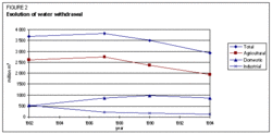
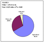
In 1994, the total water withdrawal for agricultural, domestic and industrial purposes was 2,925 million m3, of which 66% was used for irrigation purposes (Figure 1). Since the mid-1980s, there has been a decrease in the total water withdrawal, mainly due to a decrease in agricultural and industrial water withdrawal (Figure 2). Around 200 million m3 of water was estimated to be necessary for fisheries, recreation and power generation.
The total quantity of produced wastewater in 1994 amounted to 817 million m3, of which 415 million m3 was treated and only 0.1 million m3 re-used.
Irrigation and drainage development
Irrigation development
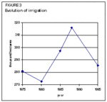
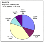
Irrigation in Armenia started about 3,000 years ago. Clay pipes were used to transport water to orchards and fields, and some of these water transportation systems are still intact. In the fourth century A.D. the total irrigated area was estimated at about 100,000 hectares (ha), in 1920 it had dropped to 61,000 ha, and in 1988 the area equipped was almost 316,000 ha. At present, the area equipped for full or partial control irrigation is estimated at almost 286,000 ha (Figure 3). The reason for the decrease in recent years has been, on the one hand, the earthquake of 1988 that destroyed part of the area, and on the other, the economic situation due to the transition period, that has made it difficult to keep or maintain the irrigation infrastructure. The major irrigation schemes are located on the left bank of the Araks River.
On over 90% of the area equipped for irrigation, surface irrigation is practiced. This surface irrigation can be divided into four categories: furrow irrigation; borderstrip irrigation; flooding; and irrigation using hydrants and flexible hose systems (Figure 4). Flooding is used where soil depth does not permit grading of either furrows or borderstrips. The water is let out over the land by cutting an irrigation head canal at intervals. In the case of irrigation using hydrants, the hydrants are generally spaced in a 50 x 50 m grid and discharge water onto the ground, from where it is distributed by any of the surface irrigation methods. Conveyance of water to the hydrant is by buried steel pipes, but may be by open canals further upstream. Sprinkler irrigation and micro-irrigation are practiced on the remaining 10% of the area equipped for full or partial control irrigation.
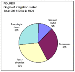
On 12% of the equipped area, groundwater is used for irrigation. The remaining part is irrigated from surface water through reservoirs, river diversion or pumping in rivers (Figure 5).
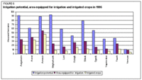
The irrigation potential has been estimated at 653,651 ha. Figure 6 shows the irrigation potential by province, the area equipped for irrigation, and the irrigated cropped area. In 1995, 44% of the irrigation potential had already been equipped for irrigation in the country, while a little over 60% of the area equipped for irrigation was actually cropped. In 1994, the area salinized by irrigation was estimated at 33,700 ha.
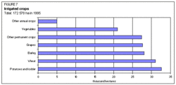
In 1995, almost one-third of the irrigated area was occupied by permanent crops, mainly grapes. Cereals, mainly wheat and barley, covered a little over one-third of the irrigated area (Figure 7).
Drainage development
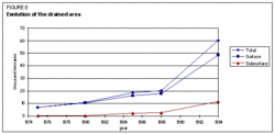
The total drained area increased from 6,900 hectares (ha) in 1975 to 60,400 ha in 1994, with a major increase from 1989 onwards (Figure 8). Most of the drainage is surface drainage.
Institutional environment
The most important institutions involved in water resources development and management are:
- The Ministry of Food and Agriculture with:
- The Department of Water Economy and Improvement, including the `Hayjirtntes' State Enterprise, which is in charge of the maintenance of irrigation schemes;
- The Central Water Board, which is in charge of all matters relating to the utilization of the water resources, including water quality;
- The Research Centre of Water Problems and Hydrology, which is involved in the complex utilization of water resources, their allocation, as well as in studies concerning hydro-engineering;
- The `Jrambar' State Enterprise, which is in charge of the maintenance of irrigation dams;
- The `Hayjirnackhagits' Institute, which is in charge of designing irrigation schemes and of studying the future prospects for water utilization;
- The Ministry of Environment and Groundwater:
- The Department of Geology and Geological Engineering, which is in charge of exploring the groundwater resources;
- The Department of Water Resources Utilization, which is in charge of the effective utilization of water resources and their conservation;
- The Ministry of Urban Development:
- The `Hayjirmughkojughi' State Enterprise, which is responsible for the maintenance of the domestic water supply network in the country, except in Yerevan city, where it is the responsibility of Yerevan's `Hayjirmughkojughi' Department;
- The Administration of Hydrometeorology is involved in the study of the water bodies (rivers, lakes, ponds, etc.).
Trends in water resources management
Much of Armenia's agriculture is based on irrigation. At present, 70% of the cultivated area is equipped for irrigation. However, the irrigation systems are in a deteriorating condition, which may lead to extreme environmental damage. Almost 70% of the equipped area needs rehabilitation. In addition, the management of irrigation systems requires adjustments to meet the needs of the recently privatized farms. According to a World Bank country study, the rehabilitation of critical water infrastructure facilities and the adjustment of irrigation management practices should receive very high priority.
The overall water use efficiency, from water source to crop, is estimated to be less than 35% for gravity systems. Potentially, with large savings along the existing irrigation systems and the development of new, non-utilized water resources, much more land could be irrigated. The World Bank has proposed several measures to increase the efficiency of the irrigation system: the setting up of pilot projects to test alternative delivery unit sizes; water meters and field distribution systems; and the organization of Water User Associations (WUAs) to be responsible for operating and maintaining facilities associated with their members' farms. All institutions related to irrigation use should then be directed to improving their services to the water users.
From an environmental perspective, the restoration of Lake Sevan's ecosystem is very important and should take priority.
Further Reading
- Water profile of Armenia, Food and Agriculture Orgnization.
- The World Factbook: Armenia, Central Intelligence Agency.
- The World's Water: Information on the World's Freshwater, the Pacific Institute for Studies in Development, Environment, and Security.
- Armenia Water Management Program, USAID.
- Department of Statistics of the Republic of Armenia. 1995. Summarized data.
- FAO. 1993. Irrigation subsector review and project identification report. FAO Investment Centre/ World Bank cooperative programme. Report No 79/93 CP - ARM 2. 66p. + 3 annexes.
- Hayjirnackhagits Institute. 1993. The program of utilization of water resources within the Republic of Armenia. Ministry of Food and Agriculture.
- Ministry of Food and Agriculture of the Republic of Armenia. The annual reports of `Hayjirthyt' 1975, 1980, 1985, 1988, 1994, 1995.
- World Bank. 1995. Armenia: the challenge of reform in the agricultural sector. A World Bank country study. Washington, D.C. 198 p.
| Disclaimer: This article is taken wholly from, or contains information that was originally published by, the Food and Agriculture Organization. Topic editors and authors for the Encyclopedia of Earth may have edited its content or added new information. The use of information from the Food and Agriculture Organization should not be construed as support for or endorsement by that organization for any new information added by EoE personnel, or for any editing of the original content. |