Guayanan Highlands moist forests
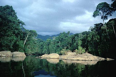
Nichare, Caura River, Venezuela. (Photograph by David Olson)
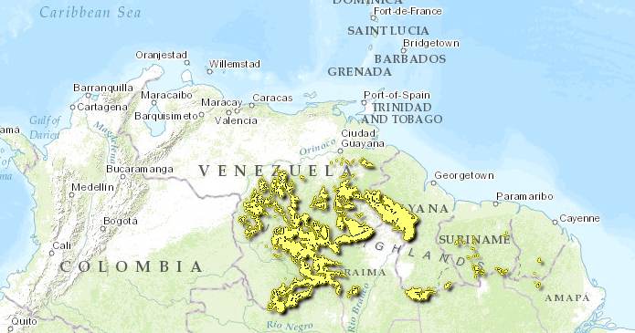
Introduction This ecoregion (Guayanan Highlands moist forests) is located in the highlands of southern Venezuela and northern Brazil, and extends into western Guyana and eastern Colombia. The region sits on the Guayanan Shield which underlies the northern region of South America. It hosts vast expanses of tall primary rainforest and open, treeless or nearly treeless savannas, and rich gallery forests. Elevations range from 500-1500 meters above sea level, and the climate is seasonal and humid, with 2,000-2,400 millimeters (mm) rainfall annually. Here, rugged terrain and unique creatures abound, as this region is an elevational "island" surrounded by llanos and lowland forest.
Location and General Description
 WWF
WWF
Situated in southeastern Venezuela in northern South America, the Guayanan Highlands ecoregion is distinct from other ecoregions in Amazonia due to its montane physiography. It hosts vast expanses of tall primary rainforest and open, treeless or nearly treeless savannas interrupted by gallery forests. The region is perforated by a series of ancient uplands and highlands between 500 and 3,000 m in elevation, the tallest ones are comprised in the Tepui ecoregion (described separately). Portions of the Guayanan Highlands ecoregion lie in the northernmost tip of Brazil, with small slivers in western Guayana and eastern Colombia. Most of this ecoregion lies within the eastern portion of the Orinoco Basin which drains into the Caribbean Sea from Venezuela. Another portion drains into the Amazon Basin. The major rivers entering the Orinoco Basin from this ecoregion are the Orinoco headwaters, the Ventuari, Caroní, Paragua, and Caura in Venezuela. In the southern potions, the Rio Uraricuera and Rio Branco (in Brazil) drain into the Amazon.
The ecoregion sits upon the Guayana Shield which underlies the northern region of South America. It consists of a rock basement with a variety of igneous and metamorphic rocks formed during different geological events. The upland terraces and mountains of the Guayana Shield are remnants of highly weathered and ancient parent material consisting mostly of quartzitic or sandstone rocks, although granitic rock types persist in some areas. The lowland plains emerged only recently from lacustrine and marine environments. The soils are generally sandy and poor in nutrients. The seasonal climate is humid to subhumid with 2,000 to 2,400 mm of rainfall distributed evenly though the year. The average annual temperature is approximately 24° C.
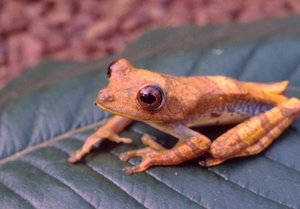 Tree frog. (Photograph by James L. Patton and CalPhotos)
 The landscape is a mixture of mostly forested lowlands of undulating peneplains and floodplains with a patchwork of upland elements. The topographic features of the uplands include rounded hills and low mountaintops from 500 to 1,500 m elevation, undulating high plains, lower slopes of the Tepuis, and summit areas of the lower Tepuis. The southeastern uplands of Venezuela are mostly unexplored botanically, but the ecoregion is characterized by high floristic and ecological diversity.
The peneplains lie between the Caura and Paragua Rivers that bisect the ecoregion and comprise gently undulating lowlands interspersed with low hills to 500 m elevation. These rolling lowlands host tall evergreen forests (30-40 m) with dense crowns and some emergent trees in the genera Calophyllum, Anacardium, Manilkara, Protium, Inga, Parkia, Copaifera, Erythrina, and Dipteryx. On the plains, abundant trees include Micropholis melinoniana, Dacroydes sp., Euterpe precatoria, and Quassia cedron. In the hilly habitat, fewer emergents are represented in forests of Newtonia suaveolens, Couratari guanensis, Alexa sp., Euterpe precatoria, and Micrandra minor.
The annually flooded riverine forests in the ecoregion are similar in both physiognomy and composition to the flooded forests of Amazonia. Some of the more important tree species on the upper Orinoco portion of the ecoregion include Combretum frangulifolium, Gustavia augusta, Pterocarpus sp., Etaballia dubia, Albizia corymbosa, Spondias mombin, Mabea nitida, Eschweilera tenuifolia, Astrocaryum aculeatum, and Inga spp. The tree species that occupy the floodplains have a broad distribution across Amazonia. They are exemplified by Caryocar microcarpum, Caraipa densifolia ssp. densifolia, Macrolobium acaciaefolium, Abuta grandfolia, and Panopsis rubescens.
Biodiversity Features
The region hosts 209 mammals. Many are widespread Amazonian species, including jaguars (Panthera onca), pumas (Puma concolor), tapirs (Tapirus terrestris), two peccaries (Tayassu pecari and T. tajacu), and deer (Mazama spp.). Other mammals that have a restricted distribution include several opossums (Didelphis albiventris, Lutreolina crassicaudata, and Marmosa robinsoni), bats (Pteronotus davyi, Lonchorhina fernandezi, and Sturnira ludovici), an endemic olingo (Bassaricyon beddardi), and endemic rodents (Sciurus flammifer, Proechimys hoplomyoides, and Dasyprocta guamara).
The avifauna is comprised of about 631 species, few of which are endemics. A number of species have a restricted distribution; however, including white-cheeked pintails (Anas bahamensis), aplomado falcons (Falco femoralis), brown-throated parakeets (Aratinga pertinax), pavonine cookoos (Dromococcyx pavoninus), vermiculated screech owls (Otus guatemalae), burrowing owls (Athene cunicularia), five species of emeralds and hummingbirds in the Amazilia genera, chestnut-tipped toucans (Aulacorhynchus derbianus), smoke-colored peewees (Contopus fumigatus), orange-crowned orioles (Icterus auricapillus), gray seedeaters (Sporophila intermedia), two-banded warblers (Basileuterus bivittatus), and black-backed water-tyrants (Fluvicola albiventer).
Reptiles and amphibians are abundant. The more famous snakes that occur here including the fer-de-lance (Bothrops asper), palm pit-vipers (Bothriechis spp.), coral snakes (Micrurus spp.), boa constrictors (Boa constrictor), and bushmasters (Lachesis muta). Iguanas (Iguana iguana) are ubiquitous and tegus lizards (Tupinambis) common.
Current Status
Many of the interior forests of the Guayana highlands ecoregion are intact. Habitat destruction from large-scale agriculture, mining, and cattle raising occurs mostly along the northern and northeastern periphery of the ecoregion, nearest urban centers. Prohibition of commercial logging in the Venezuelan state of Amazonas curtails activities, but other areas are subjected to logging activities. The largest UNESCO biosphere reserve in the tropics, the Alto Orinoco-Casiquiare Biosphere Reserve, lies partly in this ecoregion. The Canaima National Park protects 30,000 square kilometers (km2) of dense evergreen submontane and montane forests, shrublands, savannas, and broad-leaved meadows, and some high tepui vegetation. A number of other national parks have been established, but most are insufficiently staffed and with few or weak management plans. The national parks Parima-Tapirapecó in the southernmost tip of Venezuela, Serranía La Neblina in Venezuela, and Pico da Neblina in Brazil together cover about 40,000 km2 of evergreen lowland, submontane, and montane forests and a number of tepui peaks. Many small national monuments and forest reserves exist in this ecoregion, but mostly protect the highest zones of the tepuis.
Types and Severity of Threats
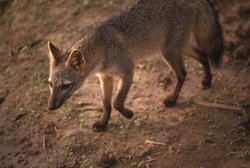 Crab-eating fox. (Photograph by Steve Cornelius/WWF)
 Until recently, the habitat of the Guayana Highlands ecoregion has been protected from encroaching commercial exploitation by inaccessibility. Most development and colonization is occurring in the north of the ecoregion, but timber activities are penetrating the remote interior following road-building activities. The spread of mining and large-scale agricultural developments in the interior of the ecoregion is also steady. Both legal and illegal mining for gold, diamonds, bauxite, and iron ore pose a serious threat to aquatic and terrestrial habitats in some areas of this ecoregion. Fires set by miners and agriculturalists can pose a threat to habitat if they are uncontrolled. Unregulated tourism in Amerindian villages also adversely impacts both the cultural and ecological richness of the area. Several hydroelectric dams are currently being constructed, which threaten vast areas of savanna and riparian habitat along the Caroni River. This series of 5 dams being constructed on the Caroni River, and several others being planned on the Paragua River could be devastating to riparian ecosystems and will flood several thousand square kilometers of river basin.
Justification of Ecoregion Delineation
Delineation’s for this ecoregion were derived from several country specific vegetation coverage maps, and blending was done along the borders according to expert opinion. In Brazil, delineations are according to the IBGE map, and the linework follows the following vegetational coverages for the Amazon floristic province: dense submontane ombrophilous forests and dense montane ombrophilous forests. The small portion which extends into Guyana was derived by tracing the logical continuation of the portion from Venezuela, and referenced with Huber et al. Within Venezuela we used Huber’s map, and lumped the following "evergreen forests" subregions: Tupuyes Meridionales, Sierra Parima, Tepuyes Centro-Meridionales, Tepuyes Noroccidentales, Jaua-Maigualida, Caroní Medio, Penillanura del Alto Paragua, and Piedemonte Noroccidental. In Brazil, we used the IBGE vegetation map, and followed the delineations of "dense montane ombrophilous forests" and "dense submontane ombrophilous forests" of the border region with Venezuela.
Additional information on this ecoregion
- For a shorter summary of this entry, see the WWF WildWorld profile of this ecoregion.
- To see the species that live in this ecoregion, including images and threat levels, see the WWF Wildfinder description of this ecoregion.
- World Wildlife Fund Homepage
Further Reading
- Daly, D. C., and J. D. Mitchell. 2000. Lowland vegetation of tropical South America. Pages 391-453 in D. L. Lentz, editor, Imperfect Balance: Landscape transformations in the Precolumbian Americas. New York: Columbia University Press.
- Fundação Instituto Brasilero de Geografia Estatástica-IBGE. 1993. Mapa de vegetação do Brasil. Map 1:5,000,000. Rio de Janeiro, Brazil.
- Huber, O., and C. Alarcon. 1988. Mapa de vegetación de Venezuela. 1:2,000,000. Ministerio del Ambiente y de los Recursos Naturales Renovables, Caracas, Venezuela.
- Huber, O., G. Gharbarran, and V. Funk. 1995. Vegetation map of Guyana (preliminary version). 1:1,000,000. Centre for the Study of Biological Diversity, University of Guyana, Georgetown, Guyana.
- Huber, O. 1995a. Conservation of the Venezuelan Guayana. Pages 193-218 in P. E. Berry, B. K. Holst, and K. Yatskievych, editors, Flora of the Venezuelan Guayana. St. Louis: Missouri Botanical Garden and Timber Press. ISBN: 0881923133
- Huber, O. 1995b. Vegetation. Pages 97-160 in P. E. Berry, B. K. Holst, and K. Yatskievych, editors, St. Louis: Flora of the Venezuelan Guayana. Missouri Botanical Garden and Timber Press.
| Disclaimer: This article is taken wholly from, or contains information that was originally published by, the World Wildlife Fund. Topic editors and authors for the Encyclopedia of Earth may have edited its content or added new information. The use of information from the World Wildlife Fund should not be construed as support for or endorsement by that organization for any new information added by EoE personnel, or for any editing of the original content. |