Ecoregions of Côte d'Ivoire

Source: The Map Library
Ecoregions of Countries Collection ![]()
Côte d'Ivoire has six ecoregions that occur partly within its borders:
- Guinean mangroves
- Eastern Guinean forests
- Western Guinean lowland forests
- Guinean montane forests
- Guinean forest-savanna mosaic
- West Sudanian savanna

Contents
Guinean mangroves
The Guinean Mangroves, influenced by a large tidal range and high inputs of freshwater, contain stands that are more than 25 m in height. As the best developed mangroves in western Africa, this ecoregion provides important habitat for migratory birds and endangered species such as the West African manatee and the pygmy hippopotamus. However, the mangrove habitat is threatened by agriculture and urban development and has been affected by poor rainfall over the entire region during the past three decades.
Eastern Guinean forests
The Eastern Guinean Lowland Forest extends from the east banks of the Sassandra River in western Côte d’Ivoire (06° 05’ W) to the edge of Lake Volta (01° 50’ W) in Ghana. There is a small extension of this ecoregion east of Lake Volta into the Togo Hills, which lie mostly in Togo but extend across the border to easternmost Ghana, with one outlier in Benin. The dry lowland area on the eastern edge of the ecoregion is termed the Dahomey Gap and is a major biogeographical barrier. In the border areas between Ghana and Côte d’Ivoire, the ecoregion extends to 8° N and gradually fades into a mosaic of forest patches and tall grasslands of the Guinea Forest-Savanna Mosaic.
There is a high diversity of non-human primates here, including western chimpanzee (Pan troglodytes verus). Thirteen amphibians are strictly endemic to the ecoregion and, together with plants and butterflies, these groups illustrate the clearest difference from the contiguous lowland forests further west.
The threats facing this ecoregion are numerous and diverse. Considerable areas of forestland have been converted to farmlands, often using a rotation ‘farmbush’ farming system. The total area under protection is relatively small, and pressure to extract forest resources, especially timber, fuel wood, and charcoal remains high due to a ready timber export market and increasing urban population centers such as Abidjan and Accra. Habitat loss and hunting for bushmeat has recently caused the extinction of one non-human primate subspecies, Miss Waldron’s colobus (Piliocolobus badius waldroni), and the endemic Togo mouse (Leimacomys buettneri) may also be extinct.
Western Guinean lowland forests
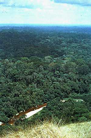 Tai National Park, Ivory Coast Photograph by WWF/Francis Lauginie The Western Guinean Lowland forest stretches from eastern Guinea, across Sierra Leone and Liberia, to the Sassandra River in southwestern Côte d’Ivoire. It is the most westerly tropical rainforest block on the African continent.
The flora and fauna is distinctive, with larger numbers of narrowly endemic species than in the contiguous Eastern Guinean lowland forests ecoregion to the east. The two endemic duikers, Jentink’s duiker (Cephalophus jentinki) and zebra duiker (Cephalophus zebra), 13 strictly endemic amphibians, and three strictly endemic birds illustrate the distinctive species-composition of the ecoregion. Non-human primates are also diverse and include the Diana monkey (Cercopithecus diana diana), Campbell’s monkey (Cercopithecus mona campbelli) and western red colobus (Piliocolobus badius badius.
Much of the natural forest in this ecoregion has been lost to human activities, with almost all remaining forest modified by past human disturbance. The loss has been severe in Côte d’Ivoire, where the national priorities favored export crops, which led to vast forests being cleared. Sierra Leone has also experienced severe loss of its natural forest, dating back to the 19th century when timber was exported during British colonial administration. Subsistence agriculture in the wake of commercial logging has reduced the area of primary forest in Sierra Leone from more than 70 percent to just under 6 percent. Further losses in forest coverage are projected at five percent should the trend in deforestation continue. Both Côte d’Ivoire and Sierra Leone show the greatest level of fragmentation of natural forests, while Liberia still retains large forest blocks. The largest stands of high forest in all of these countries are found within so-called ‘protected areas’ and ‘forest reserves’. Despite these titles, the management of protected areas and reserves is currently poor or non-existent, especially in Guinea, Sierra Leone and Liberia where civil conflicts drain resources to other areas. The total area of protected forest in this ecoregion is just under 3 percent for all National Parks and other reserves (IUCN levels II-IV) with international designations.
Guinean montane forests
The Guinean Montane Forest ecoregion consists of scattered mountains and high plateau areas that rise out of a gently undulating landscape. Parts of the ecoregion are found in four West African countries, from Guinea in the west to Côte d’Ivoire in the east. Some landscapes rise precipitously (e.g., Loma Mountains and Tingi Hills in Sierra Leone, and Mount Nimba on the border between Liberia, Guinea, and Côte d’Ivoire) while others are more gentle such as the Fouta Djallon in Guinea, a heavily eroded plateau with an elevation of 1,100 meters (m).
One of the peaks, Bintumani (on the Loma Mountains of Sierra Leone), is the highest peak west of Mount Cameroon. The broad range of elevation, coupled with the underlying geology and anthropogenic activities, have given rise to different plant associations on several of the mountains. Although details of the number of endemic plants are not fully compiled, 35 plant species are known to be strictly endemic, with several mountains containing their own unique plant species, such as the orchid Rhipidoglossum paucifolium, known only from Mount Nimba. The fauna is also diverse with close to 15 strictly endemic vertebrate species, including species found on single mountains, such as the Mount Nimba endemic toad, Nimbaphrynoides occidentalis.
Mining on Mount Nimba, slash and burn farming, and human-made fires were the major threats prior to a decade of civil conflicts in Sierra Leone and Liberia.
In general this ecoregion is not well protected in formal conservation areas. In total, there are two Biosphere Reserves (Monts Nimba in Liberia, Guinea, and Côte d’Ivoire and Massif du Ziama in Guinea) and two World Heritage Reserves (Mount Nimba in Côte d’Ivoire and Mount Nimba in Guinea). The current status of this ecoregion is poorly known because of continuing civil war in the region. A conservation assessment should be done immediately following cessation of fighting, and efforts made to declare the Loma Mountains and Tingi Hills as national parks.
Guinean forest-savanna mosaic
The Guinean Forest-Savanna Mosaic runs through West Africa, dividing the Guinean rain forest from the Sudanian savanna. The interlacing forest, savanna, and grassland habitats are highly dynamic, and the proportion of forest versus other habitat components has varied greatly over time.
These forest-savanna ecotones may offer critical habitat for differentiation and speciation. A number of large charismatic mammal species are found here, but national parks attract few visitors.
The protected areas system is under funded and only covers two percent of the area of this ecoregion.
West Sudanian savanna
The West Sudanian Savanna stretches in a band across West Africa south of the Sahel, from Senegal and Gambia to the eastern border of Nigeria. It lies between the Guinean Forest-Savanna Mosaic to the south, and the Sahelian Acacia Savanna to the north.
The West Sudanian Savanna is a hot, dry, wooded savanna composed mainly of large tree species and long "elephant" grass.
The habitat has been greatly reduced, degraded, and fragmented by agricultural activities, fire, and clearance for wood and charcoal, while populations of most of the larger mammal species have been decimated by over-hunting. Although many protected areas exist, most are under-resourced "paper parks" with little active enforcement on the ground.
The hot climate and poor infrastructure have resulted in little development of tourism in the region.
The habitats of the ecoregion are principally threatened by the agricultural and herding activities of the local populations. There are considerable pressures on the land from seasonal farming, grazing animals, cutting trees and bushes for wood, burning woody material for charcoal, and from wild fires. All of these pressures have reduced and degraded natural habitats. Climatic desiccation is a further threat, exacerbating human pressures, as the ability of the ecosystem to recover from overuse is reduced when there is little rainfall.
The main threats to the animal species of the ecoregion come from human use of the habitat and especially from hunting. For the larger mammals, hunting for food and for sport has removed many species over wide areas; species such as giraffe, wild dog, lion, and elephant are now much reduced (some to single viable populations). The black rhinoceros (Diceros bicornis) was extirpated decades ago. Even within protected areas, commercial and subsistence poaching is rife, and illegal grazing of livestock occurs extensively.
A particular threat to the migratory wildlife (especially birds) is the drainage and pollution of wetlands. Large-scale agricultural initiatives, dams, and river diversion schemes are proposed, and in some cases have been completed. These can change or reduce flood regimes of inland wetlands, which are generally seasonal and dependent on rainfall. In Nigeria, in particular, some of the agricultural schemes have damaged these wetlands, with potential negative consequences for the wildlife and the people's whose livelihoods depend on fishing or seasonal farming related to the floods.
Context
Ecoregions are areas that:
[1] share a large majority of their species and ecological dynamics;
[2] share similar environmental conditions; and,
[3] interact ecologically in ways that are critical for their long-term persistence.
Scientists at the World Wildlife Fund (WWF), have established a classification system that divides the world in 867 terrestrial ecoregions, 426 freshwater ecoregions and 229 marine ecoregions that reflect the distribution of a broad range of fauna and flora across the entire planet.
National Parks:
- Assagny National Park
- Banco National Park
- Comoé National Park
- Îles Ehotilés National Park
- Marahoué National Park
- Mont Nimba National Park
- Mont Péko National Park
- Mont Sângbé National Park
- Taï National Park
See also: