Ecoregions of Burundi
| Topics: |
This content is not assigned to a topic
|
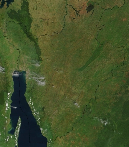
Satellite image of Burundi in February 2003. Source: NASA
Ecoregions of Countries Collection ![]() Burundi has three ecoregions that occur in part within its borders:
Burundi has three ecoregions that occur in part within its borders:
- Albertine Rift montane forests (green)
- Victoria Basin forest-savanna mosaic (yellow)
- Central Zambezian Miombo woodlands (orange)

Contents
Albertine Rift montane forests
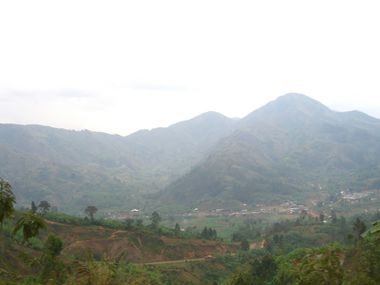 Cibitoke hills. Source: New York University Cibitoke hills. Source: New York University
|
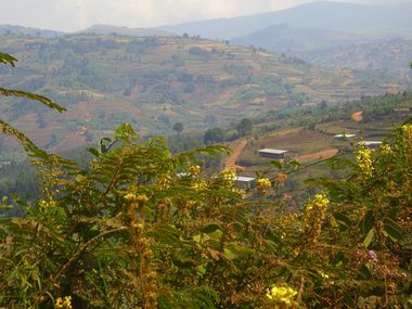 Muramvya hills. Soource: New York University Muramvya hills. Soource: New York University
|
The Albertine Rift Mountains ecoregion is an area of exceptional faunal and moderate floral endemism. These mountains also support the Mountain gorilla (Gorilla gorilla beringei), which is one of the most charismatic flagship species in Africa, and an effective target for much of the current conservation investment in the area. The mountain chain comprising the Albertine rift straddles the borders of five different nations, and this makes effective ecoregional conservation a challenge in the area. Although there are a number of National Parks and Forest Reserves in the area, the recent wars have made their management difficult over much of the ecoregion. Additional threats include conversion of most forest areas outside reserves into farmland, together with logging, firewood collection, and bushmeat hunting within the remaining forest areas.
The ecoregion covers a large part of western Burundi represents the largest ecoregion in the Albertine rift. The ecoregion is dominated by montane rainforest, but in the west, marginal fringes of the Guineo-Congolian rainforest impinge on the lower slopes (down from 500-800 m), and forest/savanna mosaic habitats border it to the east in Uganda, Rwanda, and Burundi.
Throughout much of the ecoregion, especially in Burundi and Rwanda, the rural human population density is amongst the highest in Africa. This places considerable pressure on the remaining forest resources as most families live on shambas undertaking subsistence farming. In many areas the only stands of forest remaining are within Forest Reserves or National Parks, or those stands found in the most mountainous and therefore inaccessible areas
Victoria Basin forest-savanna mosaic
which covers much of Uganda and Rwanda reaches into Burundi from the north. The ecoregion is most noted for its high species diversity and endemism resulting from the mixture of habitat types and species from both western and eastern Africa. Add the scattered wetland habitat, and you get an abundance of animals representing different habitat types. These include more than 310 species of trees and shrubs, 280 species of birds, 220 species of butterflies, and 100 species of moths. The tropical moist climate here has two rainy seasons--one in April and May and another in October and November. These help replenish the waters for the many wetland areas of the ecoregion.
Central Zambezian Miombo woodlands
The Central Zambezian Miombo Woodland is one of the largest ecoregions in Africa, ranging from Angola up to the shores of Lake Victoria in Tanzania and is the largest ecoregion in Burundi. All the typical miombo flora are represented here, but this region has a higher degree of floral richness, with far more evergreen trees than elsewhere in the miombo biome. The harsh dry season, long droughts, and poor soils are ameliorated by the numerous wetlands spread throughout the ecoregion, covering up to 30 percent of the region’s total area. As a result, a diverse mix of animals is found here, from sitatunga (swamp-dwelling antelopes), to chimpanzees, in the world-famous Gombe Stream Reserve. The bird life is also exceptionally rich, as is the fauna of some amphibian groups. The ecoregion contains areas of near-wilderness with exceptionally low human populations and extensive protected areas. Other parts of the ecoregion, typically close to lakes and mountains, have higher population densities and the miombo is much more degraded. Bushmeat hunting, dryland agriculture, deforestation especially for charcoal production near larger towns, and mining are increasing threat in this ecoregion.
Context
Ecoregions are areas that:
[1] share a large majority of their species and ecological dynamics;
[2] share similar environmental conditions; and,
[3] interact ecologically in ways that are critical for their long-term persistence.
Scientists at the World Wildlife Fund (WWF), have established a classification system that divides the world in 867 terrestrial ecoregions, 426 freshwater ecoregions and 229 marine ecoregions that reflect the distribution of a broad range of fauna and flora across the entire planet.
Further Reading
- Bailey, Robert G. 2002. Ecoregion-Based Design for Sustainability. Springer-Verlag. New York, New York. 240pp., 100 illus. ISBN 0-387-95430-9
- Bailey, Robert G. 1998. Ecoregions: The Ecosystem Geography of the Oceans and the Continents. Springer-Verlag. New York, New York. 192pp., 107 illus., 10 tables. ISBN 0-387-98305-8
- Bailey, Robert G. 1996. Ecosystem Geography. Springer-Verlag. New York, New York. 216pp., 122 illus., 14 tables. ISBN 0-387-94586-5
- Omernik, James M., 1995. Ecoregions: A spatial framework for environmental management. In: Biological Assessment and Criteria: Tools for Water Resource Planning and Decision Making. Davis, W.S. and T.P. Simon (eds.) Lewis Publishers, Boca Raton, FL. Pp. 49-62. ISBN: 0873718941.
- World Wildlife Fund, Ecoregions homepage, Accessed 1 May 2009.