Volcanoes/Volcanology
< Volcanoes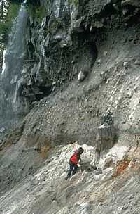
Volcanology is the scientific study of volcanoes.
Volcanic minerals
Volcanic minerals are the ones expected to be found in volcanic rocks.
Theoretical volcanology
Def. the scientific study of volcanoes is called volcanology.
Vulcanology is a variant spelling of volcanology.
"The word "volcano" is used to refer to the opening from which molten rock and gas issue from Earth's interior onto the surface, and also to the cone, hill, or mountain built up around the opening by the eruptive products. [These products include] ash clouds, fire fountains, lava flows, spatter cones, glowing avalanches, and steam eruptions [...]. Volcano types include strato, cinder cone, basaltic shield, complex, and island-forming."[1]
Theoretical volcanoes
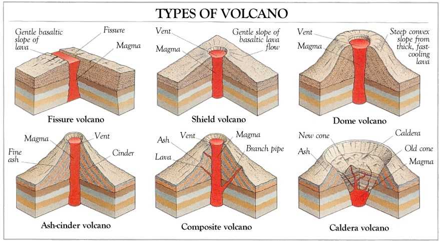

The diagram at top shows six theoretical types of volcanoes:
- fissure,
- shield,
- dome,
- ash-cinder,
- composite, and
- caldera.
The second diagram shows
- a compound and complex volcano,
- a composite volcano,
- a somma volcano with cone inside earlier cone,
- a caldera,
- a shield volcano, and remnants
- lava dome,
- fissure vent row of craters,
- a cinder cone profile,
- a tuff cone,
- a tuff ring, and
- a maar.
Def. a mountain or hill, typically conical, having a crater or vent through which lava, rock fragments, hot vapor, and gas are or have been erupted from the Earth's, or another astronomical object's crust is called a volcano.
Def. a "vent or fissure on the surface of a planet (usually in a mountainous form) with a magma chamber attached to the mantle of a planet or moon, periodically erupting forth lava and volcanic gases onto the surface"[2] is called a volcano.
"A volcano is a rupture on the crust of a planetary-mass object, such as Earth, that allows hot lava, volcanic ash, and gases to escape from a magma chamber below the surface."[3]
Def. a "powerful volcano, often having an explosive or cataclysmic eruption"[4] is called a supervolcano.
Geology
With respect to volcanoes, the geology consists of the study of the materials they are made of, the processes that act on these materials, the products formed, and the history of these volcanoes and effects on life forms since each volcano's origin.
Electromagnetics
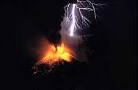
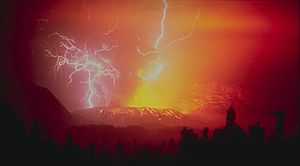
Many volcanic eruptions put on impressive lightning displays such as during the 1995 eruption of Mount Rinjani in Indonesia shown in the image on the right.
The image on the left shows spectacular lightning strikes around Galunggung.
"This stratovolcano with a lava dome is located in western Java. Its first eruption in 1822 produced a 22-km-long mudflow that killed 4,000 people. The second eruption in 1894 caused extensive property loss. The photo depicts a spectacular view of lightning strikes during a third eruption on December 3, 1982, which resulted in 68 deaths. A fourth eruption occurred in 1984."[1]
Volcanic rocks
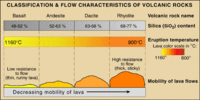
"The behavior of a lava flow depends primarily on its viscosity (resistance to flow), slope of the ground over which it travels, and the rate of lava eruption. Because basalt contains the least amount of silica and erupts at the highest temperature compared to the other types of lava, it has the lowest viscosity (the least resistance to flow). Thus, basalt lava moves over the ground easily, even down gentle slopes. Dacite and rhyolite lava, however, tend to pile up around a vent to form short, stubby flows or mound-shaped domes."[5]
Geoseismology
Sound "propagating through the [Sound Fixing and Ranging] SOFAR channel [may be used] to study underwater earthquakes, volcanoes and whales."[6]
"Between 100 and 200 kilometers below the Earth's surface, the temperature of the rock is near the melting point; molten rock erupted by some volcanoes originates in this region of the mantle."[7]
Monochromatic "seismic signals, typically between 3 and 12 Hz, with a lack of overtones [occurred on some seismic recordings from French Polynesia]. The signals were due to oceangoing T- waves, which were particularly active in 1991 and in the early months of 1992. The duration of individual blasts lasted from a few seconds to several minutes. [...] earthquakes and whales [were ruled out] as the source of the T-waves."[8]
The "waves originated at an underwater volcanic ridge in a poorly surveyed region of the South Pacific. New probing showed a flat-topped undersea volcano that rose to within 130 meters of the surface. [...] undersea volcanoes at shallow depths [are] capable of producing T-waves, where the pressure is low enough that bubbles can form in the hot lava."[8]
"Sound waves normally travel at about 1500 meters per second in seawater, but they can slow to one meter per second in a cloud of bubbles generated by the steam from a volcano."[8]
Volcanic activity
Volcanic activity may be activity from or by a volcano or activity from the sources of volcanoes.
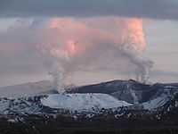
On Iceland this year there is an increase in volcanic activity as shown in the photo on the right.
"Our research makes the connection between recent accelerated uplift and the accelerated melting of the Icelandic ice caps."[9]
"There is actually geological evidence that during the past deglaciation about 12,000 years ago, volcanic activity in some regions of Iceland increased thirtyfold. In fact, some estimate that this uplift could increase the frequency of volcanic eruptions such as the 2010 eruption of Eyjafjallajokull, which had negative consequences worldwide."[10]
Volcanicity
Def. the "level of power of a volcano"[11] is called its volcanicity.
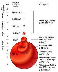
"The Volcanic Explosivity Index, or VEI, was proposed in 1982 [shown on the right] as a way to describe the relative size or magnitude of explosive volcanic eruptions. It is a 0-to-8 index of increasing explosivity. Each increase in number represents an increase around a factor of ten. The VEI uses several factors to assign a number, including volume of erupted pyroclastic material (for example, ashfall, pyroclastic flows, and other ejecta), height of eruption column, duration in hours, and qualitative descriptive terms."[12]
"In the figure [on the right], the volumes of several past explosive eruptions and the corresponding VEI are shown. Numbers in parentheses represent total volume of erupted pyroclastic material (tephra, volcanic ash, and pyroclastic flows) for selected eruptions; the volumes are for uncompacted deposits. Each step increase represents a ten fold increase in the volume of erupted pyroclastic material."[12]
"A series of small to moderate explosive eruptions from Mono-Inyo Craters Volcanic Chain, California, during the past 5,000 years ranged from VEI of 1 to 3. The 18 May 1980 eruption of Mount St. Helens was a VEI 5 with an erupted volume of about 1 km3. The 1991 eruption of Mount Pinatubo had a volume of about 10 km3 and a VEI of 5 to 6. The 1815 eruption of Tambora, Indonesia, had a VEI of 7 and a volume in excess of 100 km3. The eruption of Long Valley Caldera about 760,000 years ago had a VEI of 7 and a volume of 600 km3 of material. The largest explosive eruption on the figure occurred at Yellowstone about 600,000 years ago with a VEI of 8 and a volume of about 1,000 km3 of material."[12]
"The VEI has some similarities to the Richter magnitude scale used to measure earthquakes. It has a simple numerical index of increasing magnitude of explosivity, with each interval representing an increase of about a factor of 10 in the volume of erupted tephra."[12]
"There are no known explosive events with a VEI larger than 8."[12]
The "amount of sulfur dioxide gas injected high into the atmosphere (which is not necessarily related to the size of an eruption) [is] a critical factor in determining the climatic impact of volcanic eruptions. [The] VEI is primarily used to estimate the relative size of an explosive eruption."[12]
"Large explosive eruptions occur much less frequently than small ones. Through 1994, the record of volcanic eruptions in the past 10,000 years maintained by the Global Volcanism Program of the Smithsonian Institution shows that there have been 4 eruptions with a VEI of 7, 39 of VEI 6, 84 of VEI 5, 278 of VEI 4, 868 of VEI 3, and 3,477 explosive eruptions of VEI 2."[12]
Volcanism
Def. any remnants "of the natural phenomena and processes associated with the action of volcanos, geysers and fumaroles"[13], especially any remnants of past volcanic activity, are called volcanism.
"In contrast to the Proterozoic, Archean rocks are often heavily metamorphized deep-water sediments, such as graywackes, mudstones, volcanic sediments and banded iron formations. Greenstone belts are typical Archean formations, consisting of alternating high- and low-grade metamorphic rocks. The high-grade rocks were derived from volcanic island arcs, while the low-grade metamorphic rocks represent deep-sea sediments eroded from the neighboring island arcs and deposited in a forearc basin. In short, greenstone belts represent sutured protocontinents.[14]"[15]
"Greenstone belts are zones of variably metamorphosed mafic to ultramafic volcanic sequences with associated sedimentary rocks that occur within Archaean and Proterozoic cratons between granite and gneiss bodies."[16]
"The name comes from the green hue imparted by the colour of the metamorphic minerals within the mafic rocks. Chlorite, actinolite and other green amphiboles are the typical green minerals."[16]
"A greenstone belt is typically several dozens to several thousand kilometres long and although composed of a great variety of individual rock units, is considered a 'stratigraphic grouping' in its own right, at least on continental scales."[16]
""Greenstone belts" are distributed throughout geological history from the Phanerozoic Franciscan belts of California where blueschist, whiteschist and greenschist facies are recognised, through to the Palaeozoic greenstone belts of the Lachlan Fold Belt, Eastern Australia, and a multitude of Proterozoic and Archaean examples."[16]
"Archaean greenstones are found in the Slave craton, northern Canada, Pilbara craton and Yilgarn Craton, Western Australia, Gawler Craton in South Australia, and in the Wyoming Craton in the US. Examples are found in South and Eastern Africa, namely the Kaapvaal craton and also in the cratonic core of Madagascar, as well as West Africa and Brazil, northern Scandinavia and the Kola Peninsula (see Baltic Shield)."[16]
"Phanerozoic ophiolite belts and greenstone belts occur in the Franciscan Complex of south-western North America, within the Lachlan Fold Belt, the Gympie Terrane of Eastern Australia, the ophiolite belts of Oman and around the Guiana Shield."[16]
Volcanic ashes
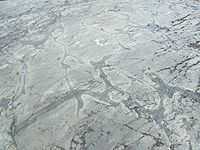
"Volcanic ash collected in Randle, Washington, [in the image on the right, is] located about 40 km NNE of Mount St. Helens."[17]
"The north edge of the eruption cloud of May 18, 1980, passed over Randle and deposited between 1 and 2 cm of ash on the community. At the same distance along the axis of the eruption cloud, however, about 7 cm of ash and larger-sized tepra fell to the ground."[17]
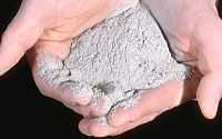
"Volcanic ash consists of rock, mineral, and volcanic glass fragments smaller than 2 mm (0.1 inch) in diameter, which is slightly larger than the size of a pinhead. Volcanic ash is not the same as the soft fluffy ash that results from burning wood, leaves, or paper. It is hard, does not dissolve in water, and can be extremely small--ash particles less than 0.025 mm (1/1,000th of an inch) in diameter are common."[17]
"Ash is extremely abrasive, similar to finely crushed window glass, mildly corrosive, and electrically conductive, especially when wet."[17]
"Volcanic ash is created during explosive eruptions by the shattering of solid rocks and violent separation of magma (molten rock) into tiny pieces. Explosive eruptions are generated when ground water is heated by magma and abruptly converted to steam and also when magma reaches the surface so that volcanic gases dissolved in the molten rock expand and escape (explode) into the air extremely rapidly. After being blasted into the air by expanding steam and other volcanic gases, the hot ash and gas rise quickly to form a towering eruption column directly above the volcano."[17]
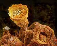
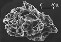
The second image down on the right is a close "view of a single ash particle from the eruption of Mount St. Helens; image is from a scanning electron microscope (SEM). The tiny voids or "holes" are called vesicles and were created by expanding gas bubbles during the eruption of magma."[17]
Research
Hypothesis:
- Volcanology may involve more electromagnetism than currently assumed.
Control groups

The findings demonstrate a statistically systematic change from the status quo or the control group.
“In the design of experiments, treatments [or special properties or characteristics] are applied to [or observed in] experimental units in the treatment group(s).[18] In comparative experiments, members of the complementary group, the control group, receive either no treatment or a standard treatment.[19]"[20]
Proof of concept
Def. a “short and/or incomplete realization of a certain method or idea to demonstrate its feasibility"[21] is called a proof of concept.
Def. evidence that demonstrates that a concept is possible is called proof of concept.
The proof-of-concept structure consists of
- background,
- procedures,
- findings, and
- interpretation.[22]
See also
References
- 1 2 R. Hadian (3 December 1982). "Galunggung, Indonesia". NOAA National Geophysical Data Center. Retrieved 2015-03-24.
- ↑ "volcano, In: Wiktionary". San Francisco, California: Wikimedia Foundation, Inc. 13 February 2015. Retrieved 2015-03-01.
- ↑ "Volcano, In: Wikipedia". San Francisco, California: Wikimedia Foundation, Inc. 20 February 2015. Retrieved 2015-03-01.
- ↑ "supervolcano, In: Wiktionary". San Francisco, California: Wikimedia Foundation, Inc. 19 September 2013. Retrieved 2015-03-02.
- ↑ J. Johnson (29 December 2009). "VHP Photo Glossary: Volcanic rocks". Menlo Park, California USA: USGS. Retrieved 2015-03-15.
- ↑ Tom Irvine (June 2006). "SOFAR Channel". VibrationData.com. Retrieved 2014-11-26.
- ↑ Eugene C. Robertson (14 January 2011). "The Interior of the Earth". Reston, Virginia USA: USGS. Retrieved 2014-12-01.
- 1 2 3 Tom Irvine (June 2006). "Seismo-acoustic T-waves". VibrationData.com. Retrieved 2014-11-26.
- ↑ Kathleen Compton (30 January 2015). "Melting Glaciers is Causing Iceland to Rise and May Increase Volcanic Activity". Iceland: Science World Report. Retrieved 2015-03-27.
- ↑ Catherine Griffin (30 January 2015). "Melting Glaciers is Causing Iceland to Rise and May Increase Volcanic Activity". Iceland: Science World Report. Retrieved 2015-03-27.
- ↑ Borganised (23 October 2008). "volcanicity, In: Wiktionary". San Francisco, California: Wikimedia Foundation, Inc. Retrieved 2015-03-21.
- 1 2 3 4 5 6 7 C. G. Newhall and S. Self (29 December 2009). "VHP Photo Glossary: VEI". Menlo Park, California USA: United States Geological Survey. Retrieved 2015-02-28.
- ↑ SemperBlotto (5 July 2007). "volcanism, In: Wiktionary". San Francisco, California: Wikimedia Foundation, Inc. Retrieved 2015-03-20.
- ↑ Stanley 1999, pp. 302–303
- ↑ "Geological history of Earth, In: Wikipedia". San Francisco, California: Wikimedia Foundation, Inc. December 21, 2012. Retrieved 2013-01-22.
- 1 2 3 4 5 6 "Greenstone belt, In: Wikipedia". San Francisco, California: Wikimedia Foundation, Inc. January 10, 2013. Retrieved 2013-01-22.
- 1 2 3 4 5 6 D.E. Wieprecht (18 May 1980). "VHP Photo Glossary: volcanic ash". Menlo Park, California USA: USGS. Retrieved 2015-03-09.
- ↑ Klaus Hinkelmann, Oscar Kempthorne (2008). Design and Analysis of Experiments, Volume I: Introduction to Experimental Design (2nd ed.). Wiley. ISBN 978-0-471-72756-9. http://books.google.com/?id=T3wWj2kVYZgC&printsec=frontcover.
- ↑ R. A. Bailey (2008). Design of comparative experiments. Cambridge University Press. ISBN 978-0-521-68357-9. http://www.cambridge.org/uk/catalogue/catalogue.asp?isbn=9780521683579.
- ↑ "Treatment and control groups, In: Wikipedia". San Francisco, California: Wikimedia Foundation, Inc. May 18, 2012. Retrieved 2012-05-31.
- ↑ "proof of concept, In: Wiktionary". San Francisco, California: Wikimedia Foundation, Inc. November 10, 2012. Retrieved 2013-01-13.
- ↑ Ginger Lehrman and Ian B Hogue, Sarah Palmer, Cheryl Jennings, Celsa A Spina, Ann Wiegand, Alan L Landay, Robert W Coombs, Douglas D Richman, John W Mellors, John M Coffin, Ronald J Bosch, David M Margolis (August 13, 2005). "Depletion of latent HIV-1 infection in vivo: a proof-of-concept study". Lancet 366 (9485): 549-55. doi:10.1016/S0140-6736(05)67098-5. http://www.ncbi.nlm.nih.gov/pmc/articles/PMC1894952/. Retrieved 2012-05-09.
External links
- World Organization of Volcano Observatories
- Global Volcanism Program, National Museum of Natural History (Smithsonian Institution)
- National Hazard Events Volcano Images
![]() This is a research project at http://en.wikiversity.org
This is a research project at http://en.wikiversity.org
| |
Development status: this resource is experimental in nature. |
| |
Resource type: this resource is an article. |
| |
Resource type: this resource contains a lecture or lecture notes. |
| |
Subject classification: this is a Geology resource. |