Volcanoes
Volcanoes occur on every continent on Earth, under its oceans, and on many other astronomical Rocky objects|rocky objects.
The proximity of hominins and other sentient life forms to volcanoes often leads to loss of life.
Hominins have "been aware of volcanic activity in this planet since ancient times. Consequently, it is only fair to say that at present almost everyone has an “intuitive” knowledge of what a volcano is."[1]
Volcanology
Def. the scientific study of volcanoes is called volcanology.
Vulcanology is a variant spelling of volcanology.
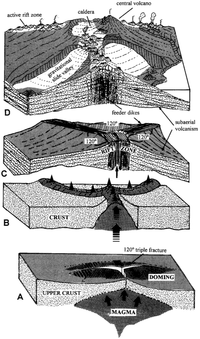
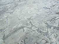
"Dike complexes, which are increasingly accepted as a common feature in the growth of most oceanic volcanoes, are well represented in the Canary Islands, where their deep structure can be readily observed through hundreds of infiltration galleries excavated for water mining."[2]
"Three-armed patterns [as in the diagram on the right] seem to be a common scheme in the arrangement of volcanic vents in oceanic volcanoes."[2]
Geology
Def. "the study of the planet earth- the materials it is made of, the processes that act on those materials, the products formed, and the history of the planet and its life forms since its origin"[3] is called geology.
With respect to volcanoes, the geology consists of the study of the materials they are made of, the processes that act on these materials, the products formed, and the history of these volcanoes and effects on life forms since each volcano's origin.
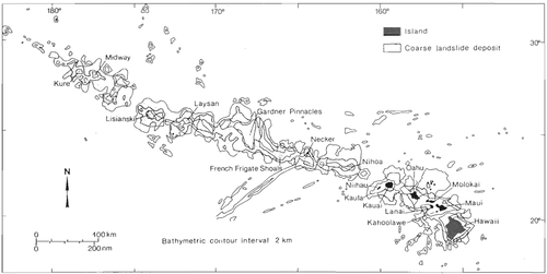
Above is a geographic distribution of large landslides adjoining the Hawaiian volcanoes. Sidescan "sonar surveys have shown that large landslides are ubiquitous around the submarine flanks of Hawaiian volcanoes [...] where basaltic shield volcanoes have collapsed after growing to volumes of about 20,000 km3 in subtropical climates on sediment-covered seafloor of Cretaceous age. [...] Tsunamis generated by landslides pose hazards also to other flanks and islands nearby (Moore and Moore 1984, 1988)."[4]
Radiation
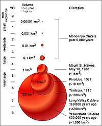
"The Volcanic Explosivity Index, or VEI, was proposed in 1982 as a way to describe the relative size or magnitude of explosive volcanic eruptions. It is a 0-to-8 index of increasing explosivity. Each increase in number represents an increase around a factor of ten. The VEI uses several factors to assign a number, including volume of erupted pyroclastic material (for example, ashfall, pyroclastic flows, and other ejecta), height of eruption column, duration in hours, and qualitative descriptive terms."[5]
"In the figure [on the right], the volumes of several past explosive eruptions and the corresponding VEI are shown. Numbers in parentheses represent total volume of erupted pyroclastic material (tephra, volcanic ash, and pyroclastic flows) for selected eruptions; the volumes are for uncompacted deposits. Each step increase represents a ten fold increase in the volume of erupted pyroclastic material."[5]
"A series of small to moderate explosive eruptions from Mono-Inyo Craters Volcanic Chain, California, during the past 5,000 years ranged from VEI of 1 to 3. The 18 May 1980 eruption of Mount St. Helens was a VEI 5 with an erupted volume of about 1 km3. The 1991 eruption of Mount Pinatubo had a volume of about 10 km3 and a VEI of 5 to 6. The 1815 eruption of Tambora, Indonesia, had a VEI of 7 and a volume in excess of 100 km3. The eruption of Long Valley Caldera about 760,000 years ago had a VEI of 7 and a volume of 600 km3 of material. The largest explosive eruption on the figure occurred at Yellowstone about 600,000 years ago with a VEI of 8 and a volume of about 1,000 km3 of material."[5]
"The VEI has some similarities to the Richter magnitude scale used to measure earthquakes. It has a simple numerical index of increasing magnitude of explosivity, with each interval representing an increase of about a factor of 10 in the volume of erupted tephra."[5]
"There are no known explosive events with a VEI larger than 8."[5]
The "amount of sulfur dioxide gas injected high into the atmosphere (which is not necessarily related to the size of an eruption) [is] a critical factor in determining the climatic impact of volcanic eruptions. [The] VEI is primarily used to estimate the relative size of an explosive eruption."[5]
"Large explosive eruptions occur much less frequently than small ones. Through 1994, the record of volcanic eruptions in the past 10,000 years maintained by the Global Volcanism Program of the Smithsonian Institution shows that there have been 4 eruptions with a VEI of 7, 39 of VEI 6, 84 of VEI 5, 278 of VEI 4, 868 of VEI 3, and 3,477 explosive eruptions of VEI 2."[5]
Planetary science
"In contrast to the Proterozoic, Archean rocks are often heavily metamorphized deep-water sediments, such as graywackes, mudstones, volcanic sediments and banded iron formations. Greenstone belts are typical Archean formations, consisting of alternating high- and low-grade metamorphic rocks. The high-grade rocks were derived from volcanic island arcs, while the low-grade metamorphic rocks represent deep-sea sediments eroded from the neighboring island arcs and deposited in a forearc basin. In short, greenstone belts represent sutured protocontinents.[6]"[7]
Colors
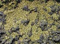
At right is a visual close up of green sand which is actually olivine crystals that have been eroded from lava rocks. Some olivine crystals are still inside the lava rock.
Volcanic minerals
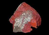
"Cinnabar ... or cinnabarite ... (red mercury(II) sulfide (HgS), native vermilion), is the common ore of mercury. [Its color is cochineal-red, towards brownish red and lead-gray] ... Cinnabar [may be] found in a massive, granular or earthy form and is bright scarlet to brick-red in color.[8] ... Generally cinnabar occurs as a vein-filling mineral associated with recent volcanic activity and alkaline hot springs. Cinnabar is deposited by epithermal ascending aqueous solutions (those near surface and not too hot) far removed from their igneous source."[9]
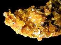
"Orpiment, [Arsenic trisulfide] As2S3, is a common monoclinic arsenic sulfide mineral. ... Orpiment is an orange to yellow mineral that is found worldwide [on Earth], and occurs as a sublimation product in volcanic fumaroles, low temperature hydrothermal veins, hot springs and as a byproduct of the decay of another arsenic mineral, realgar."[10]
Theoretical volcanoes
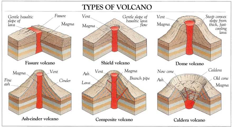

The diagram at top shows six theoretical types of volcanoes:
- fissure,
- shield,
- dome,
- ash-cinder,
- composite, and
- caldera.
The second diagram shows
- a compound and complex volcano,
- a composite volcano,
- a somma volcano with cone inside earlier cone,
- a caldera,
- a shield volcano, and remnants
- lava dome,
- fissure vent row of craters,
- a cinder cone profile,
- a tuff cone,
- a tuff ring, and
- a maar.
Def. a mountain or hill, typically conical, having a crater or vent through which lava, rock fragments, hot vapor, and gas are or have been erupted from the Earth's, or another astronomical object's crust is called a volcano.
Def. a "vent or fissure on the surface of a planet (usually in a mountainous form) with a magma chamber attached to the mantle of a planet or moon, periodically erupting forth lava and volcanic gases onto the surface"[11] is called a volcano.
"A volcano is a rupture on the crust of a planetary-mass object, such as Earth, that allows hot lava, volcanic ash, and gases to escape from a magma chamber below the surface."[12]
Def. a "powerful volcano, often having an explosive or cataclysmic eruption"[13] is called a supervolcano.
Entities
In the Mount Redoubt volcanic eruption in Alaska, is the entity of electromagnetism hanging the cloud of ash over the volcano?
Sources

"After two months of eruptions and six months of quakes and tremors, the underwater volcano off the coast of El Hierro appears to be quieting down. A mass of new crust has been building by tens to perhaps a hundred meters, but it is still nowhere near rising above the ocean surface and extending the Canary Island chain."[14]
"The Advanced Land Imager (ALI) on NASA’s Earth Observing-1 (EO-1) satellite captured this natural-color image of the island and its offshore eruption on December 16, 2011. The eruption is located about one kilometer south-southwest of the town of La Restinga."[14]
"The milky green swirls in the Atlantic Ocean are a volcanic brew of steaming lava fragments, bits of rock, heated gas, and other debris that are carried to the west and north by currents. Meanwhile, tremors have been occurring on the north side of the island at depths of 17 to 23 kilometers. Red circles mark the locations of three tremors reported on December 18. The white puffs over the island are clouds, not volcanic emissions."[14]
"El Hierro is a shield volcano growing along the southwestern edge of the ancient El Golfo volcano. El Golfo collapsed about 130,000 years ago, but the ruddy brown and rugged terrain of the island attests to many years of volcanism in the area. El Hierro last erupted in 1793, according to some historical records, and the area has the greatest concentration of young vents in the Canary Islands."[14]
Objects
"Greenstone belts are zones of variably metamorphosed mafic to ultramafic volcanic sequences with associated sedimentary rocks that occur within Archaean and Proterozoic cratons between granite and gneiss bodies."[15]
"The name comes from the green hue imparted by the colour of the metamorphic minerals within the mafic rocks. Chlorite, actinolite and other green amphiboles are the typical green minerals."[15]
"A greenstone belt is typically several dozens to several thousand kilometres long and although composed of a great variety of individual rock units, is considered a 'stratigraphic grouping' in its own right, at least on continental scales."[15]
""Greenstone belts" are distributed throughout geological history from the Phanerozoic Franciscan belts of California where blueschist, whiteschist and greenschist facies are recognised, through to the Palaeozoic greenstone belts of the Lachlan Fold Belt, Eastern Australia, and a multitude of Proterozoic and Archaean examples."[15]
"Archaean greenstones are found in the Slave craton, northern Canada, Pilbara craton and Yilgarn Craton, Western Australia, Gawler Craton in South Australia, and in the Wyoming Craton in the US. Examples are found in South and Eastern Africa, namely the Kaapvaal craton and also in the cratonic core of Madagascar, as well as West Africa and Brazil, northern Scandinavia and the Kola Peninsula (see Baltic Shield)."[15]
"Phanerozoic ophiolite belts and greenstone belts occur in the Franciscan Complex of south-western North America, within the Lachlan Fold Belt, the Gympie Terrane of Eastern Australia, the ophiolite belts of Oman and around the Guiana Shield."[15]
Volcanic activity
Volcanic activity may be activity from or by a volcano or activity from the sources of volcanoes.
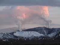
On Iceland this year there is an increase in volcanic activity as shown in the photo on the right.
"Our research makes the connection between recent accelerated uplift and the accelerated melting of the Icelandic ice caps."[16]
"There is actually geological evidence that during the past deglaciation about 12,000 years ago, volcanic activity in some regions of Iceland increased thirtyfold. In fact, some estimate that this uplift could increase the frequency of volcanic eruptions such as the 2010 eruption of Eyjafjallajokull, which had negative consequences worldwide."[17]
Tephra layers
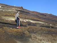
In the image on the right, the thick and light colored layer across the center of the photo is rhyolitic tephra from Hekla.
A tephra layer which bears its own unique chemistry and character may be used as a temporal marker horizon in archaeological and geological sites.
Yellows
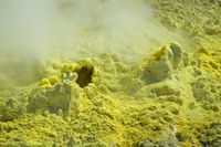
Def. "an area of volcanic activity that gives off sulfurous steam"[18] is called a solfatara.
Gaseous objects
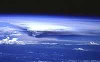
Def. a "cloud of tephra and gases that forms downwind of an erupting volcano"[19] is called an eruption cloud.
"Eruption cloud is often used interchangeably with plume or ash cloud."[19]
"The vertical pillar of tephra and gases rising directly above a vent is an eruption column."[19]
"Eruption clouds are often dark colored--brown to gray--but they can also be white, very similar to weather clouds. Eruption clouds may drift for thousands of kilometers downwind and often become increasingly spread out over a larger area with increasing distance from an erupting vent (note fan-shaped eruption cloud in [the photograph on the right]. Large eruption clouds can encircle the Earth within days."[19]
"The eruption column [on the right] rose to at least 18 km above sea level where the volcanic ash and gas were blown west to form a fan-shaped eruption cloud."[19]
Liquid objects
Def. "melted rock ejected by a volcano from its crater or fissured sides"[20] is called a lava.
Usage notes
"Geologists make a distinction between magma (molten rock underground) and lava (molten rock on the surface)."[20]
Def. "molten matter within the earth, the source of the material of lava flows, dikes of eruptive rocks, etc"[21] is called a magma.
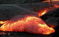
"Streams of molten rock that ooze from gaps or vents in the Earth’s surface are called lava flows. Though generally slow-moving, these rivers of rock pose a hazard to everything in their paths. They can bury or burn homes and roads, ruin farmland for generations, and transform glaciers into muddy landslides (lahars)."[22]
"Lava flows can take many shapes and move at very different rates depending on the viscosity of the magma, the slope of the land, and the rate of an eruption. Some of the speediest flows travel 60 kilometers (40 miles) per hour; the slowest creep along at less than 1 kilometer (0.6 miles) per hour. They can sometimes even flow for more than a year after an eruption has ended."[22]
"While viscous lava flows are defined by steep flow fronts and pressure ridges, low-viscosity lavas tend to move faster and create longer, narrower shapes. They also tend to have smaller flow fronts and levee-like structure along their edges. Many characteristics of a low-viscosity lava flow are visible in [the image on the right second down] of Zhupanovsky and Dzenzursky volcanoes on Russia’s Kamchatka Peninsula. The image was acquired by the Operational Land Imager (OLI) on the Landsat 8 satellite on September 9, 2013."[23]
"In the image, younger lava flows appear grey, while older flows are covered by green vegetation. The exact ages of the flows are unclear, but the eruptions that produced them likely occurred during the past few thousand years. Distinctive lava levees are visible along the edges of many of the younger flows. These features form as lava cools and hardens along the edges or top of a flow while the center of a flow still advances."[23]
"In comparison to the Chao dacite in Chile (the product of viscous lava), the flows at Zhupanovsky [at lowest right] and Dzenzursky are much narrower and longer. They have smaller flow fronts (10 to 30 meters tall) in comparison to the sheer 400-meter cliffs at Chao, as well as more prominent lava levees along the edges. Like Chao, the flows shown above have pressure ridges caused by the compression of the cooling top of the lava as the flow advanced."[23]
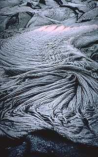
Def. a "form of lava flow of basaltic rock, usually dark-colored with a smooth or ropey surface"[24] is called pahoehoe.
"Ropy pahoehoe [shown in the fourth image down on the right, taken 11 June 1995] is the most common surface texture of pahoehoe flows. The numerous folds and wrinkles ("ropes") that are characteristic of ropy pahoehoe form when the thin, partially solidified crust of a flow is slowed or halted (for example, if the crust encounters an obstruction or slower-moving crust). Because lava beneath the crust continues to move forward, it tends to drag the crust along. The crust then behaves like an accordian that is squeezed together--the crust is flexible enough to develop wrinkles or a series of small ridges and troughs as it is compressed and driven forward."[25]
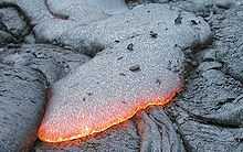
Def. a "form of lava flow [shown on the right, fifth image down] consisting of basaltic rock, usually dark-colored with a jagged and loose, clinkery surface"[26] is called an aa.
Volcanic rocks
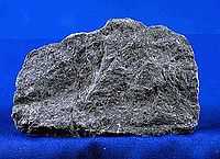
Def. a "hard mafic [...] rock of varied mineral content"[27] is called a basalt.
"Basalt is a hard, black volcanic rock with less than about 52 weight percent silica (SiO2). Because of basalt's low silica content, it has a low viscosity (resistance to flow). Therefore, basaltic lava can flow quickly and easily move > 20 km from a vent. The low viscosity typically allows volcanic gases to escape without generating enormous eruption columns. Basaltic lava fountains and fissure eruptions, however, still form explosive fountains hundreds of meters tall. Common minerals in basalt include olivine, pyroxene, and plagioclase. Basalt is erupted at temperatures between 1100 to 1250° C."[28]
"Basalt is the most common rock type in the Earth's crust (the outer 10 to 50 km). In fact, most of the ocean floor is made of basalt."[28]
"Huge outpourings of lava called "flood basalts" are found on many continents. The Columbia River basalts, erupted 15 to 17 million years ago, cover most of southeastern Washington and regions of adjacent Oregon and Idaho."[28]
"Basaltic magma is commonly produced by direct melting of the Earth's mantle, the region of the Earth below the outer crust. On continents, the mantle begins at depths of 30 to 50 km."[28]
"Shield volcanoes, such as those that make up the Islands of Hawai`i, are composed almost entirely of basalt."[28]
"Slate is a fine-grained, foliated, homogeneous metamorphic rock derived from an original shale-type sedimentary rock composed of clay or volcanic ash through low-grade regional metamorphism. It is the finest grained foliated metamorphic rock.[29] Foliation may not correspond to the original sedimentary layering, but instead is in planes perpendicular to the direction of metamorphic compression.[29] [...] Slate is frequently grey in color, especially when seen, en masse, covering roofs. However, slate occurs in a variety of colors even from a single locality; for example, slate from North Wales can be found in many shades of grey, from pale to dark, and may also be purple, green or cyan."[30]
Materials
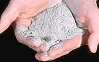
"Volcanic ash collected in Randle, Washington, [in the image on the right, is] located about 40 km NNE of Mount St. Helens."[31]
"The north edge of the eruption cloud of May 18, 1980, passed over Randle and deposited between 1 and 2 cm of ash on the community. At the same distance along the axis of the eruption cloud, however, about 7 cm of ash and larger-sized tepra fell to the ground."[31]
"Volcanic ash consists of rock, mineral, and volcanic glass fragments smaller than 2 mm (0.1 inch) in diameter, which is slightly larger than the size of a pinhead. Volcanic ash is not the same as the soft fluffy ash that results from burning wood, leaves, or paper. It is hard, does not dissolve in water, and can be extremely small--ash particles less than 0.025 mm (1/1,000th of an inch) in diameter are common."[31]
"Ash is extremely abrasive, similar to finely crushed window glass, mildly corrosive, and electrically conductive, especially when wet."[31]
"Volcanic ash is created during explosive eruptions by the shattering of solid rocks and violent separation of magma (molten rock) into tiny pieces. Explosive eruptions are generated when ground water is heated by magma and abruptly converted to steam and also when magma reaches the surface so that volcanic gases dissolved in the molten rock expand and escape (explode) into the air extremely rapidly. After being blasted into the air by expanding steam and other volcanic gases, the hot ash and gas rise quickly to form a towering eruption column directly above the volcano."[31]
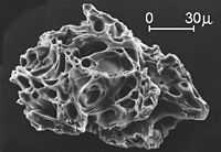
The second image down on the right is a close "view of a single ash particle from the eruption of Mount St. Helens; image is from a scanning electron microscope (SEM). The tiny voids or "holes" are called vesicles and were created by expanding gas bubbles during the eruption of magma."[31]
Human conditions
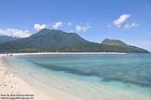
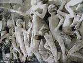
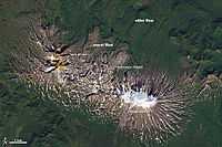
The location of Mt. Hibok-Hibok volcano imaged at the right is on the Camiguin Island in the Philippines. This eruption produced an ashflow, which killed about 500 people.
The eruption in 1951 produced pyroclastic material and lava on the December 4, 1951. This encased bodies in gray material. Most of the people were found as if they were just asleep.
Mercury
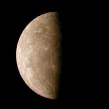
"A higher-reflectance, relatively red material occurs as a distinct class of smooth plains that were likely emplaced volcanically; a lower-reflectance material with a lesser spectral slope may represent a distinct crustal component enriched in opaque minerals, possibly more common at depth."[32]
"The distinctively red smooth plains (HRP) appear to be large-scale volcanic deposits stratigraphically equivalent to the lunar maria (20), and their spectral properties (steeper spectral slope) are consistent with magma depleted in opaque materials. The large areal extent (>106 km2) of the Caloris HRP is inconsistent with the hypothesis that volcanism was probably shallow and local (10); rather, such volcanism was likely a product of extensive partial melting of the upper mantle."[32]
"Despite the dearth of ferrous iron in silicates, Mercury's surface nonetheless darkens and reddens with time like that of the Moon. This darkening and reddening has been interpreted to be the result of production of nanophase iron (e.g., Pieters et al., 2000; Hapke, 2001), which could be derived from an opaque phase in the crustal material or from delivery by micrometeorite impacts (Noble and Pieters, 2003). On the Moon, deposits that are brighter and redder than the average Moon spectrum appear to be lower in iron (e.g., highland material); deposits that are darker and redder than average are higher in iron (e.g., low-Ti mare material) (Lucey et al., 1995)."[33]
Venus
"A portion of the eastern edge of Alpha Regio is displayed in this three-dimensional perspective view [on the right] of the surface of Venus. The viewpoint is located at approximately 30 degrees south latitude, 11.8 degrees east longitude at an elevation of 2.4 kilometers (3.8 miles). The view is to the northeast at the center of an area containing seven circular dome-like hills. The average diameter of the hills is 25 kilometers (15 miles) with maximum heights of 750 meters (2,475 feet). Three of the hills are visible in the center of the image. Fractures on the surrounding plains are both older and younger than the domes. The hills may be the result of viscous or thick eruptions of lava coming from a vent on the relatively level ground, allowing the lava to flow in an even lateral pattern. The concentric and radial fracture patterns on their surfaces suggests that a chilled outer layer formed, then further intrusion in the interior stretched the surface. An alternative interpretation is that domes are the result of shallow intrusions of molten lava, causing the surface to rise. If they are intrusive, then magma withdrawal near the end of the eruptions produced the fractures. The bright margins possibly indicate the presence of rock debris or talus at the slopes of the domes. Resolution of the Magellan data is about 120 meters (400 feet). Magellan's synthetic aperture radar is combined with radar altimetry to develop a three-dimensional map of the surface. A perspective view is then generated from the map. Simulated color and a process called radar-clinometry are used to enhance small-scale structures. The simulated hues are based on color images recorded by the Soviet Venera 13 and 14 spacecraft. The image was produced by the JPL Multimission Image Processing Laboratory."[34]
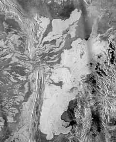
In the second image on the right is "a 225 meter per pixel Magellan radar image mosaic of Venus, centered at 47 degrees south latitude, 25 degrees east longitude in the Lada region. The scene is approximately 550 kilometers (341 miles) east-west by 630 kilometers (391 miles) north-south. The mosaic shows a system of east-trending radar-bright and dark lava flows encountering and breaching a north-trending ridge belt (left of center). Upon breaching the ridge belt, the lavas pool in a vast, radar-bright deposit (covering approximately 100,000 square kilometers [right side of image]). The source caldera for the lava flows, named Ammavaru, lies approximately 300 kilometers (186 miles) west of the scene."[35]
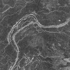
The third image down on the right is Magellan radar image of a lava channel on Venus. This unusually long channel ranges from Fortuna Tessera in the north down to the eastern Sedna Planitia in the south. The channel is about 2 km wide and shows branches and islands along its length. The framelet shown here is about 50 km wide, and north is up.
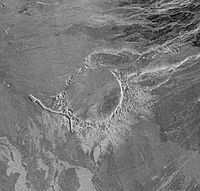
On the right, fourth image down, "Magellan's radar system detected few impact craters in the process of being resurfaced by volcanism. Alcott is the largest of these craters in transition, with a diameter of 63 km (39 mi). The trough-like depression (lower left) is a rille through which lava once flowed. A remnant of rough radial ejecta is preserved outside the crater's southeast rim. The presence of partially lava-flooded craters such as this is important to our understanding of the rate of resurfacing on Venus by volcanism."[36]
Earth
"Spectral properties of certain palagonitic soils found on Mauna Kea, Hawaii are similar to the spectral properties measured by earth-based telescopes for Martian soils [1,2,3]. ... Three layers with distinctly different colors (upper red, middle black, lower yellow) were sampled from hydrothermally altered basaltic tephra just below the summit of Mauna Kea."[37]
"The clay fractions (< 2 µm) of three palagonite samples-MK11 (red), MK12 (black), and MK13 (yellow) collected at an elevation of 4145 meters near the summit of Mauna Kea volcano in Hawaii ... The fine fractions of the black (MK12) and yellow (MK13) samples were similar to those of martian bright regions in terms of their overall shape."[38]
"Geologic evidence suggests that large amounts of water have likely flowed on Earth for the past 3.8 billion years—most of its existence. [It is b]elieved to have initially arrived on the surface through the emissions of ancient volcanoes".[39]
Moon
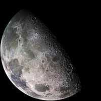
"Checking out the Galileo spacecraft's cameras during its December 1992 flyby of Earth's Moon, controllers took this dramatically illuminated picture [at right] through a violet filter. The view looks down on the Moon's north polar region with the Sun shining from the left at a low angle and the direction toward the moon's North pole toward the lower right. Across the image upper left stretches the smooth volcanic plain of the Mare Imbrium. Pythagoras crater, 65 miles wide, is near the center of the image -- mostly in shadow, its central peak just catches the sunlight. Yesterday, the Moon made its closest approach to Earth and was full for the second time in July (as reckoned by UT dates). The closest point in the Moon's orbit is referred to as Lunar Perigee, a mere 221,797 miles at 8 hours UT. The second full moon in a month is known as a "Blue Moon"."[40]
"There is ... a dearth of basalt compositions corresponding to differentiates of the yellow glasses. ... After olivine and chromite, differentiates of the Apollo 14 and 17 yellow glass magmas should differ only slightly in crystallization sequence. ... For green and yellow glasses, liquids are saturated only with olivine and chromite; for red and black glasses, negative slope represents liquids saturated with olivine and chromite, positive slope indicates olivine, chromite, and armalcolite."[41]
"Electron microprobe analyses indicate that the Apollo 15 red glasses with 13.8 wt.% TiO2 were produced in a volcanic fire-fountain. They are composed of three chemical groups connected by a pronounced trend. The liquidus phase relations are compatible with the view that the most Mg-rich group (A) was produced by partial melting of Ti-rich cumulates at a depth of about 480 km. The other red glasses (B and C) may have been derived from the group A magma by fractional crystallization at pressures less than 5 kbar."[42]
"During its mission, the Galileo spacecraft returned a number of images of Earth's only natural satellite. Galileo surveyed the moon on Dec. 7, 1992, on its way to explore the Jupiter system in 1995-1997."[43]
"This color mosaic was assembled from 18 images taken by Galileo's imaging system through a green filter. On the upperleft is the dark, lava-filled Mare Imbrium, Mare Serenitatis (middle left), Mare Tranquillitatis (lower left), and Mare Crisium, the dark circular feature toward the bottom of the mosaic. Also visible in this view are the dark lava plains of the Marginis and Smythii Basins at the lower right. The Humboldtianum Basin, a 400-mile impact structure partly filled with dark volcanic deposits, is seen at the center of the image."[43]
Mars
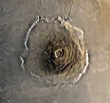
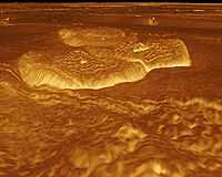
"The shield volcano, Olympus Mons [shown in the second image at right] (Mount Olympus), at 27 km is the second highest known mountain in the Solar System.[44] It is an extinct volcano in the vast upland region Tharsis, which contains several other large volcanoes. Olympus Mons is over three times the height of Mount Everest, which in comparison stands at just over 8.8 km.[45]"[46]
The Martian volcano Olympus Mons, meaning "Mount Olympus", is the tallest known mountain in the Solar System (standing about three times taller than Earth's Mount Everest.) Other large volcanoes are Ascraeus Mons, Pavonis Mons and Arsia Mons -- all of which lie in a nearly straight line.
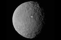
Ceres
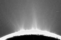
"Recent Cassini images of Saturn's moon Enceladus backlit by the sun show the fountain-like sources of the fine spray of material that towers over the south polar region. The image was taken looking more or less broadside at the "tiger stripe" fractures observed in earlier Enceladus images. It shows discrete plumes of a variety of apparent sizes above the limb of the moon."[47]
"The greatly enhanced and colorized image shows the enormous extent of the fainter, larger-scale component of the plume."[47]
Io
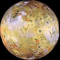
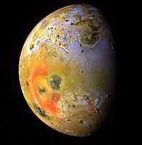

Io "is the innermost of the four Galilean moons of the planet Jupiter and, with a diameter of 3,642 kilometres (2,263 mi), the fourth-largest moon in the Solar System. ... With over 400 active volcanoes, Io is the most geologically active object in the Solar System.[48][49] ... Most of Io's surface is characterized by extensive plains coated with sulfur and sulfur dioxide frost. ... Io's volcanism is responsible for many of the satellite's unique features. Its volcanic plumes and lava flows produce large surface changes and paint the surface in various shades of yellow, red, white, black, and green, largely due to allotropes and compounds of sulfur."[50]
The second image at right is a "global view of Jupiter's moon, Io, ... obtained during the tenth orbit of Jupiter by NASA's Galileo spacecraft. Io, which is slightly larger than Earth's moon, is the most volcanically active body in the solar system. In this enhanced color composite, deposits of sulfur dioxide frost appear in white and grey hues while yellowish and brownish hues are probably due to other sulfurous materials. Bright red materials, such as the prominent ring surrounding Pele, and "black" spots with low brightness mark areas of recent volcanic activity and are usually associated with high temperatures and surface changes. One of the most dramatic changes is the appearance of a new dark spot (upper right edge of Pele), 400 kilometers (250 miles)in diameter which surrounds a volcanic center named Pillan Patera. The dark spot did not exist in images obtained 5 months earlier, but Galileo imaged a 120 kilometer (75 mile) high plume erupting from this location during its ninth orbit. North is to the top of the picture which was taken on September 19, 1997 at a range of more than 500,000 kilometers (310,000 miles) by the Solid State Imaging (SSI) system on NASA's Galileo spacecraft."[51]
The image at the third right is through the violet filter of the Voyager 1 Imaging Science Sub-system Wide-Angle Camera of the Masubi volcano on Jupiter's moon Io, acquired on March 5, 1979 at 14:37:29 UTC.
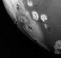
"The camera on Cassini captured images [fourth at the right] of eclipsed Io in several colors ranging from the near-ultraviolet to the near-infrared. A black-and-white movie clip of 48 clear-filter frames spanning two hours during the eclipse was released on February 5 (PIA02882). Here, two colors have been added to show the type of evidence used by imaging scientists in determining the source of Io's auroral glows. The color pictures were taken at lower resolution -- 120 kilometers (75 miles) per pixel rather than 60 kilometers(37 miles) per pixel -- and less frequently than the clear-filter images. White dots near the equator are volcanoes, some of which are much brighter than the faint atmospheric glows. The brightest of them is the volcano Pele."[52]
"Emissions of light (at wavelengths of 595 to 645 nanometers) likely arise from a tenuous atmosphere of oxygen. These glows would appear red to the eye and are consequently colored red in the movie. Emissions in near-ultraviolet wavelengths (between 300 and 380 nanometers), corresponding wavelength to the bright blue visible glows one would expect from sulfur dioxide. They have been colored blue in the movie. The blue glows are restricted to areas deep down in the atmosphere near the surface of Io, while the red glows are much more extensive, reaching heights of up to 900 kilometers (560 miles). This would be expected if the blue glows are indeed produced by sulfur dioxide, since sulfur dioxide molecules are heavier than oxygen atoms, so are more closely bound to the surface by gravity. The prominent blue and red regions near the equator of Io dance across the moon with the changing orientation of Jupiter's magnetic field, illustrating the relationship between Io's auroras and the electric currents that excite them."[52]
"A faint blue emission is visible near the north pole of Io, possibly due to a volcanic plume erupting from the volcano Tvashtar at high northern latitude on the side of Io opposite Cassini. This eruption, observed by both Galileo and Cassini, left an enormous red ring around Tvashtar, visible in image PIA02588, released on March 29, 2001."[52]
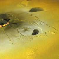
"An active volcanic eruption on Jupiter's moon Io was captured in this image taken on February 22, 2000 by NASA's Galileo spacecraft. Tvashtar Catena, a chain of giant volcanic calderas centered at 60 degrees north, 120 degrees west, was the location of an energetic eruption caught in action in November 1999. A dark, "L"-shaped lava flow to the left of the center in this more recent image marks the location of the November eruption. White and orange areas on the left side of the picture show newly erupted hot lava, seen in this false color image because of infrared emission. The two small bright spots are sites where molten rock is exposed to the surface at the toes of lava flows. The larger orange and yellow ribbon is a cooling lava flow that is more than more than 60 kilometers (37 miles) long. Dark, diffuse deposits surrounding the active lava flows were not there during the November 1999 flyby of Io."[53]
"This color mosaic was created by combining images taken in the near-infrared, clear, and violet filters from Galileo's camera. The range of wavelengths is slightly more than that of the human eye. The mosaic has been processed to enhance subtle color variations. The bright orange, yellow, and white areas at the left of the mosaic use images in two more infrared filters to show temperature variations, orange being the coolest and white the hottest material. This picture is about 250 kilometers (about 155 miles) across. North is toward the top and illumination from the Sun is from the west (left)."[53]
The electrical surroundings of Io provide another source of energy comparable with that of the gravitational tides.[54]
A current of 5 x 10⁶ Amps is shunted across flux tubes of the Jovian field by the presence of Io.[55]
When currents through Io are large enough to cause ohmic heating, these currents contract down to narrow paths which can be kept hot, and along which the conductivity is high.[55]
Tidal heating ensures that the interior of Io has a very low electrical resistance, causing a negligible extra amount of heat to be deposited by this current.[55]
The outermost layers, kept cool by radiation into space present a large resistance and result in a concentration of current into hotspots.[55]
Rock resistance and contact resistance contribute to generate high temperatures on the surface.[55]
These are the conditions of electric arcs that can produce temperatures up to ionization levels, several thousand K.[55]
The outbursts seen on the surface may also be the result of large current flowing in and out of the domain of Io.[55]
Most current spots are likely to be volcanic calderas, provided by tectonic events or generated by the current heating itself.[55]
As in electric arcs, very high temperatures locally evaporate material into gas hot enough to expand at a speed of ~1 km/s.[55]
X-ray emission may occur from the current spots.[55]
"A strictly periodic behavior would then be expected."[55]
Enceladus
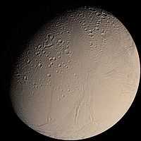
"This color Voyager 2 image mosaic shows the water-ice-covered surface of Enceladus, one of Saturn's icy moons. Enceladus' diameter of just 500 km would fit across the state of Arizona, yet despite its small size Enceladus exhibits one of the most interesting surfaces of all the icy satellites. Enceladus reflects about 90% of the incident sunlight (about like fresh-fallen snow), placing it among the most reflective objects in the Solar System. Several geologic terrains have superposed crater densities that span a factor of at least 500, thereby indicating huge differences in the ages of these terrains. It is possible that the high reflectivity of Enceladus' surface results from continuous deposition of icy particles from Saturn's E-ring, which in fact may originate from icy volcanoes on Enceladus' surface. Some terrains are dominated by sinuous mountain ridges from 1 to 2 km high (3300 to 6600 feet), whereas other terrains are scarred by linear cracks, some of which show evidence for possible sideways fault motion such as that of California's infamous San Andreas fault. Some terrains appear to have formed by separation of icy plates along cracks, and other terrains are exceedingly smooth at the resolution of this image. The implication carried by Enceladus' surface is that this tiny ice ball has been geologically active and perhaps partially liquid in its interior for much of its history. The heat engine that powers geologic activity here is thought to be elastic deformation caused by tides induced by Enceladus' orbital motion around Saturn and the motion of another moon, Dione."[56]
The third lower image on the right shows geyser emissions from the surface of Enceladus.
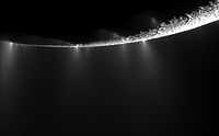
"Dramatic plumes, both large and small, spray water ice out from many locations along the famed "tiger stripes" near the south pole of Saturn's moon Enceladus. The tiger stripes are fissures that spray icy particles, water vapor and organic compounds."[57]
"More than 30 individual jets of different sizes can be seen in this image and more than 20 of them had not been identified before. At least one jet spouting prominently in previous images now appears less powerful."[57]
"This mosaic [third lower image on the right] was created from two high-resolution images that were captured by the narrow-angle camera when NASA's Cassini spacecraft flew past Enceladus and through the jets on Nov. 21, 2009."[57]
"The south pole of the moon lies near the limb in the top left quadrant of the mosaic, near the large jet that is second from left. Lit terrain seen here is on the leading hemisphere of Enceladus (504 kilometers, 313 miles across)."[57]
"The view was obtained at a distance of approximately 14,000 kilometers (9,000 miles) from Enceladus and at a sun-Enceladus-spacecraft, or phase, angle of 145 degrees. Image scale is 81 meters (267 feet) per pixel."[57]
"Recent Cassini images of Saturn's moon Enceladus backlit by the sun show the fountain-like sources of the fine spray of material that towers over the south polar region. The image was taken looking more or less broadside at the "tiger stripe" fractures observed in earlier Enceladus images. It shows discrete plumes of a variety of apparent sizes above the limb of the moon."[58]
"The greatly enhanced and colorized image shows the enormous extent of the fainter, larger-scale component of the plume."[58]
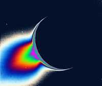
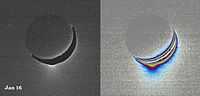
Five down on the right is a pair of images showing "[a] fine spray of small, icy particles emanating from the warm, geologically unique province surrounding the south pole of Saturn’s moon Enceladus[. It] was observed in a Cassini narrow-angle camera image of the crescent moon taken on Jan. 16, 2005. Taken from a high-phase angle of 148 degrees -- a viewing geometry in which small particles become much easier to see -- the plume of material becomes more apparent in images processed to enhance faint signals [right image of the pair]."[59]
"Though the measurements of particle abundance are more certain within 100 kilometers (60 miles) of the surface, the values measured there are roughly consistent with the abundance of water ice particles measured by other Cassini instruments (reported in September, 2005) at altitudes as high as 400 kilometers (250 miles) above the surface."[59]
"The image at the left was taken in visible green light. A dark mask was applied to the moon's bright limb in order to make the plume feature easier to see."[59]
"The image at the right has been color-coded to make faint signals in the plume more apparent. Images of other satellites (such as Tethys and Mimas) taken in the last 10 months from similar lighting and viewing geometries, and with identical camera parameters as this one, were closely examined to demonstrate that the plume towering above Enceladus' south pole is real and not a camera artifact. The images were acquired at a distance of about 209,400 kilometers (130,100 miles) from Enceladus. Image scale is about 1 kilometer (0.6 mile) per pixel."[59]
Triton
"This false color image of Triton is a composite of images taken through the violet, green and ultraviolet filters. The image was taken early on Aug. 25, 1989 when Voyager 2 was about 190,000 kilometers (118,000 miles) from Triton's surface. The smallest visible features are about 4 kilometers (2.5 miles) across. The image shows a geologic boundary between completely dark materials and patchy light/dark materials. A layer of pinkish material stretches across the center of the image. The pinkish layer must be thin because underlying albedo patterns show through. Several features appear to be affected by the thin atmosphere; the elongated dark streaks may represent particulate materials blown in the same direction by prevailing winds, and the white material may be frost deposits. Other features appear to be volcanic deposits including the smooth, dark materials alongside the long, narrow canyons. The streaks themselves appear to originate from very small circular sources, some of which are white, like the source of the prominent streak near the center of the image. The sources may be small volcanic vents with fumarolic-like activity. The colors may be due to irradiated methane, which is pink to red, and nitrogen, which is white."[60]
Sedimentary volcanoes
Def. "sedimentary features [...] that display a similar shape as volcanoes"[61] are called sedimentary volcanoes.
"Sedimentary volcanoes have several characteristics in common with "classical" volcanoes, including their shapes and the processes that contribute to their genesis [...] three main types of sedimentary volcanoes and associated structures [include]: mud volcanoes, sand volcanoes, and escape structures."[61]
"The Conical Seamount in the forearc of the Marianas Arc, which has been found to be a mud volcano, is even larger, reaching 25 km in diameter and 2 km in height (White, 2005). Wherever deep-sea mud volcanoes are mentioned, they are commonly associated with seepings of gas [...], not rarely along faults affecting the sea bottom [...]."[61]
"Like "true" volcanoes, which build up because magma is pushed upward from a magma chamber with subsequent outflow of lava, most deep-sea mud volcanoes form under conditions when sedimentary particles are pushed upward together with gases and/or liquids (commonly water as the liquid, and air or hydrocarbons as gas) from a reservoir in the subsoil. This mixture follows an upward pathway (which may or may not represent a zone of relative weakness) and flows out at the sedimentary surface as a commonly low-viscosity material [...] that spreads out like a shield volcano. [...] thick piles of extruded material form, more or less as a stratovolcano, probably because a significant amount of already somewhat consolidated mud is included in the outflowing mass with a high particle-gas-and liquid ratio."[61]
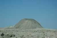
On the right is a mud volcano in Sistan and Baluchestan, Iran.
Volcanism
Def. any remnants "of the natural phenomena and processes associated with the action of volcanos, geysers and fumaroles"[62], especially any remnants of past volcanic activity, are called volcanism.
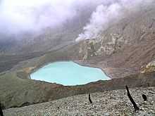
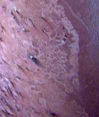
The image on the left shows relative relief around Campi Flegrei. This emphasizes that most or all of the relief is due to remnants of volcanic activity.
Def.
- any "of several impure clay minerals consisting mostly of montmorillonite"[63] or
- a "porous clay formed by the decomposition of volcanic ash that swells 5 to 6 times its original volume in the presence of water"[64]
is called a bentonite.
Bentonites of definition 2 are volcanism, or remnants of volcanic activity, even though they are metamorphic sediments or rocks.
Def. a "clay of the illite group that contains potassium and is formed by alteration of volcanic ash"[65] is called potassium bentonite, K bentonite, or potash bentonite.
Volcanicity
Def. the "level of power of a volcano"[66] is called its volcanicity.
Research
Hypothesis:
- The origin of volcanoes on Earth may be of the same sort as their origin on Io.
Control groups

The findings demonstrate a statistically systematic change from the status quo or the control group.
“In the design of experiments, treatments [or special properties or characteristics] are applied to [or observed in] experimental units in the treatment group(s).[67] In comparative experiments, members of the complementary group, the control group, receive either no treatment or a standard treatment.[68]"[69]
A control group for volcanoes would contain one or more volcanoes as standards.
Proof of concept
Def. a “short and/or incomplete realization of a certain method or idea to demonstrate its feasibility"[70] is called a proof of concept.
Def. evidence that demonstrates that a concept is possible is called proof of concept.
The proof-of-concept structure consists of
- background,
- procedures,
- findings, and
- interpretation.[71]
See also
- Air Quality
- Asama,Japan Volcanic eruption
- Cameroon
- Campi Flegrei
- Costa Rica
- El Chichon, Mexico Volcano
- Fiji
- Hibok-Hibok Volcano
- Iceland
- Igneous rocks
- Io
- Komagatake, japan 1640
- Krakatau, Indonesia Volcano
- Laki, Iceland Volcano
- Mars
- Mount Cotopaxi, Ecuador Valcano
- Mount Pelee, Martinique Volcano
- Mount Rainier
- Mount Tambora
- Mount Unzen, Japan 1792
- Mount Vesuvius
- Mt. Vesuvius
- New Zealand
- Oshima, Japan Volcano
- Papandayan Volcano
- Pinatubo,Philippines Volcano
- Ruiz, Colombia Volcano
- Sciences
- Mount Somma
- St. Kitts and Nevis
- Titan
- Controversies in Science/What killed the dinosaurs
References
- ↑ Edgardo Cañón-Tapia and Alexandru Szakács (19 August 2010). Edgardo Cañón-Tapia and Alexandru Szakács. ed. Introduction, In: What Is a Volcano?. Geological Society of America. pp. 140. ISBN 9780813724706. http://rock.geosociety.org/Store/detail.aspx?id=SPE470. Retrieved 2015-03-17.
- 1 2 J.C. Carracedo (May 1994). "The Canary Islands: an example of structural control on the growth of large oceanic-island volcanoes". Journal of Volcanology and Geothermal Research 60 (3-4): 225-41. doi:10.1016/0377-0273(94)90053-1. http://www.geo.arizona.edu/~andyf/LaPalma/Canary%20Island%20Volcanism.pdf. Retrieved 2015-03-26.
- ↑ Justin Gould (July 18, 2012). "Earthquake Glossary - geology". Menlo Park, California USA: USGS. Retrieved 2014-12-03.
- ↑ Robin T. Holcomb and Roger C. Searle (1991). "Large Landslides from Oceanic Volcanoes". Marine Geotechnology 10: 19-32. http://www.geo.mtu.edu/EHaz/VolcanoInstability_class/pdf/clague/Holcomb%26Searle.pdf. Retrieved 2015-03-26.
- 1 2 3 4 5 6 7 C. G. Newhall and S. Self (29 December 2009). "VHP Photo Glossary: VEI". Menlo Park, California USA: United States Geological Survey. Retrieved 2015-02-28.
- ↑ Stanley 1999, pp. 302–303
- ↑ "Geological history of Earth, In: Wikipedia". San Francisco, California: Wikimedia Foundation, Inc. December 21, 2012. Retrieved 2013-01-22.
- ↑ R. J. King (2002). "Minerals Explained 37: Cinnabar". Geology Today 18 (5): 195–9. doi:10.1046/j.0266-6979.2003.00366.x.
- ↑ "Cinnabar, In: Wikipedia". San Francisco, California: Wikimedia Foundation, Inc. July 24, 2013. Retrieved 2013-07-30.
- ↑ "Orpiment, In: Wikipedia". San Francisco, California: Wikimedia Foundation, Inc. May 17, 2013. Retrieved 2013-09-16.
- ↑ "volcano, In: Wiktionary". San Francisco, California: Wikimedia Foundation, Inc. 13 February 2015. Retrieved 2015-03-01.
- ↑ "Volcano, In: Wikipedia". San Francisco, California: Wikimedia Foundation, Inc. 20 February 2015. Retrieved 2015-03-01.
- ↑ "supervolcano, In: Wiktionary". San Francisco, California: Wikimedia Foundation, Inc. 19 September 2013. Retrieved 2015-03-02.
- 1 2 3 4 Michael Carlowicz (December 16, 2011). "Tremors, Eruption at El Hierro Subsiding?". NASA Earth Observatory. Retrieved 2012-07-22.
- 1 2 3 4 5 6 "Greenstone belt, In: Wikipedia". San Francisco, California: Wikimedia Foundation, Inc. January 10, 2013. Retrieved 2013-01-22.
- ↑ Kathleen Compton (30 January 2015). "Melting Glaciers is Causing Iceland to Rise and May Increase Volcanic Activity". Iceland: Science World Report. Retrieved 2015-03-27.
- ↑ Catherine Griffin (30 January 2015). "Melting Glaciers is Causing Iceland to Rise and May Increase Volcanic Activity". Iceland: Science World Report. Retrieved 2015-03-27.
- ↑ SemperBlotto (22 February 2006). "solfatara, In: Wiktionary". San Francisco, California: Wikimedia Foundation, Inc. Retrieved 2015-03-03.
- 1 2 3 4 5 Space Shuttle astronauts (29 September 2014). "VHP Photo Glossary: Eruption Clouds". Menlo Park, California USA: USGS. Retrieved 2015-03-08.
- 1 2 "lava, In: Wiktionary". San Francisco, California: Wikimedia Foundation, Inc. 25 January 2011. Retrieved 2015-02-17.
- ↑ "magma, In: Wiktionary". San Francisco, California: Wikimedia Foundation, Inc. 29 December 2014. Retrieved 2015-02-17.
- 1 2 Erik Klemetti and Adam Voiland (21 November 2013). "The Shapes that Lavas Take, Part 1". Washington, DC USA: NASA. Retrieved 2015-02-18.
- 1 2 3 Erik Klemetti and Adam Voiland (22 November 2013). "The Shapes that Lavas Take, Part 2". Washington, DC USA: NASA. Retrieved 2015-02-18.
- ↑ "pahoehoe, In: Wiktionary". San Francisco, California: Wikimedia Foundation, Inc. 31 July 2014. Retrieved 2015-02-18.
- ↑ Tari Noelani Mattox (04 September 2000). "Photo glossary of volcano terms". Menlo Park, California, USA: U.S. Geological Survey. Retrieved 2015-02-18.
- ↑ "aa, In: Wiktionary". San Francisco, California: Wikimedia Foundation, Inc. 16 January 2015. Retrieved 2015-02-19.
- ↑ "basalt, In: Wiktionary". San Francisco, California: Wikimedia Foundation, Inc. 21 January 2015. Retrieved 2015-02-09.
- 1 2 3 4 5 Volcano Hazards Program (30 March 2014). "VHP Photo Glossary: Basalt". U.S. Geological Survey. Retrieved 2015-02-19.
- 1 2 Essentials of Geology, 3rd Ed, Stephen Marshak
- ↑ "Slate, In: Wikipedia". San Francisco, California: Wikimedia Foundation, Inc. October 16, 2013. Retrieved 2013-10-18.
- 1 2 3 4 5 6 D.E. Wieprecht (18 May 1980). "VHP Photo Glossary: volcanic ash". Menlo Park, California USA: USGS. Retrieved 2015-03-09.
- 1 2 Mark S. Robinson, Scott L. Murchie, David T. Blewett, Deborah L. Domingue, S. Edward Hawkins III, James W. Head, Gregory M. Holsclaw, William E. McClintock, Timothy J. McCoy, Ralph L. McNutt Jr., Louise M. Prockter, Sean C. Solomon, Thomas R. Watters (July 4, 2008). "Reflectance and Color Variations on Mercury: Regolith Processes and Compositional Heterogeneity". Science 321 (5885): 66-9. doi:10.1126/science.1160080. http://www.sciencemag.org/content/321/5885/66.short. Retrieved 2013-07-28.
- ↑ Laura Kerber, James W. Head, Sean C. Solomon, Scott L. Murchie, David T. Blewett, Lionel Wilson (2009). [http://www.sciencedirect.com/science/article/pii/S0012821X09002611 "Explosive volcanic eruptions on Mercury: Eruption conditions, magma volatile content, and implications for interior volatile abundances"]. Earth and Planetary Science Letters 285: 263-71. doi:10.1016/j.epsl.2009.04.037. http://www.sciencedirect.com/science/article/pii/S0012821X09002611. Retrieved 2013-07-28.
- ↑ Eric De Jong, Jeff Hall, Myche McAuley, and Randy Kirk (13 March 1996). "PIA00246: Venus - 3D Perspective View of Eastern Edge of Alpha Regio". Pasadena, California USA: NASA/JPL. Retrieved 2015-02-03.
- ↑ Sue Lavoie (14 November 1996). "PIA00486: Venus - System of Lava Flows and Ridge Belt". Pasadena, California USA: NASA/JPL. Retrieved 2015-02-04.
- ↑ Dan Crichton, Betty Sword, and Colleen Schroeder (10 May 2005). "Craters in Transition". Pasadena, California USA: NASA/JPL. Retrieved 2015-02-04.
- ↑ D. C. Golden, R. V. Morris, D. W. Ming, R. K. Vempati, and H. V. Lauer (March 1991). "Mineralogy of Palagonitic Soils from Hawaii". Abstracts of the Lunar and Planetary Science Conference 22 (03): 449-50. http://adsabs.harvard.edu/abs/1991LPI....22..449G. Retrieved 2013-09-14.
- ↑ D. C. Golden, D. W. Ming, R. V. Morris and H. V. Lauer Jr. (December 1992). Mars surface weathering products and spectral analogs: Palagonites and synthetic iron minerals, In: Workshop on the Martian Surface and Atmosphere Through Time". Lunar and Planetary Institute. pp. 59-60. http://adsabs.harvard.edu/full/1992msat.work...59G. Retrieved 2013-09-15.
- ↑ Steve Graham, Claire Parkinson, and Mous Chahine (October 1, 2010). "The Water Cycle". Washington, DC USA: NASA. Retrieved 2013-05-29.
- ↑ Robert Nemiroff & Jerry Bonnell (July 31, 1996). "Astronomy Picture of the Day". Washington, DC USA: NASA. Retrieved 2013-04-01.
- ↑ J. Longhi (1990). John W. Delano and Grant H. Heiken. ed. Differentiates of the Picritic Glass Magmas: The Missing Mare Basalts, In: Workshop on Lunar Volcanic Glasses: Scientific and Resource Potential. 3303 NASA Road 1, Houston, TX 77058 USA: Lunar and Planetary Institute. pp. 46-7. http://adsabs.harvard.edu/full/1990lgvp.work...46L. Retrieved 2013-09-15.
- ↑ J. W. Delano (1980). Chemistry and liquidus phase relations of Apollo 15 red glass Implications for the deep lunar interior, In: Lunar and Planetary Science Conference. 1. New York: Pergamon Press. pp. 251-88. Bibcode: 1980LPSC...11..251D. http://adsabs.harvard.edu/abs/1980LPSC...11..251D. Retrieved 2013-08-02.
- 1 2 Yvette Smith (December 8, 2009). "Earth's Moon". NASA. Retrieved 2012-07-22.
- ↑ Craig Glenday (2009). Guinness World Records. Random House, Inc.. p. 12. ISBN 0-553-59256-4.
- ↑ Junyong Chen, et al. (2006). "Progress in technology for the 2005 height determination of Qomolangma Feng (Mt. Everest)". Science in China Series D: Earth Sciences 49 (5): 531–8. doi:10.1007/s11430-006-0531-1.
- ↑ Mars, In: Wikipedia. San Francisco, California: Wikimedia Foundation, Inc. March 31, 2013. http://en.wikipedia.org/wiki/Mars. Retrieved 2013-03-31.
- 1 2 Sue Lavoie (9 March 2006). "PIA07759: Fountains of Enceladus - Image #2". Pasadena, California USA: NASA/JPL. Retrieved 2015-03-02.
- ↑ Rosaly MC Lopes (2006). "Io: The Volcanic Moon". In Lucy-Ann McFadden, Paul R. Weissman, Torrence V. Johnson. Encyclopedia of the Solar System. Academic Press. pp. 419–431. ISBN 978-0-12-088589-3.
- ↑ Lopes, R. M. C.; et al. (2004). "Lava lakes on Io: Observations of Io’s volcanic activity from Galileo NIMS during the 2001 fly-bys". Icarus 169 (1): 140–174. doi:10.1016/j.icarus.2003.11.013.
- ↑ "Io (moon), In: Wikipedia". San Francisco, California: Wikimedia Foundation, Inc. June 7, 2012. Retrieved 2012-06-08.
- ↑ "File:PIA01667-Io's Pele Hemisphere After Pillan Changes.jpg, In: Wikimedia Commons". San Francisco, California: Wikimedia Foundation, Inc. September 15, 2010. Retrieved 2012-07-17.
- 1 2 3 Sue Lavoie (May 31, 2001). "PIA03450: Io Color Eclipse Movie". Tucson, Arizona USA: NASA/JPL/University of Arizona. Retrieved 2013-05-30.
- 1 2 Sue Lavoie (May 31, 2000). "PIA02550: Ongoing Volcanic Eruption at Tvashtar Catena, Io". Pasadena, California USA: NASA/JPL. Retrieved 2014-03-04.
- ↑ Norman F. Ness, Mario H. Acuna, Ronald P. Lepping, Leonard F. Burlaga, Kenneth W. Behannon, and Fritz M. Neubauer (June 1979). "Magnetic Field Studies at Jupiter by Voyager 1: Preliminary Results". Science 204 (4396): 982-7. doi:10.1126/science.204.4396.982. http://www.sciencemag.org/content/204/4396/982.short. Retrieved 2015-03-01.
- 1 2 3 4 5 6 7 8 9 10 11 Thomas Gold (November 1979). "Electrical Origin of the Outbursts on Io". Science 206 (4422): 1071-3. doi:10.1126/science.206.4422.1071. http://www.sciencemag.org/content/206/4422/1071.short. Retrieved 2015-03-01.
- ↑ NASA/JPL/USGS (June 4, 1998). "PIA00347: Voyager 2 Color Image of Enceladus, Almost Full Disk". Reston, Virginia USA: NASA/JPL/USGS. Retrieved 2013-04-02.
- 1 2 3 4 5 Brian Dunbar (23 February 2010). "Bursting at the Seams". Retrieved 2015-03-02.
- 1 2 Sue Lavoie (9 March 2006). "PIA07759: Fountains of Enceladus - Image #2". Pasadena, California USA: NASA/JPL. Retrieved 2015-03-02.
- 1 2 3 4 Sue Lavoie (November 28, 2005). "PIA07760: Spray Above Enceladus". Pasadena, California: NASA and the Jet Propulsion Laboratory, California Institute of Technology. Retrieved 2012-07-22.
- ↑ Karen Boggs (August 20, 1999). "PIA02214: Triton". Pasadena, California USA: NASA/JPL. Retrieved 2013-03-31.
- 1 2 3 4 A. J. van Loon (19 August 2010). Edgardo Cañón-Tapia and Alexandru Szakács. ed. Sedimentary volcanoes: Overview and implications for the definition of a volcano on Earth, In: What is a Volcano?. Geological Society of America. pp. 140. ISBN 9780813724706. http://rock.geosociety.org/Store/detail.aspx?id=SPE470. Retrieved 2015-03-17.
- ↑ SemperBlotto (5 July 2007). "volcanism, In: Wiktionary". San Francisco, California: Wikimedia Foundation, Inc. Retrieved 2015-03-20.
- ↑ SemperBlotto (8 June 2006). "bentonite, In: Wiktionary". San Francisco, California: Wikimedia Foundation, Inc. Retrieved 2015-03-23.
- ↑ Help1for1roof (8 July 2014). "bentonite, In: Wiktionary". San Francisco, California: Wikimedia Foundation, Inc. Retrieved 2015-03-23.
- ↑ McGraw-Hill Science & Technology Dictionary (1974). "potassium bentonite". Answers.com. Retrieved 2015-03-23.
- ↑ Borganised (23 October 2008). "volcanicity, In: Wiktionary". San Francisco, California: Wikimedia Foundation, Inc. Retrieved 2015-03-21.
- ↑ Klaus Hinkelmann, Oscar Kempthorne (2008). Design and Analysis of Experiments, Volume I: Introduction to Experimental Design (2nd ed.). Wiley. ISBN 978-0-471-72756-9. http://books.google.com/?id=T3wWj2kVYZgC&printsec=frontcover.
- ↑ R. A. Bailey (2008). Design of comparative experiments. Cambridge University Press. ISBN 978-0-521-68357-9. http://www.cambridge.org/uk/catalogue/catalogue.asp?isbn=9780521683579.
- ↑ "Treatment and control groups, In: Wikipedia". San Francisco, California: Wikimedia Foundation, Inc. May 18, 2012. Retrieved 2012-05-31.
- ↑ "proof of concept, In: Wiktionary". San Francisco, California: Wikimedia Foundation, Inc. November 10, 2012. Retrieved 2013-01-13.
- ↑ Ginger Lehrman and Ian B Hogue, Sarah Palmer, Cheryl Jennings, Celsa A Spina, Ann Wiegand, Alan L Landay, Robert W Coombs, Douglas D Richman, John W Mellors, John M Coffin, Ronald J Bosch, David M Margolis (August 13, 2005). "Depletion of latent HIV-1 infection in vivo: a proof-of-concept study". Lancet 366 (9485): 549-55. doi:10.1016/S0140-6736(05)67098-5. http://www.ncbi.nlm.nih.gov/pmc/articles/PMC1894952//pii/S0140673605670985. Retrieved 2012-05-09.
External links
- African Journals Online
- Bing Advanced search
- Google Books
- Google scholar Advanced Scholar Search
- International Astronomical Union
- JSTOR
- Lycos search
- NASA's National Space Science Data Center
- NCBI All Databases Search
- Office of Scientific & Technical Information
- PsycNET
- PubChem Public Chemical Database
- Questia - The Online Library of Books and Journals
- SAGE journals online
- The SAO/NASA Astrophysics Data System
- Scirus for scientific information only advanced search
- SIMBAD Astronomical Database
- SIMBAD Web interface, Harvard alternate
- Spacecraft Query at NASA.
- SpringerLink
- Taylor & Francis Online
- USGS Photo Glossary of Volcanic Terms.
- WikiDoc The Living Textbook of Medicine
- Wiley Online Library Advanced Search
- Yahoo Advanced Web Search
| |||||||||||||||||||||||||||||||||||||||||||||||||||||
| ||||||||||||||||||||||||||||||||||||||
| |||||||||||||||||||||||||||||||||||
![]() This is a research project at http://en.wikiversity.org
This is a research project at http://en.wikiversity.org
| |
Development status: this resource is experimental in nature. |
| |
Resource type: this resource is an article. |
| |
Resource type: this resource contains a lecture or lecture notes. |
| |
Subject classification: this is a Geology resource. |