Structural geology
"Structural Geology [as a science is] a unified and integrated approach to the description and interpretation of deformation in the earth's crust, ranging from the microscopic scale, through mesoscopic structures, and up to the largest scale plate tectonic and orogenic structures."[1]
Theoretical structural geology
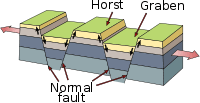
Lateral tension on rigid rock strata may produce a horst and graben structure.
Faults

Def. a "fracture in a rock formation causing a discontinuity"[2] is called a fault.
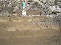
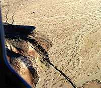
"Possibly the most obvious fault line in Britain. The red rock with reduction horizons is Triassic Merica mudstone (MMS), to the left is Jurassic interbedded marls and muds (with evapourites like gypsum). You can tell this is a normal fault because the Jurassic strata is younger than the MMS. This means the Jurassic strata has slid downwards to sit beside the MMS. Also near the fault in the MMS the lighter reduction horizons are dipping downwards probably due to marginal drag. The line of the fault runs along the beach, shown by the rock/sand divide."[3]
Active faults
Def. a "fault that is likely to have another earthquake sometime in the future"[4] is called an active fault.
"Faults are commonly considered to be active if they have moved one or more times in the last 10,000 years."[4]
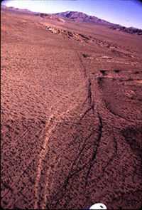
Thrust faults
"When Brúarjökull surged, large ice-marginal moraines which can be traced over many kilometers, were produced in front of the glacier. Todtmann (1952, 1955) identified two types of ice-marginal moraine; ‘stauchendmoräne’ and ‘blockendmoräne’ which are equivalent to push and probably dump moraines in modern terminology. Push moraines are the result of proglacial thrusting [as in the image at the top of the page] and folding of material, whereas, dump moraine might have resulted from material avalanching down a steep ice-front (Krüger et al., 2003a), although the specific processes at Brúarjökull are unknown."[5]
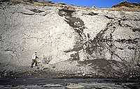
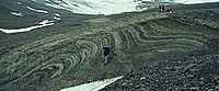
The second image on the right shows Late Weichselian proglacial deformation. A large thrust fault has resulted from glacial movement at Melabakkar, Iceland.
Blind thrust faults
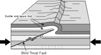
Def. a "thrust fault that does not rupture all the way up to the surface so there is no evidence of it on the ground"[6] is called a blind thrust fault.
"It is "buried" under the uppermost layers of rock in the crust."[6]
Locked faults
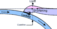
Def. "a fault that is not slipping because frictional resistance on the fault is greater than the shear stress across the fault"[7] is called a locked fault.
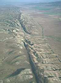
Transform faults
Def. "a special variety of strike-slip fault that accommodates relative horizontal slip between other tectonic elements, such as oceanic crustal plates"[8] is called a transform fault.
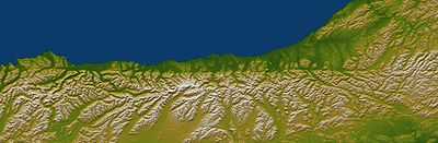
"The Alpine fault runs parallel to, and just inland of, much of the west coast of New Zealand's South Island. This view was created from the near-global digital elevation model produced by the Shuttle Radar Topography Mission (SRTM) and is almost 500 kilometers (just over 300 miles) wide. Northwest is toward the top. The fault is extremely distinct in the topographic pattern, nearly slicing this scene in half lengthwise."[9]
"In a regional context, the Alpine fault is part of a system of faults that connects a west dipping subduction zone to the northeast with an east dipping subduction zone to the southwest, both of which occur along the juncture of the Indo-Australian and Pacific tectonic plates. Thus, the fault itself constitutes the major surface manifestation of the plate boundary here. Offsets of streams and ridges evident in the field, and in this view of SRTM data, indicate right-lateral fault motion. But convergence also occurs across the fault, and this causes the continued uplift of the Southern Alps, New Zealand's largest mountain range, along the southeast side of the fault."[9]
"Two visualization methods were combined to produce this image: shading and color coding of topographic height. The shade image was derived by computing topographic slope in the northwest-southeast (image top to bottom) direction, so that northwest slopes appear bright and southeast slopes appear dark. Color coding is directly related to topographic height, with green at the lower elevations, rising through yellow and tan, to white at the highest elevations."[9]
"Elevation data used in this image were acquired by the Shuttle Radar Topography Mission aboard the Space Shuttle Endeavour, launched on Feb. 11, 2000. SRTM used the same radar instrument that comprised the Spaceborne Imaging Radar-C/X-Band Synthetic Aperture Radar (SIR-C/X-SAR) that flew twice on the Space Shuttle Endeavour in 1994. SRTM was designed to collect 3-D measurements of the Earth's surface. To collect the 3-D data, engineers added a 60-meter (approximately 200-foot) mast, installed additional C-band and X-band antennas, and improved tracking and navigation devices."[9]
The Alpine fault is "495 kilometers (307 miles) by 162 kilometers (100 miles). Location: 43.2 degrees South latitude, 170.5 degrees East longitude. Orientation: Northwest toward the top".[9]
Strike-slip faults
Def. a "fault where two blocks move horizontally in opposite directions along the fault line"[10] is called a strike-slip fault.
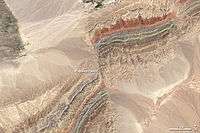
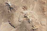
The Piqiang Fault (China) is "a northwest trending strike-slip fault that runs roughly perpendicular to the thrust faults for more than 70 kilometers (40 miles). The colored sedimentary rock layers are offset by about 3 kilometers (2 miles) in this area."[11]
"The reddish, greenish and brownish bands are continental Devonian sandstones, Silurian deeper marine sediments and Cambro-Ordovician limestones, respectively. They form one of several parallel ridges (up to 1200 m high) which all are composed of the same stack of rocks and belong to the Keping Shan thrust belt immediately south of the Southern Tien Shan Mountains."[12]
Dextral faults
Def. "a strike-slip fault that shows right lateral movement [movement of the right-hand block toward the observer standing across the fault plane]"[13] is called a dextral fault.
The strike-slip fault in the image on the right is a dextral fault.
Sinistral faults
Def. "a strike-slip fault that shows left lateral movement [movement of the left-hand block toward the observer standing across the fault plane]"[14] is called a sinistral fault.
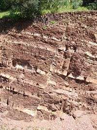
Alternating layers of mudstone and sandstone of the Sidi Bettache Basin of Carboniferous age, cut by a normal fault in Seppap Gorge near Sidi Bettache, Morocco, shown in the image on the right. The outcrop is about 5 metres high.
Surface faults
On the right is an example of a surface fault. Here, the surface above the Hector Mine ruptured after 1999 earthquake in southern California.
Deformed strata
In the image on the right are glaciotectonically "rolled up" soils from the Brúarjökull 1890 end moraine.
The second image on the right shows additional glaciotectonic deformations from the Brúarjökull 1890 end moraine.
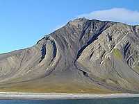
On the left are heavily deformed marine sediments from the Svalbard Kongsoya near Bogen.
The second image on the left shows folded strata dated to the Carboniferous and Permian in Ingeborgfjellet, Van Mienfjorden, Spitsbergen.
Volcanic arcs
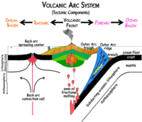
Def. a "chain of volcanoes that sometimes forms on the land when an oceanic plate collides with a continental plate and then slides down underneath it (subduction)"[15] is called a volcanic arc.
Accretionary wedges
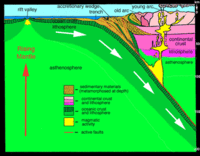
Def. sediments, "the top layer of material on a tectonic plate, that accumulate and deform where oceanic and continental plates collide"[16] are called an accretionary wedge.
"These sediments are scraped off the top of the downgoing oceanic crustal plate and are appended to the edge of the continental plate."[16]
Def. an "accumulation of surface sediment formed between a subducting oceanic crustal plate and a continental tectonic plate, as it is scraped from off the top of the oceanic crustal plate"[17] is called an accretionary wedge.
Folded strata
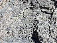
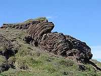
On the right are extensively folded strata from the Kringilsa section in the forefield of Brúarjökull. These folded strata were produced by a glacial surge.
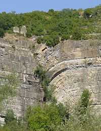
Abrasion platforms

Def. a "sloping or nearly flat bedrock surface extending out from the foot of a marine cliff under shallow water of a breaker (wave) zone, that was created by marine abrasion"[18] is called an abrasion platform.
The rock surface in the image on the right at the foot of the Heads of Ayr cliffs is the result of wave abrasion on the headland.
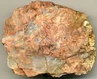
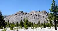
Abyssoliths
Def. a "mass of igneous rock deep in the crust with no known bottom; a large batholith"[19] is called an abyssolith.
"According to systematic deduction from a host of facts the feeders of volcanoes appear to be abyssoliths, molten masses injected upward into the Earth's crust from a vitreous, gas-charged substratum of basalt."[20]
The Sierra Nevada Batholith of which the image on the right is a part has no known bottom.
Allochthons
Def. a "geological formation not formed in the region where found and moved to its present location by tectonic forces"[21] is called an allochthon.
Anticlines
Def. a "fold with strata sloping downwards on each side"[22] is called an anticline.
Anticlinoriums
Def. a "series of parallel anticlinal folds on a regional-scale anticline"[23] is called an anticlinorium.
Aulacogens
Def. a "tectonic trough on a craton that is formed as the failed arm of a triple-rift junction"[24] is called an aulacogen.
Autochthons
Def. a rock formation native to the place where found is called an autochthon.
Autogeosynclines
Def. a "parageosyncline that subsides as an elliptical basin or trough nearly without associated highlands"[25] is called an autogeosyncline.
Backarcs
Def. the "landward region of a volcanic chain, opposite the subduction zone"[26] is called a backarc.
Batholiths
Def. a "large irregular mass of intrusive igneous rock that has melted or forced itself into surrounding strata"[27] is called a batholith.
Diapirs
Def. an "intrusion of a ductile rock into an overburden"[28] is called a diapir.
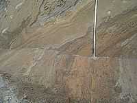
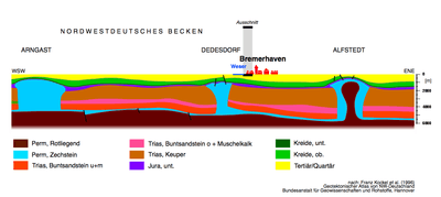
The geological cross section through the Northwestern Basin of Germany (Ostfriesland-Nordheide) above shows the record and deposits since the Permian (about 250 Ma). Salt domes of the Zechstein have penetrated the overburden layers and intruded close to the surface.
Dikes
Def. a "body of once molten igneous rock that was injected into older rocks in a manner that crosses bedding planes"[29] is called a dike.
Diatremes
Def. a "cone-shaped volcanic vent produced by the explosion of gas-filled magma"[30] is called a diatreme.
Eugeosynclines
Def. a "narrow rapidly subsiding geosyncline usually with volcanic materials mingled with clastic sediments"[31] is called a eugeosyncline.
Geanticlines
Def. a "large-scale anticline; a large upward lift in the earth's surface"[32] is called a geanticline.
Geologic joints
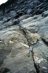
Def. a "fracture in rock in which (unlike a fault) the strata do not move relative to each other"[33] is called a geologic joint.
Geosynclines
Def. a "large, linear depression in the Earth's crust in which sediment accumulates"[34] is called a geosyncline.
Grabens
Def. an "elongated block of the Earth's crust that has dropped relative to the surrounding blocks"[35] is called a graben.
Horsts
Def. "an area of the earth's surface which is raised relative to surrounding land"[36] is called a horst.
Hydrolaccoliths
Def. a "frost mound that has a core of ice and resembles a laccolith in cross-section"[37] is called a hydrolaccolith.
Intrusions
Def. magma "forced into other rock formations; the rock formed when such magma solidifies"[38] is called an intrusion.
Def. "a large body of igneous rock within which distinct stratification continues over many miles"[39] is called a layered intrusion.
Def. the "metamorphism of plutonic rock into magma in the lower levels of the crust"[40] is called anatexis.
Def. an "intrusion of the continental crust subject to anatexis"[41] is called a leucogranite.
Isoclines
Def. a "tightly folded syncline or anticline in which the two sides are almost parallel"[42] is called an isocline.
Laccoliths
Def. "a mass of igneous or volcanic rock found within strata which forces the overlaying strata upwards and forms domes"[43] is called a laccolith.
Lava domes
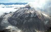

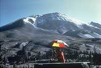
Def. a "roughly circular mound-shaped bulge that builds up from the slow eruption of viscous felsic lava from a volcano"[44] is called a lava dome.
"Lava domes are rarely seen in shield volcanos, but are common in stratovolcanos because the latter have more silicic magmas."[44]
"Mount St. Helens has been building a new lava dome since the May, 1980 eruption."[44]
"Streams of molten rock that ooze from gaps or vents in the Earth’s surface are called lava flows. Though generally slow-moving, these rivers of rock pose a hazard to everything in their paths. They can bury or burn homes and roads, ruin farmland for generations, and transform glaciers into muddy landslides (lahars)."[45]
"Lava flows can take many shapes and move at very different rates depending on the viscosity of the magma, the slope of the land, and the rate of an eruption. Some of the speediest flows travel 60 kilometers (40 miles) per hour; the slowest creep along at less than 1 kilometer (0.6 miles) per hour. They can sometimes even flow for more than a year after an eruption has ended."[45]
"Viscous (or sticky), non-explosive flows produce distinctive landforms known as lava domes. These circular mounds form as lava slowly oozes from a vent and piles up on itself over time. Lava domes tend to have steep, cliff-like fronts at their leading edge and wrinkle-like pressure ridges on their surfaces."[45]
"The Chao dacite is a type of lava dome known as a coulée. These elongated flow structures form when highly-viscous lavas flow onto steep surfaces. On May 14, 2013, the Operational Land Imager (OLI) on NASA’s Landsat 8 satellite acquired the image above, which highlights some of the distinctive features of a coulée."[45]
"The Chao dacite sits between two volcanoes in northern Chile: the older and partially-eroded Cerro del Leon and the younger Paniri. The dome itself is a giant tongue of rock that extends southwest from the vent. Curved pressure ridges known as ogives dominate the surface of the 14 kilometer (9 mile) dome."[45]
"Volcanologists think the Chao dacite dome formed over a period of about 100 to 150 years. A pyroclastic flow during the Chao I phase left light-brown deposits of tephra and pumice at the leading edge of the flow. Pyroclastic flows are avalanche-like events that bring mixtures of hot gas and semi-sold rocks surging down the flanks of volcanoes at speeds as fast as 100 kilometers (60 miles) per hour."[45]
"This period was followed by the Chao II phase, when 22.5 cubic kilometers (5.4 cubic miles) of lava erupted. This flow has 400-meter tall (1,312 feet) fronts that stand out with their dark shadows on the southwest end. The final, Chao III phase added another 3.5 cubic kilometers (0.8 cubic miles) of denser lava with a lower viscosity. This type of lava is less likely to form pressure ridges, so surfaces in this part of the flow are comparatively smooth."[45]
"It’s not clear why the Chao dacite erupted as a flow and formed a dome rather than erupting explosively. However, some researchers have noted that there are a number of other domes in the area (such as Chillahuita), suggesting that the domes may be the leading edge of a broader magmatic system that erupted along pre-existing faults. Though much larger, a series of lava domes along the eastern side of California’s Sierra Nevada range—the Mono-Inyo chain—offers a possible analog for what might be happening in this part of Chile."[45]
Lopoliths
Def. "a mass of volcanic or igneous rock found within strata which has spilled downward into underlaying strata and forms depressed regions"[46] is called a lopolith.
Miogeoclines
Def. an "area of sedimentation that occurs along the passive margin of a continent"[47] is called a miogeocline.
Orthogeosynclines
Def. a "linear geosynclinal belt lying between continental and oceanic cratons, and having internal volcanic belts (eugeosynclinal) and external nonvolcanic belts (miogeosynclinal)"[48] is called an orthogeosyncline.
Research
Hypothesis:
- All or nearly all folded rocks are produced by glacial surges scraping sediment off bedrock while the sediment is still water soaked.
Control groups

The findings demonstrate a statistically systematic change from the status quo or the control group.
“In the design of experiments, treatments [or special properties or characteristics] are applied to [or observed in] experimental units in the treatment group(s).[49] In comparative experiments, members of the complementary group, the control group, receive either no treatment or a standard treatment.[50]"[51]
Proof of concept
Def. a “short and/or incomplete realization of a certain method or idea to demonstrate its feasibility"[52] is called a proof of concept.
Def. evidence that demonstrates that a concept is possible is called proof of concept.
The proof-of-concept structure consists of
- background,
- procedures,
- findings, and
- interpretation.[53]
See also
References
- ↑ Robert J. Twiss (12 April 1992). Structural geology. Macmillan. pp. 532. ISBN 0716722526. http://books.google.com/books?hl=en&lr=lang_en&id=14fn03iJ2r8C&oi=fnd&pg=PR9&ots=Ji9tweQzRK&sig=vOzRLa0ZfHg71w92vWp5UGjkV5o. Retrieved 2014-11-25.
- ↑ "fault, In: Wiktionary". San Francisco, California: Wikimedia Foundation, Inc. 9 November 2014. Retrieved 2014-11-26.
- ↑ Ashley Dace (2011). "ST0343 : The Blue Anchor Fault". United Kingdom: Geograph.org. Retrieved 2014-11-29.
- 1 2 Kerry Sieh (July 18, 2012). "Earthquake Glossary - active fault". USGS. Retrieved 2014-12-01.
- ↑ Kurt Kjær and Ólafur Ingólfsson (2005). "The Brúarjökull Project: Sedimentary environments of a surging glacier". Iceland: Landsvirkjun. Retrieved 2014-11-25.
- 1 2 Stephen Nelson (July 24, 2012). "Earthquake Glossary - blind thrust fault". Reston, Virginia USA: USGS. Retrieved 2014-12-02.
- ↑ Geological Survey of Canada (July 24, 2012). "Earthquake Glossary - locked fault". Reston, Virginia USA: USGS. Retrieved 2014-12-02.
- ↑ EGtransform (July 18, 2012). "Earthquake Glossary - transform fault". Reston, Virginia USA: USGS. Retrieved 2014-12-02.
- 1 2 3 4 5 NASA/JPL/NGA (06 January 2005). "PIA06661: Alpine Fault, New Zealand, SRTM Shaded Relief and Colored Height". Pasadena, California USA: NASA/JPL/NGA. Retrieved 2014-12-02.
- ↑ "strike-slip fault, In: Wiktionary". San Francisco, California: Wikimedia Foundation, Inc. 19 June 2013. Retrieved 2015-02-10.
- ↑ Adam Voiland (16 January 2014). "Faults in Xinjiang". Washington, DC USA: NASA. Retrieved 2016-03-08.
- ↑ Bramfab (30 July 2013). "File:Piqiang Fault, China detail.jpg, In: Wikimedia Commons". San Francisco, California: Wikimedia Foundation, Inc. Retrieved 2016-03-08.
- ↑ "dextral fault, In: Wiktionary". San Francisco, California: Wikimedia Foundation, Inc. 19 June 2013. Retrieved 2015-02-10.
- ↑ "sinistral fault, In: Wiktionary". San Francisco, California: Wikimedia Foundation, Inc. 19 June 2013. Retrieved 2015-02-10.
- ↑ Lynn Fichter (July 24, 2012). "Earthquake Glossary - arc". Reston, Virginia USA: USGS. Retrieved 2014-12-02.
- 1 2 USGS (July 24, 2012). "Earthquake Glossary - accretionary wedge". Reston, Virginia USA: USGS. Retrieved 2014-12-02.
- ↑ "accretionary wedge, In: Wiktionary". San Francisco, California: Wikimedia Foundation, Inc. 16 June 2013. Retrieved 2015-02-09.
- ↑ "abrasion platform, In: Wiktionary". San Francisco, California: Wikimedia Foundation, Inc. 12 January 2015. Retrieved 2015-02-09.
- ↑ "abyssolith, In: Wiktionary". San Francisco, California: Wikimedia Foundation, Inc. 23 May 2014. Retrieved 2015-02-09.
- ↑ Reginald A. Daly (August 1938). "The roots of volcanoes". Eos, Transactions American Geophysical Union 19 (1): 35-9. doi:10.1029/TR019i001p00035. http://onlinelibrary.wiley.com/doi/10.1029/TR019i001p00035/full. Retrieved 2016-03-08.
- ↑ "allochthon, In: Wiktionary". San Francisco, California: Wikimedia Foundation, Inc. 25 January 2015. Retrieved 2015-02-09.
- ↑ "anticline, In: Wiktionary". San Francisco, California: Wikimedia Foundation, Inc. 7 June 2014. Retrieved 2015-02-09.
- ↑ "anticlinorium, In: Wiktionary". San Francisco, California: Wikimedia Foundation, Inc. 19 September 2013. Retrieved 2015-02-09.
- ↑ "aulacogen, In: Wiktionary". San Francisco, California: Wikimedia Foundation, Inc. 29 March 2014. Retrieved 2015-02-09.
- ↑ "autogeosyncline, In: Wiktionary". San Francisco, California: Wikimedia Foundation, Inc. 4 January 2015. Retrieved 2015-02-09.
- ↑ "backarc, In: Wiktionary". San Francisco, California: Wikimedia Foundation, Inc. 16 June 2013. Retrieved 2015-02-10.
- ↑ "batholith, In: Wiktionary". San Francisco, California: Wikimedia Foundation, Inc. 15 December 2014. Retrieved 2015-02-09.
- ↑ "diapir, In: Wiktionary". San Francisco, California: Wikimedia Foundation, Inc. 16 December 2014. Retrieved 2015-02-10.
- ↑ "dike, In: Wiktionary". San Francisco, California: Wikimedia Foundation, Inc. 24 August 2014. Retrieved 2015-02-10.
- ↑ "diatreme, In: Wiktionary". San Francisco, California: Wikimedia Foundation, Inc. 19 June 2013. Retrieved 2015-02-10.
- ↑ "eugeosyncline, In: Wiktionary". San Francisco, California: Wikimedia Foundation, Inc. 4 January 2015. Retrieved 2015-02-11.
- ↑ "geanticline, In: Wiktionary". San Francisco, California: Wikimedia Foundation, Inc. 16 December 2014. Retrieved 2015-02-11.
- ↑ "geologic joint, In: Wiktionary". San Francisco, California: Wikimedia Foundation, Inc. 20 June 2013. Retrieved 2015-02-11.
- ↑ "geosyncline, In: Wiktionary". San Francisco, California: Wikimedia Foundation, Inc. 16 December 2014. Retrieved 2015-02-11.
- ↑ "graben, In: Wiktionary". San Francisco, California: Wikimedia Foundation, Inc. 2 January 2015. Retrieved 2015-02-11.
- ↑ "horst, In: Wiktionary". San Francisco, California: Wikimedia Foundation, Inc. 24 May 2014. Retrieved 2015-02-11.
- ↑ "hydrolaccolith, In: Wiktionary". San Francisco, California: Wikimedia Foundation, Inc. 27 May 2014. Retrieved 2015-02-11.
- ↑ "intrusion, In: Wiktionary". San Francisco, California: Wikimedia Foundation, Inc. 16 December 2014. Retrieved 2015-02-15.
- ↑ "layered intrusion, In: Wiktionary". San Francisco, California: Wikimedia Foundation, Inc. 19 June 2013. Retrieved 2015-02-18.
- ↑ "anatexis, In: Wiktionary". San Francisco, California: Wikimedia Foundation, Inc. 16 June 2013. Retrieved 2015-02-19.
- ↑ "leucogranite, In: Wiktionary". San Francisco, California: Wikimedia Foundation, Inc. 19 June 2013. Retrieved 2015-02-19.
- ↑ "isocline, In: Wiktionary". San Francisco, California: Wikimedia Foundation, Inc. 16 December 2014. Retrieved 2015-02-16.
- ↑ "laccolith, In: Wiktionary". San Francisco, California: Wikimedia Foundation, Inc. 16 December 2014. Retrieved 2015-02-17.
- 1 2 3 "lava dome, In: Wiktionary". San Francisco, California: Wikimedia Foundation, Inc. 9 October 2013. Retrieved 2015-02-17.
- 1 2 3 4 5 6 7 8 Erik Klemetti and Adam Voiland (21 November 2013). "The Shapes that Lavas Take, Part 1". Washington, DC USA: NASA. Retrieved 2015-02-18.
- ↑ "lopolith, In: Wiktionary". San Francisco, California: Wikimedia Foundation, Inc. 24 May 2014. Retrieved 2015-02-17.
- ↑ "miogeocline, In: Wiktionary". San Francisco, California: Wikimedia Foundation, Inc. 23 August 2011. Retrieved 2015-02-11.
- ↑ "orthogeosyncline, In: Wiktionary". San Francisco, California: Wikimedia Foundation, Inc. 4 January 2015. Retrieved 2015-02-11.
- ↑ Klaus Hinkelmann, Oscar Kempthorne (2008). Design and Analysis of Experiments, Volume I: Introduction to Experimental Design (2nd ed.). Wiley. ISBN 978-0-471-72756-9. http://books.google.com/?id=T3wWj2kVYZgC&printsec=frontcover.
- ↑ R. A. Bailey (2008). Design of comparative experiments. Cambridge University Press. ISBN 978-0-521-68357-9. http://www.cambridge.org/uk/catalogue/catalogue.asp?isbn=9780521683579.
- ↑ "Treatment and control groups, In: Wikipedia". San Francisco, California: Wikimedia Foundation, Inc. May 18, 2012. Retrieved 2012-05-31.
- ↑ "proof of concept, In: Wiktionary". San Francisco, California: Wikimedia Foundation, Inc. November 10, 2012. Retrieved 2013-01-13.
- ↑ Ginger Lehrman and Ian B Hogue, Sarah Palmer, Cheryl Jennings, Celsa A Spina, Ann Wiegand, Alan L Landay, Robert W Coombs, Douglas D Richman, John W Mellors, John M Coffin, Ronald J Bosch, David M Margolis (August 13, 2005). "Depletion of latent HIV-1 infection in vivo: a proof-of-concept study". Lancet 366 (9485): 549-55. doi:10.1016/S0140-6736(05)67098-5. http://www.ncbi.nlm.nih.gov/pmc/articles/PMC1894952/. Retrieved 2012-05-09.
Further reading
- Robert J. Twiss (12 April 1992). Structural geology. Macmillan. pp. 532. ISBN 0716722526. http://books.google.com/books?hl=en&lr=lang_en&id=14fn03iJ2r8C&oi=fnd&pg=PR9&ots=Ji9tweQzRK&sig=vOzRLa0ZfHg71w92vWp5UGjkV5o. Retrieved 2014-11-25.
External links
- Dictionary of Geology
- Earthquake Glossary
- Geography and geology images of Great Britain and Ireland
- Schlumberger Oilfield Glossary
- Google Map of Geology: Zoom in close on over 80 examples of structural geology terms.
![]() This is a research project at http://en.wikiversity.org
This is a research project at http://en.wikiversity.org