Geochronology/Stratigraphy
< Geochronology.jpg)
Stratigraphy is concerned with the order and relative position of strata and their relationship to the geological time scale.
The image at the right shows rock strata in Cafayate, Argentina, the subject of stratigraphy.
Theoretical stratigraphy
Def. the "study of rock layers and the layering process"[1] is called stratigraphy.
Stratigraphic columns
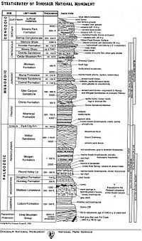
As an example of a stratigraphic column, the image at the right shows one for the Dinosaur National Monument, Utah and Colorado, USA.
Each geographic location on the rocky surface of the Earth has a stratigraphic column. Correlating each stratum that has been shown to be in a geologic time period with others around the world is part of the fun of stratigraphy.
Geography
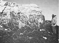
At the right is a small portion of the stratigraphic column between the Hatherton and MacKay glaciers in Antarctica. The top rock layer is a greyish red siltstone. The next downward is a greenish grey siltstone penetrated by sinuous tubes that may be roots or root-like structures. Underlaying this is "a zone of calcareous nodules."[2]
"The Beacon Supergroup (Barrett, 1970) in the Transantarctic Mountains is largely a flat-lying, nonmarine sequence from Devonian or older to Jurassic in age. It consists of the Taylor Group (Devonian or older), a quartzose sandstone sequence, and the Victoria Group (Permian and Triassic), dominantly a coal-bearing sandstone-siltstone sequence (Harrington, 1965)."[2]
"The Taylor Group comprises up to 1,450 m of quartzose sandstone, with smaller conglomerate, arkosic and shaly units [...]. [The] youngest Taylor Group unit [is] the Aztec Siltstone [of which the image at the right exhibits]."[2]
Glacial sediment layers
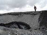

The cross section of a sandur deposit on the right from Iceland shows strata of various sand-like material atop dead ice from a former surge of the glacier Brúarjökull.
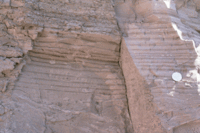
In the second image down on the right: "The pebble beach at Weybourne marks the start of the cliff section of the Norfolk coast that extends in easterly direction. This change in the character of the coastline is due to the properties of the chalk, which is harder to the east. The cliffs resting on this chalk base are composed of layers of glacial sediments of flints and fossils."[3]
Varves
Def. "a pair of sedimentary layers, a couplet, that form in an annual cycle as the result of seasonal weather changes"[4] is called a varve.
"Typically formed in glacial lakes a varve couplet consists of a coarser grained summer layer formed during open-water conditions, and a finer grained winter layer formed from deposition from suspension during a period of winter ice cover. Many varve deposits contain hundreds of couplets."[4]
Lias
Def. a "stratigraphic group from the lower Jurassic period, consisting of thin layers of blue limestone [present in parts of southern England]"[5] is called a lias.
Sediment cores
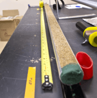
Sediment cores may be obtained "by drilling or jack-hammering a steel rod or shoving a hand auger or hollow "push core" into a beach or marsh or water bottom, and pulling up sediment samples for analysis."[6]
"You can think of a sediment core as being more or less a tape recorder of time. Within that sediment core, we work with proxies, or environmental proxies, and these can be very simple measures of grain size or composition or some organic geochemical property or maybe pollen."[7]
"There are environments that preserve storm records that are buried in the sea bed, so that you can go down through time and actually develop a record of the intensity and frequency of cyclonic storms. That's something that's pretty high up on the radar for coastal inhabitants. Kind of understanding the pattern of these storms through time helps us to understand what might be coming down the pike."[7]
"You take a sediment core through a barrier island and under that is marsh, bay, marsh, mainland. You have maybe an old forest, roots. Looking back in time at that location, hundreds of thousands of years ago, you get this vertical succession of these different layers."[8]
Technology
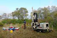
"A VIMS field crew [assembled in the image on the right] collects sediment cores on the landward side of the Plum Island barrier island in May 2014. These cores were collected with a Geoprobe drill rig [shown] and went as much as 60 feet below the surface of the island. Cores were collected in 4 feet sections and brought back to VIMS for processing."[9]
Research Opportunities
Hypothesis:
- To obtain stratigraphic columns in locations where exposures do not occur, corings may provide alternatives.
See Research, Control group, and Proof of concept for more information.
See also
References
- ↑ SemperBlotto (27 August 2014). "stratigraphy, In: Wiktionary". San Francisco, California: Wikimedia Foundation, Inc. Retrieved 2014-09-21.
- 1 2 3 P. J. Barrett, B. P. Kohn, R. A. Askin & J. G. McPherson (1971). "Preliminary report on Beacon Supergroup studies between the Hatherton and Mackay glaciers, Antarctica". New Zealand Journal of Geology and Geophysics 14 (3): 605-14. doi:10.1080/00288306.1971.10421951. http://www.tandfonline.com/doi/pdf/10.1080/00288306.1971.10421951. Retrieved 2014-09-27.
- ↑ Evelyn Simak (16 November 2007). "Layers of glacial sediments resting on chalk base". Photograph. Retrieved 2016-01-24.
- 1 2 Eleyne Phillips (16 December 2004). "Glossary of Glacier Terminology". Reston, Virginia USA: United States Geological Survey. Retrieved 2014-11-09.
- ↑ "lias, In: Wiktionary". San Francisco, California: Wikimedia Foundation, Inc. 29 December 2014. Retrieved 2015-02-19.
- ↑ Tamara Dietrich (1 January 2015). "VIMS geologists use sediment cores as a window to the past". DailyPress. Retrieved 2015-01-12.
- 1 2 Steve Kuehl (1 January 2015). "VIMS geologists use sediment cores as a window to the past". DailyPress. Retrieved 2015-01-12.
- ↑ Christopher Hein (1 January 2015). "VIMS geologists use sediment cores as a window to the past". DailyPress. Retrieved 2015-01-12.
- ↑ Joe Fudge (31 December 2014). "Pictures: VIMS studies sediment core samples". Virginia: DailyPress. Retrieved 2015-01-12.
External links
![]() This is a research project at http://en.wikiversity.org
This is a research project at http://en.wikiversity.org
| |
Development status: this resource is experimental in nature. |
| |
Educational level: this is a research resource. |
| |
Resource type: this resource is an article. |
| |
Resource type: this resource contains a lecture or lecture notes. |
| |
Subject classification: this is a Geology resource. |