Sediments

Sediment is particulate matter that is deposited on the surface of land.
The land can be exposed to outer space, an atmosphere, or under a liquid object.
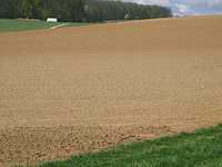
For the projection above: "Sediment thickness values represent an average over each 5-minute grid cell and are located at the center of each cell."[1]
Lithification
Def. the "compaction and cementation of sediment into rock"[2] is called lithification.
Def. a "subdivision of any stratigraphic unit that has characteristic lithologic features"[3] is called a lithofacies.
Def. the "formation of sedimentary rock"[4] is called lithogenesis.
Def. "an element that forms silicates or oxides and is concentrated in the minerals of the Earth's crust"[5] is called a lithophile.
Theoretical sediments
Def. a "collection of small particles, particularly dirt, that precipitates from a river or other body of water"[6] is called a sediment.
Sedimentology
Sedimentology is the science and study of sediments.
With appropriate conditions, sediment is transformed into rock. These are the sedimentary rocks.
Def. a "study of natural sediments and of the processes by which they are formed"[7] is called sedimentology.
Erratics
Def. a "rock moved from one location to another"[8] is called an erratic.
Regoliths
Def. a "layer of loose rock, dust, sand, and soil, resting on the bedrock, that constitutes the surface layer"[9] is called a regolith.
Turbidites
Def. "sea-bottom deposits formed by massive slope failures where rivers have deposited large deltas"[10] are called turbidites.
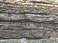
"Turbidites [shown in the image on the right] are sea-bottom deposits formed by massive slope failures where rivers have deposited large deltas. These slopes fail in response to earthquake shaking or excessive sedimentation load. The temporal correlation of turbidite occurrence for some deltas of the Pacific Northwest suggests that these deposits have been formed by earthquakes."[10]
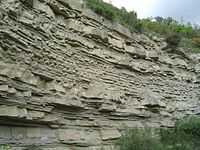
"Turbidites (interbedded with mudstones/siltstones) from the Ross Sandstone Formation Turbidite system of Namurian age in County Clare, Western Ireland. The sandstone beds were formed in a deep basin by turbidites coming from a delta area."[10]
Diamictons
Def. "nonsorted, noncalcareous terrigenous deposits composed of sand and/or larger particles dispersed through a muddy matrix"[11] are called diamictons.
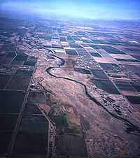
Drifts
Def. a "mass of matter which has been driven or forced onward together in a body, or thrown together in a heap"[12] is called drift.
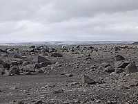
The image on the right shows morainic drift on the surface north of the surge glacier Brúarjökull in Iceland.
Tills
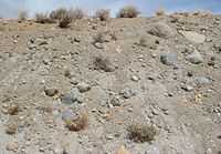
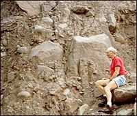
Def. "glacial drift consisting of a mixture of clay, sand, pebbles and boulders"[13] is called till, or glacial till.
The image on the right shows glacial till exposed in a road cut with some plants growing on top.
Alluviums
Def. "soil, clay, silt or gravel deposited by flowing water, as it slows, in a river bed, delta, estuary or flood plain"[14] is called alluvium.
Outwashes
Def. a "sediment (mostly sand and gravel) deposited by water flowing from a melting glacier"[15] is called an outwash.
Lahars
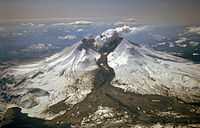
Def. a "volcanic mudflow"[16] is called a lahar.
Part of the Mount St. Helens lahar entered Spirit Lake (lower left corner of the image on the right) but most of the flow went west down the Toutle River, eventually reaching the Cowlitz River, 50 miles (80 kilometers) downstream.
Layered sediments
Def. "a pair of sedimentary layers, a couplet, that form in an annual cycle as the result of seasonal weather changes"[17] is called a varve.
"Typically formed in glacial lakes a varve couplet consists of a coarser grained summer layer formed during open-water conditions, and a finer grained winter layer formed from deposition from suspension during a period of winter ice cover. Many varve deposits contain hundreds of couplets."[17]
"The ruin marble structure of the Cretaceous/Paleogene fine-grained marly limestone from the Outer Flysch Belt of the Western Carpathians has a non-tectonic origin, according to structural and sedimentological evidence. Distinctive offsets of coloured red-brownish ferric oxyhydroxide bands are not due to displacements along rock-cutting fractures, as they superficially appear to be. Evidences for shear movement along these pseudo-faults were not observed. Band offsets result from different velocities of pervasively diffusing fluids, precipitating ferric oxyhydroxides in corridors bounded by sets of mineralised systematic joints. During rock weathering, calcite-filled joints operated as barriers for lateral fluid diffusion, but enabled longitudinal diffusion along healed joints."[18]
Liesegang rings

Def. secondary "rings or bands resulting from rhythmic precipitation in a gel, or within a fluid-saturated rock"[19] are called Liesegang rings.
Loesses
Def. any "sediment, dominated by silt"[20] is called loess.
Def. fine-grained, "silt-size sediment formed by the mechanical erosion of bedrock at the base and sides of a glacier by moving ice"[17] is called rock flour.
"When [rock flour] enters a stream, it turns the stream's color brown, gray, iridescent blue-green, or milky white. [It is also] called Glacier Flour or Glacier Milk."[17]
Soils
Def.
- a "mixture of sand and organic material, used to support plant growth",[21]
- an "unconsolidated mineral or organic material on the immediate surface of the earth that serves as a natural medium for the growth of land plants",[21] and
- an "unconsolidated mineral or organic matter on the surface of the earth that has been subjected to and shows effects of genetic and environmental factors of: climate (including water and temperature effects), and macro- and microorganisms, conditioned by relief, acting on parent material over a period of time"[21]
is called a soil.
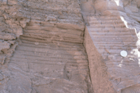
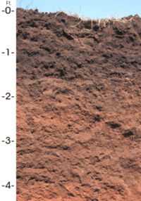
"The Port series [shown in the profile on the right] consists of very deep, well-drained, moderately permeable, nearly level and very gently sloping soils on flood plains that are subject to frequent, occasional, or rare flooding. These soils are in western and central Oklahoma. They are in 33 of the 77 counties and make up about 1 million acres."[22]
"These soils formed in calcareous, loamy alluvium and under native grasses. A high volume of organic matter recycled in a grass ecosystem has resulted in good soil structure and tilth. Most areas of the soils are used as cropland. The main cultivated crops are alfalfa, wheat, grain sorghum, and cotton. Some areas are used as pasture or rangeland."[22]
Intraclasts
Def. a "sediment formed by the redeposition of material erodes from an original deposit"[23] is called an intraclast.
Laterites
Def. a "red hard or gravel-like soil or subsoil [...] that has been leached of soluble minerals leaving insoluble iron and aluminium oxides and hydroxides"[24] is called a laterite.
Fossils
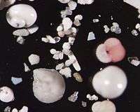
"Microscopic shells in seafloor sediment collected from Blake Ridge. The large, round shell at the top left of the image is a planktonic pteropod about 0.25mm across. The triangular shell immediately underneath is a benthic, or bottom dwelling, foraminifer, Bolivina. All other larger shells, including the pink one (Gloobigerinoides), are planktonic foraminifers. The planktonic shells have fallen from the surface waters to the seafloor."[25]
Sediment cores
Sediment cores may be obtained "by drilling or jack-hammering a steel rod or shoving a hand auger or hollow "push core" into a beach or marsh or water bottom, and pulling up sediment samples for analysis."[26]
"You can think of a sediment core as being more or less a tape recorder of time. Within that sediment core, we work with proxies, or environmental proxies, and these can be very simple measures of grain size or composition or some organic geochemical property or maybe pollen."[27]
"There are environments that preserve storm records that are buried in the sea bed, so that you can go down through time and actually develop a record of the intensity and frequency of cyclonic storms. That's something that's pretty high up on the radar for coastal inhabitants. Kind of understanding the pattern of these storms through time helps us to understand what might be coming down the pike."[27]
"You take a sediment core through a barrier island and under that is marsh, bay, marsh, mainland. You have maybe an old forest, roots. Looking back in time at that location, hundreds of thousands of years ago, you get this vertical succession of these different layers."[28]
Pleistocene
The Pleistocene dates from 2.588 x 10⁶ to 11,700 b2k.
"The presence of tropical plant and animal remains at the polar latitudes indicate that significantly warmer conditions must have existed as compared to today. Conversely, the absence of tree pollen in the tundra probably means that conditions were too cold for trees to grow."[29]
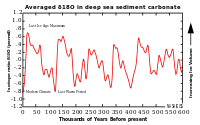
"For more quantitative information you have to look in the oceans, and in particular, at the deep sediments that lie on the bottom of the seas. There, a steady rain of shells from small, surface-dwelling animals falls continually, eventually building up hundreds of meters of sediment. These sediments preserve the shells of these small animals for millions of years, all the way back to the age of the dinosaurs, 65 million years ago."[29]
"The most important of these animals, foraminifera (or forams for short), make their tiny shells from a form of calcium carbonate (CaCO3). This carbonate is found in many common geological features, such as the White Cliffs of Dover, which were once at the bottom of the sea."[29]
"The carbonate, originally dissolved in the oceans, contains oxygen, whose atoms exist in two naturally-occurring stable isotopes, 18O and 16O. The ratio of these two isotopes tells us about past temperatures. When the carbonate solidifies to form a shell, the isotopic ratio in the oxygen (written as δ18O) varies slightly depending on the temperature of the surrounding water. The change is only a tiny 0.2 parts per million decrease for each degree of temperature increase. Nevertheless, this is sufficient for us to be able to estimate the temperature of the water in which the forams lived millions of years ago. From this, we can see that temperatures in the Arctic Ocean were about 10-15°C warmer at the time of the dinosaurs than they are today!"[29]
"The δ18O value in the shells depends critically on what the δ18O value was in the surrounding sea water (H2O), and that can be as variable as the temperature! This variability arises because when water evaporates, the lighter molecules of water (those with 16O atoms as compared to those with 18O) tend to evaporate first. Therefore, water vapor is more depleted (fewer H218O molecules) than the ocean from which it evaporates. Thus, the ocean has more 18O in places where lots of water evaporates (like the sub-tropics) and less where it rains a lot (like the mid-latitudes)."[29]
"Similarly, when water vapor condenses (to make rain for instance), the heavier molecules (H218O) tend to condense and precipitate first. So, as water vapor makes its way poleward from the tropics, it gradually becomes more and more depleted in the heavier isotope. Consequently snow falling in Canada has much less H218O than rain falling in Florida. Changes in climate that alter the global patterns of evaporation or precipitation can therefore cause changes to the background δ18O ratio."[29]
"In addition, the great ice-sheets that once covered North America, consisting of snow falling in what is now Canada, were very depleted in 18O. Now, enough water was held in these ice sheets to reduce the global average sea level by about 120 m. Furthermore, there was also enough depleted water trapped in the ice to increase the average isotopic content of the oceans. And so the first thing we see when we analyze the shells from the bottom of the ocean, is the waxing and waning of the great ice sheets over the last 3 million years [in the figure on the right]. The same pattern over the last 400,000 years can also be seen in the isotopes measured in ice cores drilled from the remaining ice sheets in Greenland and Antarctica."[29]
Technology
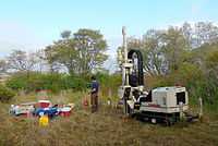
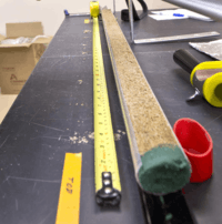
"A VIMS field crew [assembled in the image on the right] collects sediment cores on the landward side of the Plum Island barrier island in May 2014. These cores were collected with a Geoprobe drill rig [shown] and went as much as 60 feet below the surface of the island. Cores were collected in 4 feet sections and brought back to VIMS for processing."[30]
Research
Hypothesis:
- Sediment occurs from the action of rocky, liquid, gaseous, and plasma objects.
Control groups

The findings demonstrate a statistically systematic change from the status quo or the control group.
“In the design of experiments, treatments [or special properties or characteristics] are applied to [or observed in] experimental units in the treatment group(s).[31] In comparative experiments, members of the complementary group, the control group, receive either no treatment or a standard treatment.[32]"[33]
Proof of concept
Def. a “short and/or incomplete realization of a certain method or idea to demonstrate its feasibility"[34] is called a proof of concept.
Def. evidence that demonstrates that a concept is possible is called proof of concept.
The proof-of-concept structure consists of
- background,
- procedures,
- findings, and
- interpretation.[35]
See also
References
- ↑ Barry Eakins (2003). "Total Sediment Thickness of the World's Oceans and Marginal Seas, Version 1". Boulder, CO USA: NOAA National Geophysical Data Center. Retrieved 2016-01-24.
- ↑ "lithification, In: Wiktionary". San Francisco, California: Wikimedia Foundation, Inc. 17 August 2013. Retrieved 2015-02-19.
- ↑ "lithofacies, In: Wiktionary". San Francisco, California: Wikimedia Foundation, Inc. 27 May 2014. Retrieved 2015-02-19.
- ↑ "lithogenesis, In: Wiktionary". San Francisco, California: Wikimedia Foundation, Inc. 26 May 2014. Retrieved 2015-02-19.
- ↑ "lithophile, In: Wiktionary". San Francisco, California: Wikimedia Foundation, Inc. 2 April 2014. Retrieved 2015-02-19.
- ↑ "sediment, In: Wiktionary". San Francisco, California: Wikimedia Foundation, Inc. 29 October 2014. Retrieved 2014-12-05.
- ↑ SemperBlotto (18 August 2006). "sedimentology, In: Wiktionary". San Francisco, California: Wikimedia Foundation, Inc. Retrieved 2014-11-09.
- ↑ "erratic, In: Wiktionary". San Francisco, California: Wikimedia Foundation, Inc. 13 August 2014. Retrieved 2014-12-05.
- ↑ "regolith, In: Wiktionary". San Francisco, California: Wikimedia Foundation, Inc. 25 May 2014. Retrieved 2014-12-05.
- 1 2 3 USGSTurbidites (July 24, 2012). "Earthquake Glossary - turbidites". Menlo Park, California USA: USGS. Retrieved 2014-12-02.
- ↑ L. J. G. Schermerhorn (September 1966). "Terminology of Mixed Coarse-Fine Sediments: NOTES". Journal of Sedimentary Petrology 36 (3): 831-5. http://archives.datapages.com/data/sepm/journals/v33-37/data/036/036003/0831.htm. Retrieved 2014-11-08.
- ↑ "drift, In: Wiktionary". San Francisco, California: Wikimedia Foundation, Inc. 18 October 2014. Retrieved 2014-12-03.
- ↑ "till, In: Wiktionary". San Francisco, California: Wikimedia Foundation, Inc. 17 November 2014. Retrieved 2014-12-04.
- ↑ SemperBlotto (12 August 2005). "alluvium, In: Wiktionary". San Francisco, California: Wikimedia Foundation, Inc. Retrieved 2014-11-10.
- ↑ "outwash, In: Wiktionary". San Francisco, California: Wikimedia Foundation, Inc. 17 April 2014. Retrieved 2014-12-05.
- ↑ "lahar, In: Wiktionary". San Francisco, California: Wikimedia Foundation, Inc. 16 December 2014. Retrieved 2015-02-17.
- 1 2 3 4 Eleyne Phillips (16 December 2004). "Glossary of Glacier Terminology". Reston, Virginia USA: United States Geological Survey. Retrieved 2014-11-09.
- ↑ František Marko, Daniel Pivko and Vratislav Hurai (2003). "Ruin marble: a record of fracture-controlled fluid flow and precipitation". Geological Quarterly 47 (3): 241-52. https://gq.pgi.gov.pl/article/download/7313/5963. Retrieved 2015-02-21.
- ↑ "Liesegang rings, In: Wiktionary". San Francisco, California: Wikimedia Foundation, Inc. 19 June 2013. Retrieved 2015-02-21.
- ↑ SemperBlotto (31 March 2006). "loess, In: Wiktionary". San Francisco, California: Wikimedia Foundation, Inc. Retrieved 2014-11-10.
- 1 2 3 "soil, In: Wiktionary". San Francisco, California: Wikimedia Foundation, Inc. 25 November 2014. Retrieved 2014-12-05.
- 1 2 Natural Resources Conservation Service (05 December 2014). "Port -- Oklahoma State Soil". Washington, DC USA: U. S. Department of Agriculture. Retrieved 2014-12-05.
- ↑ "intraclast, In: Wiktionary". San Francisco, California: Wikimedia Foundation, Inc. 21 June 2013. Retrieved 2015-02-15.
- ↑ "laterite, In: Wiktionary". San Francisco, California: Wikimedia Foundation, Inc. 24 May 2014. Retrieved 2014-12-05.
- ↑ Nathalie Valette-Silver (27 September 2001). "Microscopic shells in sea floor sediment". NOAA/OER. Retrieved 2016-01-24.
- ↑ Tamara Dietrich (1 January 2015). "VIMS geologists use sediment cores as a window to the past". DailyPress. Retrieved 2015-01-12.
- 1 2 Steve Kuehl (1 January 2015). "VIMS geologists use sediment cores as a window to the past". DailyPress. Retrieved 2015-01-12.
- ↑ Christopher Hein (1 January 2015). "VIMS geologists use sediment cores as a window to the past". DailyPress. Retrieved 2015-01-12.
- 1 2 3 4 5 6 7 Gavin Schmidt (January 1999). "Cold Climates, Warm Climates: How Can We Tell Past Temperatures?". Washington, DC USA: NASA. Retrieved 2016-01-24.
- ↑ Joe Fudge (31 December 2014). "Pictures: VIMS studies sediment core samples". Virginia: DailyPress. Retrieved 2015-01-12.
- ↑ Klaus Hinkelmann, Oscar Kempthorne (2008). Design and Analysis of Experiments, Volume I: Introduction to Experimental Design (2nd ed.). Wiley. ISBN 978-0-471-72756-9. http://books.google.com/?id=T3wWj2kVYZgC&printsec=frontcover.
- ↑ R. A. Bailey (2008). Design of comparative experiments. Cambridge University Press. ISBN 978-0-521-68357-9. http://www.cambridge.org/uk/catalogue/catalogue.asp?isbn=9780521683579.
- ↑ "Treatment and control groups, In: Wikipedia". San Francisco, California: Wikimedia Foundation, Inc. May 18, 2012. Retrieved 2012-05-31.
- ↑ "proof of concept, In: Wiktionary". San Francisco, California: Wikimedia Foundation, Inc. November 10, 2012. Retrieved 2013-01-13.
- ↑ Ginger Lehrman and Ian B Hogue, Sarah Palmer, Cheryl Jennings, Celsa A Spina, Ann Wiegand, Alan L Landay, Robert W Coombs, Douglas D Richman, John W Mellors, John M Coffin, Ronald J Bosch, David M Margolis (August 13, 2005). "Depletion of latent HIV-1 infection in vivo: a proof-of-concept study". Lancet 366 (9485): 549-55. doi:10.1016/S0140-6736(05)67098-5. http://www.ncbi.nlm.nih.gov/pmc/articles/PMC1894952/. Retrieved 2012-05-09.
External links
![]() This is a research project at http://en.wikiversity.org
This is a research project at http://en.wikiversity.org
| |
Development status: this resource is experimental in nature. |
| |
Educational level: this is a research resource. |
| |
Resource type: this resource is an article. |
| |
Resource type: this resource contains a lecture or lecture notes. |
| |
Subject classification: this is a Geology resource. |