Hydromorphology
As geomorphology is the study of landforms, hydromorphology is the study of water forms. Water as with any fluid under the influence of forces like gravity takes on the shape of its container.
But, unlike landforms which show their shapes in the atmosphere subject to the reflection of sunlight, the underwater shape of the water form usually cannot be seen.
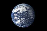
The image on the right is a detailed, photo-like view of Earth based largely on observations from the Moderate Resolution Imaging Spectroradiometer (MODIS) on NASA’s Terra satellite.
Oceans
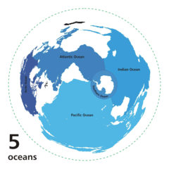
Def. On Earth one "of the five large bodies of water separating the continents"[1] is called an ocean.
Pacific ocean
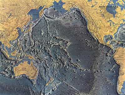
The map above shows the geomorphology of the bottom of the Pacific Ocean.
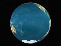
At the top of this resource is a satellite view of the Pacific Ocean with clouds. On the left is a globe view of the Pacific Ocean without clouds. The Pacific Ocean occupies nearly a complete hemisphere of the Earth.
Atlantic ocean
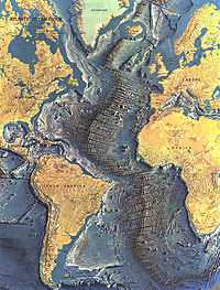
The geomorphology of the bottom of the Atlantic Ocean is shown on the right.
Indian ocean
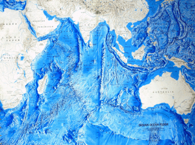
The image on the right shows a topographic map of the land at and above the Indian ocean level.
The bathymetric portion suggests some of the bottom features that provide the lower form of the ocean.
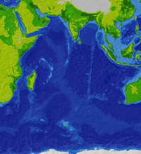
The image above is a more detailed map of the geomorphology of the bottom.
Southern ocean
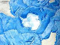
The geomorphology that composes the bottom form of the Southern Ocean is shown on the left.
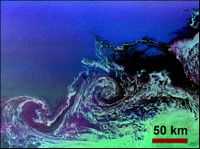
"The [image on the right] shows two large ocean circulation features, called eddies, at the northernmost edge of the sea ice pack in the Weddell Sea, off Antarctica. The eddy processes in this region play an important role in the circulation of the global ocean and the transportation of heat toward the pole. The ... image is the first wide-swath, multi-frequency, multi-polarization radar image ever processed. To date, no other spaceborne radar sensors have obtained swaths exceeding 100 kilometers (62 miles) in width."[2]
"The image is oriented approximately east-west, with a center location of around 56.6 degrees south latitude and 6.5 degrees west longitude. Image dimensions are 240 km by 350 km (149 miles by 218 miles)."[2]
"The ocean eddies have a clockwise (or cyclonic) rotation and are roughly 40 km to 60 km (25 miles to 37 miles) in diameter. The dark areas are new ice and the lighter green areas are small sea-ice floes that are swept along by surface currents; both of these areas are shown within the eddies and to the south of the eddies. First year seasonal ice, typically 0.5 meter to 0.8 meter (1.5 feet to 2.5 feet) thick, is shown in the darker green area in the lower right corner. The open ocean to the north is uniformly bright and appears blue, due to high winds making the surface rough. The colors in both images were obtained using the following radar channels: red is C-band vertically transmitted and vertically received; green is L-band horizontally transmitted and vertically received; and blue is L-band vertically transmitted and vertically received."[2]
Arctic ocean
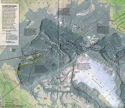
The bottom features of the Arctic Ocean are displayed on the map above.
Sea level
“Mean sea level (MSL) is a measure of the average height of the ocean's surface (such as the halfway point between the mean high tide and the mean low tide); used as a standard in reckoning land elevation.[3] MSL also plays an extremely important role in aviation, where standard sea level pressure is used as the measurement datum of altitude at flight levels.”[4]
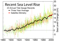
The upper figure at right shows "the change in annually averaged sea level at 23 geologically stable tide gauge sites with long-term records as selected by Douglas (1997). The thick dark line is a three-year moving average of the instrumental records. This data indicates a sea level rise of ~27.5 cm from 1800-2000. Because of the limited geographic coverage of these records, it is not obvious whether the apparent decadal fluctuations represent true variations in global sea level or merely variations across regions that are not resolved."[5]
"For comparison, the recent annually averaged satellite altimetry data [1] from TOPEX/Poseidon are shown in red. These data indicate a somewhat higher rate of increase than tide gauge data, however the source of this discrepancy is not obvious. It may represent systematic error in the satellite record and/or incomplete geographic sampling in the tide gauge record. The month to month scatter on the satellite measurements is roughly the thickness of the plotted red curve."[5]
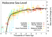
The second figure at the right "shows changes in sea level during the Holocene, the time following the end of the most recent glacial period, based on data from Fleming et al. 1998, Fleming 2000, & Milne et al. 2005. These papers collected data from various reports and adjusted them for subsequent vertical geologic motions, primarily those associated with post-glacial continental and hydroisostatic rebound. The first refers to deformations caused by the weight of continental ice sheets pressing down on the land, the latter refers to uplift in coastal areas resulting from the increased weight of water associated with rising sea levels. It should be noted that because of the latter effect and associated uplift, many islands, especially in the Pacific, exhibited higher local sea levels in the mid Holocene than they do today. Uncertainty about the magnitude of these corrections is the dominant uncertainty in many measurements of Holocene scale sea level change."[6]
"The black curve is based on minimizing the sum of squares error weighted distance between this curve and the plotted data. It was constructed by adjusting a number of specified tie points, typically placed every 1 kyr and forced to go to 0 at the modern day. A small number of extreme outliers were dropped. It should be noted that some authors propose the existence of significant short-term fluctuations in sea level such that the sea level curve might oscillate up and down about this ~1 kyr mean state. Others dispute this and argue that sea level change has been a smooth and gradual process for essentially the entire length of the Holocene. Regardless of such putative fluctuations, evidence such as presented by Morhange et al. (2001) suggests that in the last 10 kyr sea level has never been higher than it is at present."[6]
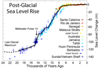
The lower "figure shows sea level rise since the end of the last glacial episode based on data from Fleming et al. 1998, Fleming 2000, & Milne et al. 2005."[7]
"[A]t least one episode of rapid deglaciation, known as meltwater pulse 1A, is agreed upon and indicated on the plot. A variety of other accelerated periods of deglaciation have been proposed (i.e. MWP-1B, 2, 3, 4), but it is unclear if these actually occurred or merely reflect misinterpretation of difficult measurements. No other events are evident in the data presented above."[7]
"The lowest point of sea level during the last glaciation is not well constrained by observations (shown here as a dashed curve), but is generally argued to be approximately 130 +/- 10 m below present sea level and to have occurred at approximately 22 +/- 3 thousand years ago. The time of lowest sea level is more or less equivalent to the last glacial maximum. Prior to this time, ice sheets were still increasing in size so that sea level was decreasing almost continuously over a period of approximately 100,000 years."[7]
Seas
Def. a "large body of salty water"[8] is called a sea.
"In terms of geography, a sea is part of the ocean partially enclosed by land. Seas are smaller than oceans and are usually located where the land and ocean meet. Typically, seas are partially enclosed by land."[9]
Bays

Def. a "body of water ... more or less three-quarters surrounded by land"[10] is called a bay.
Fjords
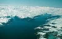
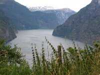
A fjord is usually understood to be a "glacial valley that has been invaded by the sea. A fjord generally has a U-shaped profile with deep water near shore. The two fjords in this picture [on the right] are Barry Arm on the left and College Fiord on the right, in Prince William Sound, Alaska."[11]
Def. a "long, narrow, deep inlet between cliffs"[12] is called a fjord.
Gulfs
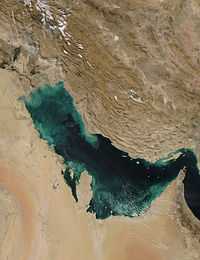
Def. a deep inlet of the sea almost surrounded by land, with a narrow mouth is called a gulf.
Def. a "portion of an ocean or sea extending into the land; a partially landlocked sea"[13] is called a gulf.
Straits
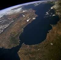
Def. a "narrow channel of water connecting two larger bodies of water"[14] is called a strait.
"The Atlantic Ocean, Straits of Gibraltar, and Alboran Sea (the westernmost portion of the Mediterranean Sea) separate Spain on the [top] from Morocco on the [bottom]. Algeciras Harbor is the prominent notch cut out of the eastern end of the north shore of the Strait; the Rock of Gibraltar is the tiny arrowhead that separates the notch from the Alboran Sea. The Sierra Nevada, farther away down the Spanish coast, lives up to its name in this April scene. The difference in elevation between the Sierra Morena and the Guadalquivir River valley is highlighted nicely by cumulus clouds. Tangier, Morocco can be seen as a light-toned spot on the southern shore of the Strait, near the entrance to the Atlantic Ocean."[15]
Channels
Def.
- a "natural ... deeper course through a reef, bar, bay, or any shallow body of water",[16]
- a "navigable part of a river",[16] or
- a "narrow body of water between two land masses"[16] is called a channel.
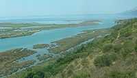
Estuaries
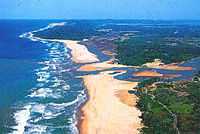
Def. coastal "water body where ocean tides and river water merge"[17] or an "ocean inlet also fed by fresh river water"[17] is called an estuary.
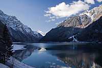
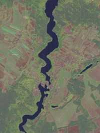
Lakes
.jpg)
Def. a "large, landlocked stretch of water"[18] is called a lake.
Great Lakes
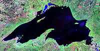
"Of all the world's freshwater lakes, North America's Great Lakes are unique. Their five basins combine to form a single watershed with one common outlet to the ocean. The total volume of the lakes is about 5,475 cubic miles, more than 6,000 trillion gallons."[19]
"The Huron Lobe and the Michigan Lobe are at the same elevation and are connected by the 120-foot-deep Mackinac Strait, also at the same elevation. Lakes are separated from each other by streams and rivers. The Strait of Mackinac is not a river. It is 3.6 to 5 miles wide, wider than most lakes are long. In essence, it is just a narrowing, not a separation of the two lobes of Lake Michigan-Huron."[19]
"The flow between the two lakes can reverse. Because of the large connecting channel, the two can equalize rapidly whenever a water level imbalance occurs. Gauge records for the lakes clearly show them to have identical water level regimes and mean long-term behavior; that is, they are hydrologically considered to be one lake."[19]
"The Great Lakes are Superior, with an area of 31,820 square miles (82,414 km) shared by the United States and Canada; Huron, with an area of 23,010 square miles (59,596 sq. km) shared by the United States and Canada; Michigan, with an area of 22,400 square miles (58,016 sq. km) entirely in the United States; Erie, with an area of 9,930 square miles (25,719 km) shared by the United States and Canada; and Ontario, with an area of 7,520 square miles (19,477 km) shared by the United States and Canada."[19]
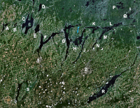
Kettle lakes
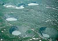
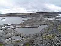
The lakes in the image on the right "are freshly formed in the outwash plain of the retreating Bering Glacier in southern Alaska."[11]
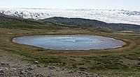
In the image on the left is a kettle lake in the highlands of Isunngua, Greenland.
Dead ice lakes
"Lake sediments constitute the only continuous archives in the area that can register both local and regional environmental changes, including tephra fall-outs. The area is abundant in lakes and the strategy is to core at least three different lakes of varying settings: (i) one should be connected, through influence of glacial melt water, with the present day glacier as well as with the large surge events, which means that it should be a major sedimentation basin within the main extraglacial fluvial system [such lakes as in the image on the right may occur in a dead ice zone from downwasting], (ii) one lake should only be connected to a glacial melt water system during surges, and (iii) one basin should be without direct contact to the glacial system, but register the regional environmental and climate changes, including local and regional tephras."[20]
Thermokarst lakes
Def. "water that forms transition layers at mineral/water and mineral/water/ice interfaces in frozen ground"[21] is called interfacial water.
Def. "water occurring in unfrozen zones (taliks and cryopegs) within permafrost"[21] is called interpermafrost water.
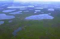
At the right is an "aerial view [of] thermokarst lakes outside the town of Chersky in northeast Siberia [on] August 28, 2007."[22]
Def. "a lake occupying a closed depression formed by settlement of the ground following thawing of ice-rich permafrost or the melting of massive ice"[21] is called a thermokarst lake.
"Paul Lake is located [...] at the border of Wisconsin and the upper peninsula of Michigan, USA [...] The center of the property is positioned at 46°13'N 89°32'E, with an altitude range between 500 and 520 m."[23]
It "lies in [the] Northern Highland Province, which is the southernmost extension of the Canadian Shield. This province is characterized primarily by Pre-Cambrian bedrocks capped by a thin layer of sedimentary rocks left by the Paleozoic seas. On top of this formation are glacial deposits left by the Woodfordian and Valderan substages of the Wisconsinian glaciers. These glacial deposits are young and the drainage system is poorly developed. The surface deposits are characteristic of glacial retreat, consisting of infertile, sandy, pitted glacial out-wash or boulder and clay morainic deposits. As a result of their composition, the soils have a reduced capacity for cation exchange, leaving them very susceptible to acidification. Many of the lakes in this region are kettle lakes, others originate from irregular depressions in the ground moraine or were scoured out of the bedrock as the glaciers passed."[23]
"Paul Lake has a surface area of 1 ha, a mean depth of 6 m, and a maximum depth of 13 m [...]. All the water entering Paul Lake comes from atmospheric deposition and groundwater seepage. Paul Lake generally remains stratified year-long because of a biogenic meromixis [...] and has been classified mesotrophic [...]. The concentration of soluble reactive phosphorus remains low in surface waters year-long, but nutrient regeneration at the oxic/anoxic transition promotes phyto-planktonic blooms just above this interface [...]."[23]
Ribbon lakes
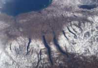
"A late fall snowstorm frosted the hills of the Finger Lakes region of central New York in early December. Shapes of the snow-covered hills are accented by the low Sun angles, and contrast with the darker, finger-shaped lakes filling the region’s valleys. The steep, roughly parallel valleys and hills of the Finger Lakes region were shaped by advancing and retreating ice sheets that were as much as 2 miles deep during the last ice age (2 million years to about 10,000 years ago). River valleys were scoured into deep troughs; many are now filled with lakes. The two largest lakes, Seneca and Cayuga, are so deep that the base of their lakebeds are below sea level."[24]
"The cities of Rochester, Syracuse, and Ithaca are included in this field-of-view, taken from the International Space Station. These three cities enjoy large seasonal snowpacks, thanks to the influence of the Great Lakes producing lake-effect snowstorms. Despite its reputation for long winters, the region is balmy compared with the glacial climate present when the landscape was carved. At the time of the greatest ice extent, yearly average temperatures over northern North America were several degrees lower than today."[24]
Ponds
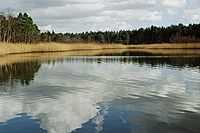
Def. a natural "inland body of standing water [...] that is smaller than a lake"[25] is called a pond.
Intermittent lakes
Def. a "lake that is intermittent; that is, a lake that is dry for part of the year"[26] is called an intermittent lake.
Wetlands
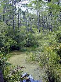
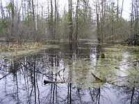
Def. land "that is covered mostly with water, with occasional marshy and soggy areas"[27] is called a wetland.
Def. a "type of wetland that stretches for vast distances"[28] is called a swamp.
Rivers
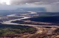

Def. a "large and often winding stream which drains a land mass, carrying water down from higher areas to a lower point, ending at an ocean or in an inland sea"[29] is called a river.
Meanders
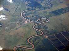
Def. a "winding, crooked, or involved course"[30] or a "tortuous or intricate movement"[30] of water as a stream or river is called a meander.
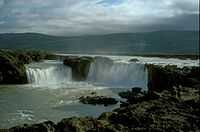
Rapids
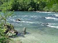
Def. "a rough section of a river or stream which is difficult to navigate due to the swift and turbulent motion of the water"[31] is called a rapid.
On the right are rapids featuring white water before the Rhine Falls.
Waterfalls
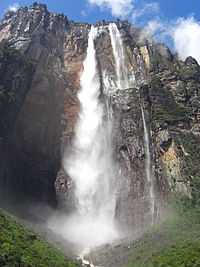
Def. a "flow of water over the edge of a cliff"[32] is called a waterfall.
Angel Falls in the image on the left is the world's tallest at 979 m.
Mouths
Def. the "end of a river out of which water flows into a sea or other large body of water"[33] is called the mouth.
Kolks
Def. "an underwater vortex similar to a whirlwind that is capable of dislodging, picking up, and moving boulders"[34] is called a kolk.
Research
Hypothesis:
- Underneath ice there may be water.
Control groups

The findings demonstrate a statistically systematic change from the status quo or the control group.
“In the design of experiments, treatments [or special properties or characteristics] are applied to [or observed in] experimental units in the treatment group(s).[35] In comparative experiments, members of the complementary group, the control group, receive either no treatment or a standard treatment.[36]"[37]
Proof of concept
Def. a “short and/or incomplete realization of a certain method or idea to demonstrate its feasibility"[38] is called a proof of concept.
Def. evidence that demonstrates that a concept is possible is called proof of concept.
The proof-of-concept structure consists of
- background,
- procedures,
- findings, and
- interpretation.[39]
See also
References
- ↑ "ocean, In: Wiktionary". San Francisco, California: Wikimedia Foundation, Inc. 9 December 2014. Retrieved 2014-12-16.
- 1 2 3 Dornier and Alenia Spazio (31 July 2013). "Weddell Sea/ScanSAR". Pasadena, California USA: NASA/JPL. Retrieved 2014-12-16.
- ↑ "What is "Mean Sea Level"?". Proudman Oceanographic Laboratory.
- ↑ "Sea level, In: Wikipedia". San Francisco, California: Wikimedia Foundation, Inc. September 1, 2012. Retrieved 2012-09-09.
- 1 2 "File:Recent Sea Level Rise.png, In: Wikimedia Commons". San Francisco, California: Wikimedia Foundation, Inc. July 4, 2012. Retrieved 2012-09-09.
- 1 2 "File:Holocene Sea Level.png, In: Wikimedia Commons". San Francisco, California: Wikimedia Foundation, Inc. July 18, 2012. Retrieved 2012-09-09.
- 1 2 3 "File:Post-Glacial Sea Level.png, In: Wikimedia Commons". San Francisco, California: Wikimedia Foundation, Inc. December 26, 2009. Retrieved 2012-09-09.
- ↑ "sea, In: Wiktionary". San Francisco, California: Wikimedia Foundation, Inc. 6 December 2014. Retrieved 2014-12-18.
- ↑ National Ocean Service (March 25, 2014). "What's the difference between an ocean and a sea?". N/MB6, SSMC4, Room 9149, 1305 East-West Hwy, Silver Spring, MD 20910 USA: NOAA's National Ocean Service. Retrieved 2014-12-18.
- ↑ "bay, In: Wiktionary". San Francisco, California: Wikimedia Foundation, Inc. 5 December 2014. Retrieved 2014-12-18.
- 1 2 Hunter (2014). "Glaciers". New York, USA: CUNY. Retrieved 2014-11-24.
- ↑ "fjord, In: Wiktionary". San Francisco, California: Wikimedia Foundation, Inc. 19 October 2014. Retrieved 2014-12-18.
- ↑ "gulf, In: Wiktionary". San Francisco, California: Wikimedia Foundation, Inc. 7 July 2014. Retrieved 2014-12-18.
- ↑ "strait, In: Wiktionary". San Francisco, California: Wikimedia Foundation, Inc. 15 October 2014. Retrieved 2014-12-18.
- ↑ Maura White (14 April 1994). "Morocco and border of spain as seen from STS-59". Houston, Texas USA: Johnson Space Center. Retrieved 2014-12-18.
- 1 2 3 "channel, In: Wiktionary". San Francisco, California: Wikimedia Foundation, Inc. 25 November 2014. Retrieved 2014-12-20.
- 1 2 "estuary, In: Wiktionary". San Francisco, California: Wikimedia Foundation, Inc. 16 December 2014. Retrieved 2014-12-17.
- ↑ "lake, In: Wiktionary". San Francisco, California: Wikimedia Foundation, Inc. 6 December 2014. Retrieved 2014-12-15.
- 1 2 3 4 Pearson Education, Inc. (2014). "Michigan and Huron: One Lake or Two?". InfoPlease.com. Retrieved 2014-12-21.
- ↑ Kurt Kjær and Ólafur Ingólfsson (2004). "The Brúarjökull Project: Sedimentary environments of a surging glacier". Iceland: Brúarjökull Project. Retrieved 2014-11-26.
- 1 2 3 Jane Beitler (19 September 2014). "Cryosphere Glossary". National Snow and Ice Data Center. Retrieved 2014-09-17.
- ↑ Dmitry Solovyov (28 August 2007). "Large increase in leakage of methane gas from the Arctic seabed". The We at WePlanet. Retrieved 2014-09-20.
- 1 2 3 Charles-Philippe Lienemann, Martial Taillepert, Didier Perret, and Jean-François Gaillard (1997). "Association of cobalt and manganese in aquatic systems: Chemical and microscopic evidence". Geochimica et Cosmochimica Acta 61 (7): 1437-46. http://shadow.eas.gatech.edu/~mtaillef/Research/GCA1997.pdf. Retrieved 2014-10-23.
- 1 2 Charles Ichoku (20 December 2004). "New York's Finger Lakes". Washington, DC USA: NASA. Retrieved 2014-12-19.
- ↑ "pond, In: Wiktionary". San Francisco, California: Wikimedia Foundation, Inc. 8 December 2014. Retrieved 2014-12-18.
- ↑ "intermittent lake, In: Wiktionary". San Francisco, California: Wikimedia Foundation, Inc. 21 June 2013. Retrieved 2015-02-15.
- ↑ "wetland, In: Wiktionary". San Francisco, California: Wikimedia Foundation, Inc. 2 December 2014. Retrieved 2014-12-18.
- ↑ "swamp, In: Wiktionary". San Francisco, California: Wikimedia Foundation, Inc. 6 December 2014. Retrieved 2014-12-18.
- ↑ "river, In: Wiktionary". San Francisco, California: Wikimedia Foundation, Inc. 6 December 2014. Retrieved 2014-12-16.
- 1 2 "meander, In: Wiktionary". San Francisco, California: Wikimedia Foundation, Inc. 4 December 2014. Retrieved 2014-12-15.
- ↑ "rapid, In: Wiktionary". San Francisco, California: Wikimedia Foundation, Inc. 4 December 2014. Retrieved 2014-12-16.
- ↑ "waterfall, In: Wiktionary". San Francisco, California: Wikimedia Foundation, Inc. 27 October 2014. Retrieved 2014-12-17.
- ↑ "mouth, In: Wiktionary". San Francisco, California: Wikimedia Foundation, Inc. 6 December 2014. Retrieved 2014-12-16.
- ↑ "kolk, In: Wiktionary". San Francisco, California: Wikimedia Foundation, Inc. 28 March 2014. Retrieved 2015-02-17.
- ↑ Klaus Hinkelmann, Oscar Kempthorne (2008). Design and Analysis of Experiments, Volume I: Introduction to Experimental Design (2nd ed.). Wiley. ISBN 978-0-471-72756-9. http://books.google.com/?id=T3wWj2kVYZgC&printsec=frontcover.
- ↑ R. A. Bailey (2008). Design of comparative experiments. Cambridge University Press. ISBN 978-0-521-68357-9. http://www.cambridge.org/uk/catalogue/catalogue.asp?isbn=9780521683579.
- ↑ "Treatment and control groups, In: Wikipedia". San Francisco, California: Wikimedia Foundation, Inc. May 18, 2012. Retrieved 2012-05-31.
- ↑ "proof of concept, In: Wiktionary". San Francisco, California: Wikimedia Foundation, Inc. November 10, 2012. Retrieved 2013-01-13.
- ↑ Ginger Lehrman and Ian B Hogue, Sarah Palmer, Cheryl Jennings, Celsa A Spina, Ann Wiegand, Alan L Landay, Robert W Coombs, Douglas D Richman, John W Mellors, John M Coffin, Ronald J Bosch, David M Margolis (August 13, 2005). "Depletion of latent HIV-1 infection in vivo: a proof-of-concept study". Lancet 366 (9485): 549-55. doi:10.1016/S0140-6736(05)67098-5. http://www.ncbi.nlm.nih.gov/pmc/articles/PMC1894952/. Retrieved 2012-05-09.
External links
![]() This is a research project at http://en.wikiversity.org
This is a research project at http://en.wikiversity.org
| |
Development status: this resource is experimental in nature. |
| |
Educational level: this is a research resource. |
| |
Resource type: this resource is an article. |
| |
Resource type: this resource contains a lecture or lecture notes. |
| |
Subject classification: this is a Geology resource. |