Geoseismology
The science concerned with the ability of the natural geophysical Earth to either generate or conduct sound and vibration waves is referred to as geoseismology.
Theoretical geoseismology
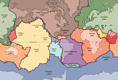
"In geologic terms, a plate is a large, rigid slab of solid rock. The word tectonics comes from the Greek root "to build." Putting these two words together, we get the term plate tectonics, which refers to how the Earth's surface is built of plates. The theory of plate tectonics states that the Earth's outermost layer is fragmented into a dozen or more large and small plates that are moving relative to one another as they ride atop hotter, more mobile material."[1]
Oceans
Sound "waves tend to bend downward as they travel at shallow depths. Conversely, the waves bend upward as they propagate at deeper depths."[2]
Def. "a continuous layer in the deep ocean where sound waves are focused, thus providing a mechanism for a long-range communications system"[2] is called a Sound Fixing and Ranging (SOFAR) channel.
"The depth of this channel varies in different oceans depending on the salinity, temperature, and depth of the water. It may be anywhere from 600 to 1500 meters below the surface, depending on these variables."[2]
"[L]ow-frequency waves are less vulnerable than higher frequencies to scattering and absorption."[2]
An "underwater TNT explosion [was set off] in the Bahamas at a depth of 1500 meters, which was easily detected by receivers 2,000 miles away on the coast of West Africa."[2]
Sound "propagating through the SOFAR channel [may be used] to study underwater earthquakes, volcanoes and whales."[2]
"SOFAR floats [were used] in the 1970s to measure and track oceanic currents. The floats were free- drifting underwater buoys. The floats sent out acoustic pulses, typically at 260 Hz. Moored listening stations at known locations received the sound signals. The position of each float was determined using time of arrival of the signal at three or more hydrophones. SOFAR floats worked at ranges of up to 2500 km, which is about half-way across the Atlantic Ocean."[2]
"The ocean is divided into horizontal layers. The speed of sound is greatly influenced by temperature in the upper layers and by pressure in the deeper layers. The speed of sound decreases as temperature decreases. The speed of sound increases as the pressure (depth) increases. The two effects do not cancel, however. The "channeling" of sound occurs because there is a minimum in the vertical sound speed profile in the ocean caused by the changes in temperature and pressure."[2]
"The principle of sound propagation is that sound rays always bend towards the region of lower sound speed. The refraction of sound waves from higher velocities above and below the sound channel axis thus bends the sound back towards the axis. Sound energy is refracted towards the axis of the sound channel away from the surface and the bottom of the ocean. Furthermore, sound propagates in the SOFAR channel without interacting with either the sea surface or seafloor. These sound waves thus travel with relatively little attenuation beyond that due to geometric spreading."[2]
Sound waves
Def. vibrations that travel through the air or another medium, some of which may be heard by a human or animal's ear is called sound.
These vibrations may be recorded by an accelerometer and discriminated into displacement, velocity, or acceleration as shown in the images on the right.
Body waves
Def. a "seismic wave that travels through the earth's interior"[3] is called a body wave.
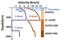
"Primary or P-waves are the fastest seismic waves, and they propagate through solids and liquids."[4]
"Secondary or S-waves travel only through solid materials, at a slower speed than P- waves."[4]
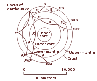
"Cross section of the whole Earth, [in the image on the left shows] the complexity of paths of [seismic] waves. The paths curve because the different rock types found at different depths change the speed at which the waves travel. Solid lines marked P are compressional waves; dashed lines marked S are shear waves. S waves do not travel through the core but may be converted to compressional waves (marked K) on entering the core (PKP, SKS). Waves may be reflected at the surface (PP, PPP, SS)."[5]
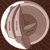
Cores
"The core was the first internal structural element to be identified. It was discovered in 1906 by R.D. Oldham, from his study of earthquake records, and it helped to explain Newton's calculation of the Earth's density. The outer core is presumed to be liquid because it does not transmit shear (S) waves and because the velocity of compressional (P) waves that pass through it is sharply reduced. The inner core is considered to be solid because of the behavior of P and S waves passing through it."[5]
"Data from [seismic] waves, rotations and inertia of the whole Earth, magnetic-field dynamo theory, and laboratory experiments on melting and alloying of iron all contribute to the identification of the composition of the inner and outer core. The core is presumed to be composed principally of iron, with about 10 percent alloy of oxygen or sulfur or nickel, or perhaps some combination of these three elements."[5]
The "Earth’s inner core has an inner core of its own [...] The inner core, once thought to be a solid ball of iron, has some complex structural properties. [It has] a distinct inner-inner core, about half the diameter of the whole inner core. The iron crystals in the outer layer of the inner core are aligned directionally, north-south. However, in the inner-inner core, the iron crystals point roughly east-west."[6]
Seismic "anisotropy in the innermost inner core that has a fast axis near the equatorial plane through Central America and Southeast Asia, [is] in contrast to the north–south alignment of anisotropy in the outer inner core."[7]
“The fact that we have two regions that are distinctly different may tell us something about how the inner core has been evolving. For example, over the history of the earth, the inner core might have had a very dramatic change in its deformation regime. It might hold the key to how the planet has evolved. We are right in the center—literally, the center of the Earth.”[6]
Mantles
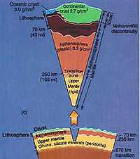
"Between 100 and 200 kilometers below the Earth's surface, the temperature of the rock is near the melting point; molten rock erupted by some volcanoes originates in this region of the mantle. This zone of extremely yielding rock has a slightly lower velocity of [seismic] waves and is presumed to be the layer on which the tectonic plates ride. Below this low-velocity zone is a transition zone in the upper mantle; it contains two discontinuities caused by changes from less dense to more dense minerals. The chemical composition and crystal forms of these minerals have been identified by laboratory experiments at high pressure and temperature. The lower mantle, below the transition zone, is made up of relatively simple iron and magnesium silicate minerals, which change gradually with depth to very dense forms. Going from mantle to core, there is a marked decrease (about 30 percent) in [seismic] wave velocity and a marked increase (about 30 percent) in density."[5]
Primary waves
"P waves [primary waves] are longitudinal [along the axis of propagation] compressional waves. Just like sound waves, they travel through matter causing compression and dilatation [expansion] in an orientation parallel to their direction of propagation. As with sound, the speed at which P waves travel depends upon the properties of the matter through which they propagate. In general, the less dense the matter, the slower the waves."[8]
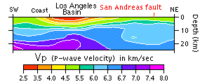
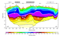
A "velocity model [is] a three-dimensional map [such as in the image on the right] of the variations in P-wave velocity throughout the crust [here] beneath southern California. The velocity profile at [on the right] is a cross-section of such a model. It shows that P waves typically travel through the rocks below southern California at speeds between 5 and 7 kilometers per second, though in sediment-filled basins (like the Los Angeles Basin), they may move as slowly as 3 km/sec. That's still very fast; the speed of sound in air is only 0.3 km/sec!"[8]
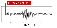
"Because P waves are the first seismic waves to reach any given location after an earthquake occurs, their arrival can be easily identified on a seismogram, like the example [on the right]. This record is read from left to right, as time elapsed during the recording. You can see how the trace (the dark line) starts out, at far left, as a flat line, meaning all was "quiet". The first deflection of the trace from this quiet mode represents the arrival of the P wave."[8]
Secondary waves
"Travelling at a speed typically around 60% that of P waves, S waves always arrive at a location after them -- the "S" stands for secondary. S waves are transverse shear waves. This means that they create a shearing, side-to-side motion transverse (perpendicular) to their direction of propagation (but in any possible orientation, unlike Love waves). Because of this, they can only travel through a substance that has shear strength -- the ability to elastically resist this kind of motion. Liquids and gases have no shear strength, meaning S waves cannot travel through water, air, or even molten rock. It may thus help to think of the "S" as meaning "shear", in addition to "secondary"."[9]
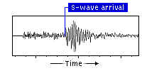
"Identifying the exact time of the initial S-wave arrival [... ] is [usually] accomplished by noting two features of the waveform trace: amplitude and wavelength. S-waves, in addition to being slower than P-waves, also tend to be lower in frequency and longer in wavelength. A sudden increase in wavelength is one way to recognize the arrival of an S-wave on a seismogram. Typically, the more obvious indicator of an S-wave's arrival is a sudden increase in the amplitude of deflection. In cases where the earthquake is large and the source is nearby, however, this method is often not feasible, because the P-wave shaking has not yet decayed to the point where the S-wave arrival "overpowers" it. The image at right, like that [for the primary waves], is a link to an example of an identified S-wave arrival time, on the same seismogram used before."[9]
"When body waves [as opposed to surface waves] encounter a boundary across which their velocity changes -- a contact between two different types of rock, for example, or the ground surface, where rock ends and air begins -- they will reflect and refract, sometimes spawning other body waves, or even surface waves. Large earthquakes can produce body waves detectable all across the globe. Their reflections and refractions as they pass through the planet produce identifiable phases that allow researchers to detect structural and compositional boundaries deep within the Earth. This phenomenon is also responsible for one of the most eerie of earthquake effects: "earth noises"."[9]
Tertiary waves
"Tertiary or T-waves are the slowest of the three types."[4]
"T-waves can be partially converted to other seismic waveforms at a continental or insular shoreline. T-waves can thus be recorded by seismic stations in the vicinity of the coastline."[4]
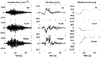
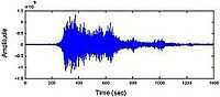
"The T-waves for the Sumatra earthquake were captured by hydrophones located at Diego Garcia, more than 1700 miles (2740 km) from the epicenter. The measured sound pressure time history is shown in [the figure on the right]."[4]
Monochromatic "seismic signals, typically between 3 and 12 Hz, with a lack of overtones [occurred on some seismic recordings from French Polynesia]. The signals were due to oceangoing T- waves, which were particularly active in 1991 and in the early months of 1992. The duration of individual blasts lasted from a few seconds to several minutes. [...] earthquakes and whales [were ruled out] as the source of the T-waves."[4]
The "waves originated at an underwater volcanic ridge in a poorly surveyed region of the South Pacific. New probing showed a flat-topped undersea volcano that rose to within 130 meters of the surface. [...] undersea volcanoes at shallow depths [are] capable of producing T-waves, where the pressure is low enough that bubbles can form in the hot lava."[4]
"Sound waves normally travel at about 1500 meters per second in seawater, but they can slow to one meter per second in a cloud of bubbles generated by the steam from a volcano."[4]
"The cloud becomes sandwiched between the top of the seamount and the ocean surface, forming a resonant cavity. The cavity behaves as an organ pipe, with acoustic waves reflecting back and forth between the boundaries. A standing wave could thus be generated. The standing wave would emit a fundamental tone with overtones, but the gas bubbles would damp out the higher frequency overtones."[4]
Surface waves
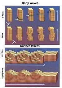
Def. a seismic wave that travels along the earth's surface is called a surface wave.
"Surface waves travel only within the uppermost layers of the Earth -- i.e. along its surface. The two types of surface waves are called Rayleigh waves and Love waves."[10]
"Each of the two surface waves travels literally along the surface of the Earth; the farther below the surface a point is, the smaller the displacement it will experience. Each wave produces a distinct type of motion. Love waves produce transverse motion -- perpendicular to the direction of wave propagation -- in a horizontal orientation only. This kind of horizontal shearing can be devastating to the foundations of buildings."[10]
"Rayleigh waves produce a rolling motion analogous to waves on the surface of a body of water. An object on the surface will experience both an up-and-down motion transverse to, and a back-and-forth motion parallel to, the propagation direction of the Rayleigh wave. The two components combine to produce a rolling, elliptical motion."[10]
Love waves
Def. a "seismic surface shock wave, which is also known as a Q-wave, with a lateral horizontal movement perpendicular to the direction of propagation"[11] is called a Love wave.
Rayleigh waves
Def. an undulating wave that travels over the surface of a solid, with a speed independent of wavelength, the motion of the particles being in ellipses, is called a Rayleigh wave.
Longitudinal waves
Def. a wave vibrating in the direction of propagation is called a longitudinal wave.
Transverse waves
Asthenospheres
Def. "the ductile part of the earth"[12] is called the asthenosphere.
Def. "(hot) electrically conductive, seismically slow material with an anisotropy direction parallel to [absolute plate motion] APM"[13] is called an asthenosphere.
"The asthenosphere is about 180 km thick."[12]
"The hypothesis that the Earth has an asthenosphere can be tested by searching experimentally for a layer with physical properties attributable to its low strength. Since the shear modulus of a material reduces as its melting temperature is approached the asthenosphere should retard the passage of earthquake S-waves, whose velocity is directly proportional to the shear modulus of the material through which it is travelling. The presence of a seismological low velocity layer (LVL) or zone (LVZ) near the top of the mantle thus provides evidence for the asthenosphere. The evidence is particularly convincing since S-waves, which are more sensitive to the prevailing shear modulus than P-waves, are slowed down to a greater extent than the latter. The low velocity zone is much better developed under ocean basins than under continental shield areas where it sometimes barely developed. Hence, oceanic lithosphere is much better defined seismologically than continental lithosphere."[14]
Def. an asthenosphere with a "rapid increase in electrical conductivity, at upper mantle depths"[13] is called an electrical asthenosphere.
The oceanic asthenosphere is apparently at a much lower depth than the asthenosphere is detected at beneath continents.
Conrad discontinuity
"While most impact craters are characterised by negative magnetic anomalies over their central regions, aeromagnetic surveys over the Vredefort meteorite impact crater reveal multiple concentric magnetic patterns with no significant anomaly at its centre. [A] prominent negative magnetic anomaly... extends in a broad semicircular belt about half way into the basement floor of the crater. Magnetic anomalies defined by our data are most often negative and occur over a wide range of wavelengths. The longest wavelength negative anomaly coincides well with aeromagnetic data. [This] feature is centred over the amphibolite to granulite metamorphic facies transition exposed in the basement floor. The transition zone is analogous to the Conrad discontinuity, observed at depths of about 20 km elsewhere in the Kaapvaal craton. Petrographic studies show a marked increase in the intensity of the impact-related thermal and shock metamorphism at this transition, which we explain by the focusing and defocusing of shock waves at a rheologic interface during impact. We therefore suggest that the magnetic signature at this boundary is caused by a combination of both thermal and shock effects related to the impact event. A numerical model of the long wavelength anomaly suggests that it is underlain by a body of coherently magnetised rock whose direction and intensity are similar to those found in pseudotachylites and impact melts that formed during impact. On the other hand, negative anomalies occurring over smaller (100 to 20 m) wavelengths often do not coincide with the surface geology. These features cannot be modeled using the same criteria as that for the long wavelength anomaly."[15]
Lithospheres
Def. "(cold) electrically resistive, seismically fast material with an anisotropy direction often different from present-day absolute plate motion (APM)"[13] is called the lithosphere.
Def. "the depth at which seismic anisotropy direction changes from a lithospheric "fossil" direction to an asthenospheric plate-flow direction parallel to APM"[13] is called the lithosphere-asthenosphere boundary.
"Changes in orientation of anisotropy intensify the P-velocity contrast above and below the LAB, and are reflected in radial and azimuthal anisotropy of surface waves."[13]
Crusts
Good "knowledge of the structure of the crust - P-velocity and Moho depth, and especially thickness and velocity of a sedimentary cover if present beneath a station"[13] is required.
Mohorovicic' discontinuity
Def. "a depth where seismic waves change velocity and there is also a change in chemical composition"[16] is called the Mohorovicic' discontinuity.
"The Moho is the boundary between the crust and the mantle in the earth."[16]
"The boundary is between 25 and 60 km deep beneath the continents and between 5 and 8 km deep beneath the ocean floor."[16]
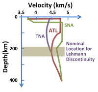
Lehmann discontinuity
Velocity structures
Def. "a generalized regional model of the earth's crust that represents crustal structure using layers having different assumed seismic velocities"[17] is called a velocity structure.
Technology
Def. a seismic "instrument designed specifically to record ... strong ground accelerations"[18] is called an accelerograph.
Def. a "computer software that includes digital mapping with a linked database"[18] is called a Geographic Information System (GIS).
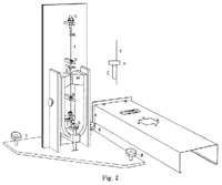
In the torsion seismometer [in the image on the right], motion is generated from the rotation of a small, copper, inertial mass, when the instrument is shaken.
"The Wood-Anderson seismometer was designed to be as sensitive and as nearly frictionless as possible. Damping of the torsional motion was accomplished using magnets (M)."[19]
Def. an " instrument that records the acceleration of the ground during" the [generation or conduction of vibrations][20] is called an accelerograph, or accelerometer.
Def. a "form of microphone that detects and records seismic vibrations"[21] is called a geophone.
Seismographs
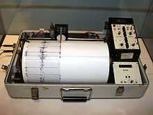
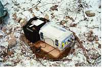
"A seismograph, or seismometer, is an instrument used to detect and record earthquakes. Generally, it consists of a mass attached to a fixed base. During an earthquake, the base moves and the mass does not. The motion of the base with respect to the mass is commonly transformed into an electrical voltage. The electrical voltage is recorded on paper, magnetic tape, or another recording medium. This record is proportional to the motion of the seismometer mass relative to the earth, but it can be mathematically converted to a record of the absolute motion of the ground. Seismograph generally refers to the seismometer and its recording device as a single unit."[22]
Research
Hypothesis:
- Geoseismology is the science of listening to the acoustics of the Earth.
Control groups

The findings demonstrate a statistically systematic change from the status quo or the control group.
“In the design of experiments, treatments [or special properties or characteristics] are applied to [or observed in] experimental units in the treatment group(s).[23] In comparative experiments, members of the complementary group, the control group, receive either no treatment or a standard treatment.[24]"[25]
Proof of concept
Def. a “short and/or incomplete realization of a certain method or idea to demonstrate its feasibility"[26] is called a proof of concept.
Def. evidence that demonstrates that a concept is possible is called proof of concept.
The proof-of-concept structure consists of
- background,
- procedures,
- findings, and
- interpretation.[27]
See also
References
- ↑ JM Watson (07 August 2012). "Historical perspective [This dynamic Earth]". Reston, Virginia USA: USGS. Retrieved 2014-12-01.
- 1 2 3 4 5 6 7 8 9 Tom Irvine (June 2006). "SOFAR Channel". VibrationData.com. Retrieved 2014-11-26.
- ↑ "body wave, In: Wiktionary". San Francisco, California: Wikimedia Foundation, Inc. 5 September 2014. Retrieved 2014-11-30.
- 1 2 3 4 5 6 7 8 9 Tom Irvine (June 2006). "Seismo-acoustic T-waves". VibrationData.com. Retrieved 2014-11-26.
- 1 2 3 4 Eugene C. Robertson (14 January 2011). "The Interior of the Earth". Reston, Virginia USA: USGS. Retrieved 2014-12-01.
- 1 2 Xiaodong Song (March 2015). "Listening for Answers Geologists Rely on Earthquakes to Answer Questions about Earth’s Core". Urbana-Champaign, Illinois USA: University of Illinois. Retrieved 2015-03-20.
- ↑ Tao Wang, Xiaodong Song & Han H. Xia (March 2015). "Equatorial anisotropy in the inner part of Earth’s inner core from autocorrelation of earthquake coda". Nature Geoscience 8 (3): 224-7. doi:10.1038/ngeo2354. http://www.nature.com/ngeo/journal/v8/n3/abs/ngeo2354.html. Retrieved 2015-03-20.
- 1 2 3 SEC3pg11 (2014). "P is for Primary Waves". Southern California Education Council. Retrieved 2014-11-29.
- 1 2 3 s3insetW (30 November 2014). "Secondary Shear Waves". California, USA: Southern California Earthquake Center. Retrieved 2014-11-30.
- 1 2 3 Southern California Earthquake Center (30 November 2014). "P.S. I Rayleigh Love U". California, USA: Southern California Earthquake Center. Retrieved 2014-11-30.
- ↑ "Love wave, In: Wiktionary". San Francisco, California: Wikimedia Foundation, Inc. 19 June 2013. Retrieved 2014-11-30.
- 1 2 U.S. Geological Survey (July 24, 2012). "Earthquake Glossary - asthenosphere". Reston, Virginia, USA: U.S. Geological Survey. Retrieved 2014-12-01.
- 1 2 3 4 5 6 Alan G. Jones, Jaroslava Plomerova, Toivo Korja, Forough Sodoudi, and Wim Spakman (November 2010). "Europe from the bottom up: A statistical examination of the central and northern European lithosphere–asthenosphere boundary from comparing seismological and electromagnetic observations". Lithos 120 (1-2): 14-29. doi:10.1016/j.lithos.2010.07.013. http://www.sciencedirect.com/science/article/pii/S0024493710001891. Retrieved 2014-12-01.
- ↑ The Geological Society (2012). "The Crust and Lithosphere". United Kingdom: The Geological Society. Retrieved 2014-12-01.
- ↑ Manfriedt Muundjua, Rodger J. Hart, Stuart A. Gilder, Laurent Carporzen, Armand Galdeano (September 2007). "Magnetic imaging of the Vredefort impact crater, South Africa". Earth and Planetary Science Letters 261 (3-4): 456-68. doi:10.1016/j.epsl.2007.07.044. http://www.sciencedirect.com/science/article/pii/S0012821X07004505?np=y. Retrieved 2014-12-01.
- 1 2 3 Andrija Mohorovicic' (July 24, 2012). "Moho". Menlo Park, California USA: USGS. Retrieved 2014-12-01.
- ↑ Canales, Detrick, Lin Collins, and Toomey (July 24, 2012). "Earthquake Glossary - velocity structure". Menlo Park, California USA: USGS. Retrieved 2014-12-02.
- 1 2 John E. Ebel, Richard Bedell and Alfredo Urzua (July 1995). "Glossary of Terms: the following is a list of definitions of all technical terms used in this document". Vermont Geological Survey. Retrieved 2014-11-26.
- ↑ Southern California Earthquake Center (01 December 2014). "Wood-Anderson Torsion Seismometer". California, USA: Southern California Earthquake Center. Retrieved 2014-12-01.
- ↑ USGS/Kinemetrics (July 24, 2012). "Earthquake Glossary - accelerograph". Reston, Virginia USA: USGS. Retrieved 2014-12-02.
- ↑ "geophone, In: Wiktionary". San Francisco, California: Wikimedia Foundation, Inc. 4 December 2014. Retrieved 2015-02-11.
- ↑ USGSSeismograph (July 24, 2012). "Earthquake Glossary - seismograph". Reston, Virginia USA: USGS. Retrieved 2014-12-02.
- ↑ Klaus Hinkelmann, Oscar Kempthorne (2008). Design and Analysis of Experiments, Volume I: Introduction to Experimental Design (2nd ed.). Wiley. ISBN 978-0-471-72756-9. http://books.google.com/?id=T3wWj2kVYZgC&printsec=frontcover.
- ↑ R. A. Bailey (2008). Design of comparative experiments. Cambridge University Press. ISBN 978-0-521-68357-9. http://www.cambridge.org/uk/catalogue/catalogue.asp?isbn=9780521683579.
- ↑ "Treatment and control groups, In: Wikipedia". San Francisco, California: Wikimedia Foundation, Inc. May 18, 2012. Retrieved 2012-05-31.
- ↑ "proof of concept, In: Wiktionary". San Francisco, California: Wikimedia Foundation, Inc. November 10, 2012. Retrieved 2013-01-13.
- ↑ Ginger Lehrman and Ian B Hogue, Sarah Palmer, Cheryl Jennings, Celsa A Spina, Ann Wiegand, Alan L Landay, Robert W Coombs, Douglas D Richman, John W Mellors, John M Coffin, Ronald J Bosch, David M Margolis (August 13, 2005). "Depletion of latent HIV-1 infection in vivo: a proof-of-concept study". Lancet 366 (9485): 549-55. doi:10.1016/S0140-6736(05)67098-5. http://www.ncbi.nlm.nih.gov/pmc/articles/PMC1894952/. Retrieved 2012-05-09.
External links
- US Geological Survey Earthquake Glossary
- The Geological Society
- Geologic Province and Thermo-Tectonic Age Maps
![]() This is a research project at http://en.wikiversity.org
This is a research project at http://en.wikiversity.org