Geomorphology
Geomorphology is the science and study of landforms. These are often changed over time. The forces affecting landforms are an aspect of geophysics, geochemistry, ecology, or evolutionary geomorphology.
Rocky-object science
Def. an area of ground that is a part of the Earth's solid surface is called land.
Visuals

Def. a "portion of land or territory which the eye can comprehend in a single view, including all the objects it contains"[1] is called a landscape.
Def. each continuous surface of a landscape that is observable in its entirety and has consistence of form or regular change of form is called a landform.
Theoretical geomorphology
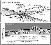
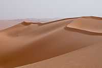
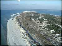
"The size and morphology of coastal dunes is dependent on the complex interaction between controlling winds, sediment supply, and the geomorphology of the nearshore and beach environment."[2]
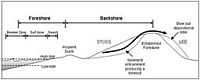
The diagram on the right shows the beach-dune system [with] the nearshore zone back-beach environment and the formation of an incipient foredune and established foredune."[2]
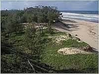
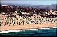
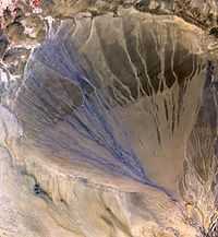
"Secondary dunes are the result of the subsequent modification of the "primary dune" by continued aeolian processes, and are generally located further inland, separated from nearshore processes (Davies 1980). The main secondary dunes include blowouts, parabolic dunes, and transgressive dunefields [image on the left and second right]."[2]
"The wind flow structure in a blowout may be very complex and highly turbulent. Generally, the wind flow is locally accelerated through the blowout and a high speed jet is formed. Thus, wind speeds in the blowout are significantly greater than outside the blowout and this leads to high rates of sand erosion and transport (Carter et al. 1990, Hesp & Hyde 1996, Hesp 1999). Winds remove sand from the deflation basin and the lateral walls and transport it downwind. The erosional walls are then over-steepened and slumping occurs. This causes the erosional walls to retreat, widening the blowout and supplying sediment to the deflation basin, which is then subsequently transported to the depositional lobe. The wind flow is maximised up the axis of the blowout (middle of the deflation basin) towards the depositional lobe. It experiences rapid flow deceleration over the lobe crest, depositing sediment in a radial fashion over the depositional lobe [shown in the images on the right, left and second right]. Deflation basins tend to continue to erode until a base level such as water table level or a more consolidated surface is reached (e.g., old soil profiles, an indurated sediment layer), or a lag surface where coarser materials such as pebbles, shell, or pumice may have been concentrated. Many blowouts become larger over time and may evolve into parabolic dunes [see the two images on the right]."[2]
Def. "the study of the character and origin of landforms"[3] is called geomorphology.
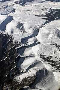
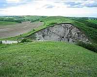
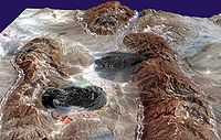
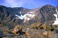
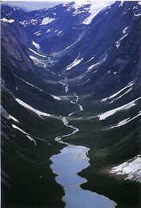
A variety of landforms occasionally occur juxtaposed in a landscape. Theoretical geomorphology is an effort to explain or describe a common cause for these landforms.
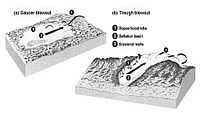
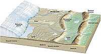
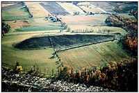
The second image on the left is a model for the landforms that may occur as a glacier retreats or is melted. Landforms to be expected from a retreating glacier include an outwash plain, one or more terminal moraines from repeated retreats or meltings, recessional moraines (an earlier and surged over terminal moraine), kames, an esker, a drumlin field, and a pro-glacial lake in a ground moraine.
When such an assemblage of landforms is discovered, it is reasonable to assert that they were formed by a past glacier that may no longer be present.
Mountain ranges
Def. a "series of adjoining mountains, often in a line"[4] is called a mountain range.
Summit lines
"Coming to the geomorphology of the study area, it must be observed that the [Campano–Lucano Apennines] CLA constitute a markedly asymmetric mountain belt whose summit line is shifted towards the inner belt margin."[5]
Mountains
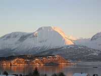
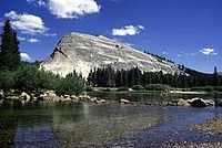
Def. a "large mass of earth and rock, rising above the common level of the earth or adjacent land, usually given by geographers as above 1000 feet in height (or 304.8 metres), though such masses may still be described as hills in comparison with larger mountains"[6] is called a mountain.
Seamounts
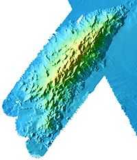
Def. a "mountain that rises from the floor of the ocean and does not breach the water's surface"[7] is called a seamount.
Def. a submarine mountain is called a seamount.
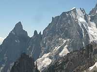
Arêtes
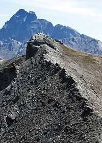
Def. a "very thin ridge of rock"[8] is called an arête.
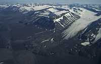
"An earlier [...] glacial episode, herein termed the Altonah Glaciation, is indicated by an extensive lateral moraine beyond the mouth of Yellowstone canyon as well as moraines in Lake Fork and Uinta River canyons. At higher elevations, alpine glacial landforms, including cirques, rock glaciers, arêtes, and hanging valleys are ubiquitous."[9]
"Arêtes and cols are most common in the south-central and southwestern Uinta Mountains, where accumulation areas of glaciers were largest and the development of ice caps that drained into multiple valleys was common. In the south-central Uintas, the most prominent arêtes have more than 450 m of relief and are more than 10 km in length. In the southeastern Uintas, rounded unglaciated divides locally termed “bollies” are more common than narrow arêtes. Examples of these features include broad divides that separate glacial valleys in the headwaters of Dry Fork and Ashley Creeks [...]."[9]
Horns
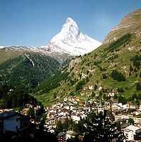
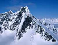
Def. a "pointed, mountain peak, typically pyramidal in shape, bounded by the walls of three or more cirques."[10] is called a horn.
Def. "a peak [that] has four symmetrical faces"[10] is called a Matterhorn.
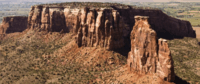
Buttes
Def. "an isolated hill with steep sides and a flat top"[11] is called a butte.
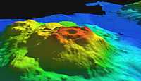
Guyots
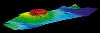
Def. a "flat-topped seamount"[12] is called a guyot.
Hills
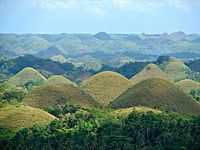
Def. an "elevated location smaller than a mountain"[13] is called a hill.
Def. a naturally raised area of land, not as high or craggy as a mountain is called a hill.
Roche moutonnée
Def. an "elongated, rounded, asymmetrical, bedrock knob produced by glacier erosion"[10] is called a roche moutonnée.
"It has a gentle slope on its up-glacier side and a steep- to vertical-face on the down-glacier side."[10]
"The Lembert Dome in Yosemite National Park [imaged on the left], California, is an exceptionally large roche moutonnée. It clearly demonstrates ice flow from right to left."[14]
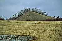
Drumlins
Def. an "elongated hill or ridge of glacial drift"[15] is called a drumlin.
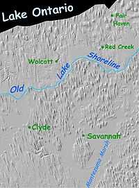
The image on the right is Shaded Relief Imagery from the U.S. Geological Survey to emphasize the relative relief and parallelism of the small hills in Wayne County, New York, USA, south of Lake Ontario.
The image on the left shows one drumlin in the Midwest USA. The ice apparently approached from the larger end and traveled along the length of the drumlin.
Moraines
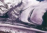
"Lateral and terminal moraines of a valley glacier, Bylot Island, Canada [are shown in the image at the left]. The glacier formed a massive sharp-crested lateral moraine at the maximum of its expansion during the Little Ice Age. The more rounded terminal moraine at the front consists of medial moraines that were created by the junction of tributary glaciers upstream."[16]
Def. "a mound, ridge, or other distinct accumulation of glacial till"[16] is called a moraine.
Def. "a ridge-shaped moraine deposited at the side of a glacier and composed of material eroded from the valley walls by the moving glacier"[16] is called a lateral moraine.
Def. "a ridge-shaped moraine deposited at the [terminus] of a glacier and composed of material eroded from the valley walls by the moving glacier"[16] is called a terminal moraine.
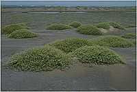
Hummocky terranes
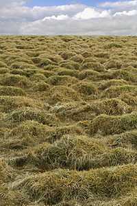
Def. a "ridge or hill of ice in an ice field" or a "small hill; a hillock; a knoll"[17] is called a hummock.
On the right is hummocky ice on the coast of Estonia in the Gulf of Finland.
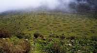
On the left is patterned ground to the west of Mugi hill on Mount Kenya. The hummocks are caused by repeated freezing of the ground in a process known as frost heaving.
Part of the the 1890 Brúarjökull end moraine complex is on the second right. It is also hummocky terrane on a larger scale.
Def. "perennial hummocks formed in either the active layer in permafrost areas, or in the seasonally frozen ground in non-permafrost areas, during freezing of the ground"[16] is called thufur.
"Driftwood sometimes forms the focus for the initial accumulation of dune sand, but vegetation is the most common roughness element that contributes to the formation of incipient dunes [such as the small] hummocks (termed nebkha[in the third image on the right]) formed by sand deposition within discrete plants on the backshore at Dona Juana dunefield, Mexico."[2]
Kames
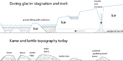
Def. a "round hill or short ridge of sand or gravel deposited by a melting glacier"[18] is called a kame.
Def. "a hill or hummock composed of stratified sand and gravel laid down by glacial meltwater"[19] is called a kame.
"Kames are amongst the most varied landforms resulting from deposition by glacial meltwater. A kame (Scots kaim a hill) may occur as an isolated hill but more generally each kame is one mound in a low-lying terrain of many hummocks, terraces, ridges and hollows. Kames often occur in association with kettle holes in kame and kettle topography. Eskers may also occur between the kames. Meltwater channels may be cut into and between the kames. These associations indicate that kames are formed close to ice margins in situations where there are large volumes of both meltwater and debris."[19]
"The sediments inside kames are often exposed by quarrying. Bedded and sorted sand and gravel predominates but often sharp lateral variations are apparent in the calibre of the material, indicating rapid changes in flow velocity. Small details may reveal much about the events during deposition. The sloping beds of delta foresets indicate sand deposition in a pond or lake. Sands clasts, rounded blocks of now-loose sand, show that beds of saturated sands were frozen prior to transport. Beds of sand and gravel may be displaced by faults or rucked by folds, signs that the sides of the kame may have slumped after deposition or that ice has pushed forward again. Some kames are capped by till, indicating a late readvance of ice or deposition in a pond beneath the ice. Ice wedge casts on the surface of the kame point to the development of permafrost during and after ice retreat."[19]
"Kames form in the chaotic zone of melting ice, water and oozing sediment close to the ice margin. Virtually any hollow within the decaying front may fill with water and receive sediment - crevasses, moulins and larger cavities. As the ice melts, the kame begins to emerge as a hump but its side are saturated and no longer supported by ice and so slumping is possible. Buried blocks of ice melt slowly to leave water-filled kettle holes."[19]
Eskers
"Normally this kind of landform [in the image on the right from Northern Manitoba, Canada] would be wiped out as the ice sheet shifts and the meltwater streams change course. This particular esker must have been laid down just before the ice sheet stopped moving and began to melt for the last time."[20]
Dunes
Def. a "ridge or hill of sand piled up by the wind"[21] is called a dune.
Def. "dunes with a sand supply derived primarily from the beach"[2] are called primary dunes.
Def. dunes "in which vegetation plays a major role (i.e., impedes downwind transport) in the development of the dune"[2] are called impeded primary dunes.
Def. dunes which "develop at the rear of the backshore environments (landward of the active beach) and generally comprise shore-parallel, convex, symmetrical to asymmetrical dune ridges"[2] are called foredunes.
Def. "the initial dunes which accumulate above the high spring tide mark and form due to the presence of some roughness element at the rear of the beach that rapidly reduces wind flow velocities, resulting in sediment accumulation"[2] are called incipient foredunes.
Def. incipient foredunes that survive severe storm events "and grow to become larger"[2] are called established foredunes.
Def. incipient foredunes that survive severe storm events, become "stable as a new incipient foredune develops to seaward"[2] are called relict foredunes.
"If the sediment supply is adequate, a new incipient dune may form seaward of the established foredune, resulting in the established foredune being relatively isolated from the sediment supply. The isolation of the dune, coupled with coastal progradation, can result in the development of successive foredunes that may eventually form a wide foredune plain [image on the left]."[2]
"A modern foredune and relict foredunes [are] forming a foredune plain at Cape San Blas, Florida [in the image on the left]. Note that bars are migrating alongshore, attaching to the beach and providing new sediment to both prograde the beach and build new foredunes."[2]
"Once initiated, the subsequent development of a blowout depends on the size of the initial airflow constriction, the height and width of the dune in which the blowout is developing, the degree and type of vegetation cover, the magnitude of regional winds and the degree of exposure to winds from various directions. The morphology of blowouts is characterised by a deflation (erosional) basin floor or depression, lateral erosional walls, and a downwind depositional lobe [the images in theoretical geomorphology and on the second left]."[2]
"Continued transport of sand through blowouts often results in the development of parabolic dunes. These consist of an actively advancing nose and depositional lobe with two trailing arms that enclose a deflation basin. This produces a characteristic U-shape (i.e., parabolic) or V-shaped dune (Hesp 1999, [image on the third left]). As they develop over a period of time their long axis orientation is closely aligned with that of the dominant wind direction (Bird 2000). Shorter and wider parabolic dunes form where there is a wider range of wind directions (Davis 1980, Bird 2000)."[2]
"Transgressive sand sheets and dunefields are relatively large-scale aeolian sand deposits formed by the downwind and/or alongshore movement of sand over vegetated to semi-vegetated terrain (or transgression of sediment over land; Hesp & Thom 1990). Transgressive sheets are relatively flat to undulating, largely dune-less sheets (like bed sheets), whereas transgressive dunefields comprise various types of dunes on the surface [fourth image on the left]. Transgressive dunefields have also been termed mobile dunes, sand drifts, and migratory dunes. Such dunefields may range from quite small (hundreds of metres in alongshore and landward extent) to very large (many kilometres in extent). They may be largely unvegetated, partially vegetated, or completely vegetated (relict). They may be relatively featureless sandsheets, or comprise a variety of dune types ranging from simple barchans (crescentic shaped dunes with wings pointing downwind), transverse dunes (dunes formed at right angles to the wind), barchanoidal transverse dunes, to parabolic dunes."[2]
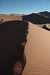
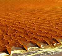
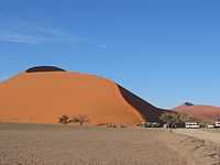
"This astronaut photo shows sand heaped up in numerous star dunes, each of them with long arms extending in several directions. Unlike crescent-shaped barchan dunes, which form in areas where winds generally blow from one direction, star dunes are apparently generated where winds are variable. In this part of the Namib Sand Sea, winds are mainly from the south, but easterly winds, channeled along the Tsauchab valley, provide another component. And warm dry winter winds—similar to the Santa Ana winds of California—blow from the northeast."[22]
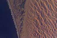
At right is an image from LandSat 7 of the Namib Desert. "Namib-Naukluft National Park is an ecological preserve in Namibia's vast Namib Desert. Coastal winds create the tallest sand dunes in the world here, with some dunes reaching 980 feet (300 meters) in height."[23]
Crevasse fillings
"Brúarjökull is the largest outlet glacier of the great Vatnajökull ice cap [in Iceland]. [...] Two large glacial rivers flow from Brúarjökull, Jökulsá á Dal and Kreppa, but numerous smaller rivers and banks drain meltwater from the glacier in spring and summer."[24]
"The present Brúarjökull ice margin is largely inactive (dead), and rapidly downwasting."[24]
As a result of the rapid downwasting, there are fields such as the one shown in the image on the right where the debris that filled crevasses now forms small ridges on the former subglacial surface. Note the pattern of such small ridges on the right and compare this with crevasse images in glaciology.
Levees
Def. an elongated naturally occurring ridge or "steep bank of a river"[25] is called a levee, or natural levee.
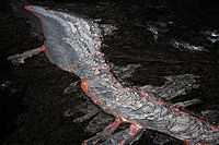
Pāhoehoe Lava flows in the open lava channel (not in a Lava tube) with overflows at both sides. The image on the left was taken at The Big Island of Hawaii. The lava flow is due to July 21, 2007, fissure eruption at Kīlauea volcano. The channel is crusting over with a v-shaped opening pointing upstream. The crusting-over process usually starts at the upstream end, the crust grows downstream for a considerable distance, then the crust founders and sinks opening the channel to crusting over again. The main channel and overflows show perched nature of this kind of lava channels. The picture was taken from a helicopter.
Reefs
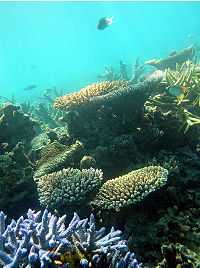
Def. a "chain or range of rocks, sand, or coral lying at or near the surface of the water"[26] is called a reef.
Def. a "mound or hummock of compacted coral skeletons"[27] is called a coral reef.
The image on the left is an island with fringing coral reef off Yap, Micronesia.
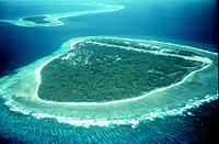
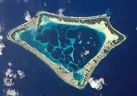
Def. a "type of island consisting of a ribbon reef that nearly or entirely surrounds a lagoon and supports, in most cases, one to many islets on the reef platform"[28] is called an atoll.
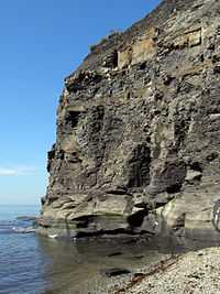
Cliffs
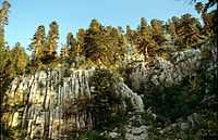
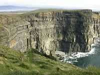
The cliff in the image on the right is part of a karst landscape formed by water and plants on calcareous (probably) limestone.
"This photo [on the left] shows clearly why these glacial deposits are called boulder clay, consisting as they are of clay and stones of various sizes up to and including large boulders. Till is another name for boulder clay."[29] The image is of an eroded boulder-clay cliff near to Trefor, Gwynedd, Great Britain.
Def. a "vertical (or nearly vertical) rock face"[30] is called a cliff.
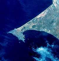
Promontories
Def. a "high point of land extending into a body of water, headland; cliff"[31] is called a promontory.
Headlands
.jpg)
Def. a "bit of coastal land that juts into the sea"[32] is called a headland.
Capes
Def. a "piece or point of land, extending beyond the adjacent coast into a sea or lake"[33] is called a cape.
Peninsulas
Def. a "piece of land projecting into water from a larger land mass"[34] is called a peninsula.
Glaciers
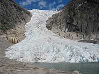
Def. "a mass of ice that originates on land, usually having an area larger than one tenth of a square kilometer"[16] is called a glacier.
Fans
Def. a "cone-shaped heap of alluvium deposited by a river"[35] is called an alluvial fan.
"A vast alluvial fan [in the image on the right] blossoms across the desolate landscape between the Kunlun and Altun mountain ranges that form the southern border of the Taklimakan Desert in China's XinJiang Province. The left side is the active part of the fan, and appears blue from water currently flowing in the many small streams. The image was acquired May 2, 2002, covers an area of 56.6 x 61.3 km, and is centered near 37.4 degrees north, 84.3 degrees east."[36]
Salt glaciers
"The diapirs, or salt plugs, in this image are a few of over 200 similar features scattered about this part of the Zagros Mountains in southern Iran. This region of folded rocks is the result of the collision between the Asian landmass and the Arabian platform. The deeper underlying deposits of salt have been reformed into ascending fluid-like, plastic plumes of salt. In some places these plumes have pushed through the overlying rock units, like toothpaste extruding from a tube, and are now visible as darkish irregular patches. Gravity has caused the salt to flow into adjacent valleys; the resulting tongue-shaped bodies, more than 5 km long, resemble glaciers, with arcuate ridges separated by crevasse-like gullies and with steep sides and fronts. The darker tones are due to clays brought up with the salt, as well as the probable accumulation of airborne dust. This ASTER perspective view [on the right] was created by draping a band 3-2-1 (RGB) image over an ASTER-derived DEM (2x vertical exaggeration), was acquired on August 10, 2001, and is located at 27.4 degrees north latitude and 54.6 degrees east longitude."[37]
Terraces
"Wave-cut terraces on San Clemente Island, California [are shown in the image on the right]. Nearly horizontal surfaces, separated by step-like cliffs, were created during former intervals of high sea level; the highest terrace represents the oldest sea-level high stand. Because San Clemente Island is slowly rising, terraces cut during an interglacial continue to rise with the island during the following glacial interval. When sea level rises during the next interglacial, a new wave-cut terrace is eroded below the previous interglacial terrace. Geologists can calculate the height of the former high sea levels by knowing the tectonic uplift rate of the island."[38]
Ice scours
Def. "a narrow ditch on a seabed caused by the movement of pack ice"[39] is called an ice scour.
Iceways
Def. a "linear channel eroded through bedrock by the passage of glacial ice"[40] is called an iceway.
Cols
Def. a "dip between mountain peaks in a summit-line"[41] is called a col.
Cirques
"A cirque is a bowl-shaped rock valley on the side of a mountain, often with a glacier or permanent snowfield in it. The glacier makes the cirque, by grinding an existing valley into a rounded shape with steep sides."[20]
Valleys
Def. an "elongated depression between hills or mountains"[42] is called a valley.
V-shaped valleys
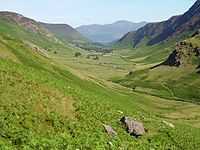
U-shaped valleys
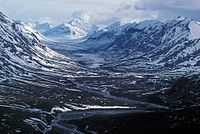
"As corrie [cirque] glaciers leave their source regions and descend down old river valleys they can make huge changes to the landscape. One of the major change they make is to the V-shaped valleys characteristic of the upper reaches of river valleys. The glaciers basically alter this V shape into a U, by creating a steep sided, wide valley in the shape of the letter U. They are formed by a valley glacier that moves down the valley because of gravity."[43]
"As the glacier moves down the valley it plucks the rock from beneath and those rocks then rub against the bed of the valley, eroding it further. This deepens and widens the valley. At the front end of the glacier it acts like a bulldozer, shifting and removing soil, plucking rock from interlocking spurs and truncating them. This creates Truncated Spurs, which are interlocking spurs without the land that interlocks! Originally, truncated spurs are created as a river erodes the upper valley it cuts down into the rock and meanders in and out of the surrounding rock. During glaciations this rock is removed by descending ice sheets."[43]
Canyons
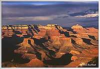
On the right is an example of a river canyon, specifically the Grand Canyon in Arizona, USA.
Def. a "valley, especially a long, narrow, steep valley, cut in rock by a river"[44] is called a canyon, or a river canyon.
Def. a deep gorge is called a canyon.
Gorges
Def. a narrow valley between hills or mountains is called a gorge.
Def. a "deep narrow passage with steep rocky sides; a ravine"[45] is called a gorge.
Gulfs
Def. a deep ravine, chasm, or abyss is called a gulf.
Def. a "hollow place in the earth; an abyss; a deep chasm or basin"[46] is called a gulf.
Plateaus
.png)
Def. a "largely level expanse of land at a high elevation; tableland"[47] is called a plateau.
Plains
Def. an "expanse of land with relatively low relief"[48] is called a plain.
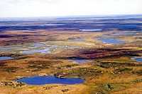
Outwash plains
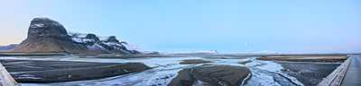
The center image shows the outwash plain on the western edge of Skeiðarársandur from the Vatnajökull icecap. Braided streams carry glacial sediment to the sea.
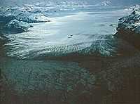
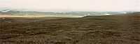
On the right is an image of the outwash plain in front of Brady Glacier in the Fairweather Range of Alaska.
Valley trains
Def. gravel "and sand [that] are deposited in bars to form a braided channel system "[49] is called a valley train.
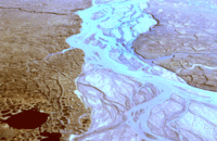
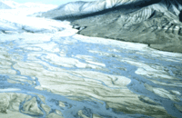
The "photo [on the left] shows summer meltwater issuing from a glacier on Bylot Island in eastern Canada."[49]
The "photo [on the right] shows the valley train further from the glacier margin. The interesting pattern shown in the lower left of the photo is patterned ground formed by freezing and thawing of the active layer in a permafrost area."[49]
Flats
Def. an "area of level ground"[50] is called a flat.
Def. any "land of relatively constant altitude"[51] is called a flatland.
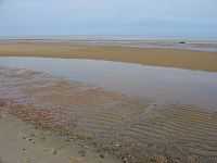
The first image on the right shows mudflats that extend hundreds of meters offshore at low tide.
The second image on the right shows a similar sized flatland where the local trees may be at least two meters high. Here, the flatland is on top of an extended butte often referred to as a plateau.
Ice sheets
For ice sheets the central portion is quite flat as shown in the image on the right of the Greenland ice sheet.
Def. "a dome-shaped mass of glacier ice that covers surrounding terrain and is greater than 50,000 square kilometers (12 million acres)"[16] is called an ice sheet.
Steppes
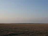
Def. a "vast cold, dry grass-plain"[52] is called a steppe.
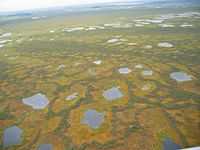
Tundra
Def. a cold, "flat and treeless" plain[53]is called a tundra.
Savanna
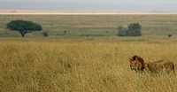
Def. a "tropical grassland with scattered trees"[54] is called a savanna.
Prairie
Def. an " extensive area of relatively flat grassland with few, if any, trees"[55] is called a prairie.
Velds
Def. an "open pasture land or grassland"[56] is called a veld.
Swamps
Def. a "piece of wet, spongy land; low ground saturated with water; soft, wet ground which may have a growth of certain kinds of trees, but is unfit for agricultural or pastoral purposes"[57] is called a swamp.
Flood plains
Def. an "alluvial plain that may or may not experience occasional or periodic flooding"[58] is called a flood plain.
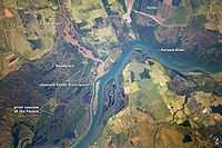
"The Paraná River appears as a wide, blue strip with the muddy brown water of the smaller Verde River entering from the northwest (top left). An extensive wetland (dark green) occupies most of the left half of this astronaut photograph, and the floodplain reaches a width of 11 kilometers (about 7 miles). The thin line of a road crossing the floodplain also gives a sense of scale. Above the Paraná-Verde confluence (image center), the floodplain is much narrower."[59]
"The floodplain is generated by sediments delivered by both rivers. The evidence for this is that the entire surface is crisscrossed by the wider traces of former Paraná River channels, as well as numerous narrower traces of the Verde. The floodplains along both rivers are bordered by numerous rectangular agricultural fields. The dominant crops along this part of the Paraná River are coffee, corn, and cotton."[59]
"Turbid water, such as that in the Verde River, is common in most rivers that drain plowed agricultural land, as some topsoil is washed into local rivers after rains. A long tendril of brown water extends from the Verde into the main channel of the Paraná, where it hugs the west bank and remains unmixed for many kilometers. This effectively shows the direction of river flow from orbit: right to left for the Paraná, and upper left to image center for the Verde."[59]
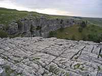
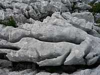
Pavements
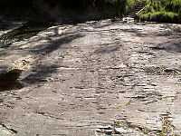
Def. a more or less horizontal, hard expanse of bare rock as a surface is called a pavement.
On the right are two images of a limestone pavement which is part of a karst topography.
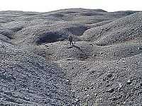
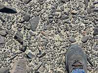
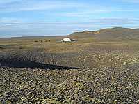
On the left is a desert pavement in southeastern California.
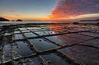
A pavement such as the one on the second left covered with pieces that are similarly shaped is referred to as a tessellated pavement.
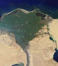
Deltas
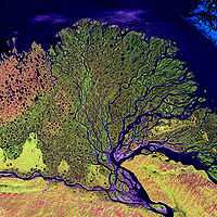
Def. "landform at the mouth of a river [shaped like the letter Δ] where it empties into a body of water"[60]
On the right is a Landsat multispectral image of the delta from the Lena River.
The delta of the Nile is on the left.
Continental shelves
![]()
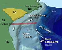
Def. an "area of sea around a land mass where the depth gradually increases before it plunges into the ocean deeps"[61] is called a continental shelf.
Abyssal plains
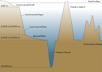
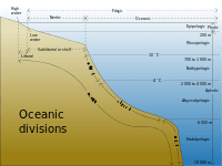
Def. "a large expanse of very flat and smooth ocean floor, usually found at depths of 4,600 to 5,500 meters (15,000 to 18,000 feet)"[62] is called an abyssal plain.
Kettles
"Kettle, also called Kettle Hole, in geology, [is a] depression in a glacial outwash drift made by the melting of a detached mass of glacial ice that became wholly or partly buried. The occurrence of these stranded ice masses is thought to be the result of gradual accumulation of outwash atop the irregular glacier terminus. Kettles may range in size from 5 m (15 feet) to 13 km (8 miles) in diameter and up to 45 m in depth. When filled with water they are called kettle lakes. Most kettles are circular in shape because melting blocks of ice tend to become rounded; distorted or branching depressions may result from extremely irregular ice masses."[63]
"Two types of kettles are recognized: a depression formed from a partially buried ice mass by the sliding of unsupported sediment into the space left by the ice and a depression formed from a completely buried ice mass by the collapse of overlying sediment. By either process, small kettles may be formed from ice blocks that were not left as the glacier retreated but rather were later floated into place by shallow meltwater streams. Kettles may occur singly or in groups; when large numbers are found together, the terrain appears as mounds and basins and is called kettle and kame topography."[63]
Geology
Def. the intellectual and practical activity encompassing the systematic study through observation and experiment of the Earth's physical structure and substance, its history and origin, and the processes that act on it, especially by examination of its rocks, is called geology.
Def. "the study of the planet earth- the materials it is made of, the processes that act on those materials, the products formed, and the history of the planet and its life forms since its origin"[64] is called geology.
Geography

Def.
a "study of the physical structure and inhabitants of the Earth"[65] or
a "physical structure of a particular region; terrain"[65] is called geography.
Def. "areal differentiation The varied nature of the earth's surface, as shown by the character, pattern and interrelationship of relief, climate, soil, vegetation, population, political units, etc., thus producing a mosaic of unique and dissimilar units. This is one definition of geography, partic. as propounded by R. Hartshorne."[66] is called geography.
Def. "the arrangement of things on the surface of the earth" is called geography, after A. Hettner.[66]
Def. "the study of the earth's surface in its areal differentiation as the home of Man"[66] is called geography.
Research
Hypothesis:
- A landform may have more than one origin.
Control groups

The findings demonstrate a statistically systematic change from the status quo or the control group.
“In the design of experiments, treatments [or special properties or characteristics] are applied to [or observed in] experimental units in the treatment group(s).[67] In comparative experiments, members of the complementary group, the control group, receive either no treatment or a standard treatment.[68]"[69]
Proof of concept
Def. a “short and/or incomplete realization of a certain method or idea to demonstrate its feasibility"[70] is called a proof of concept.
Def. evidence that demonstrates that a concept is possible is called proof of concept.
The proof-of-concept structure consists of
- background,
- procedures,
- findings, and
- interpretation.[71]
See also
References
- ↑ "landscape, In: Wiktionary". San Francisco, California: Wikimedia Foundation, Inc. October 6, 2013. Retrieved 2013-11-09.
- 1 2 3 4 5 6 7 8 9 10 11 12 13 14 15 16 Craig R. Sloss, Michael Shepherd & Patrick Hesp (2012). "Coastal Dunes: Geomorphology". Nature Education Knowledge 3 (10): 2. http://www.nature.com/scitable/knowledge/library/coastal-dunes-geomorphology-25822000. Retrieved 2014-11-27.
- ↑ Mike Buchheit (July 24, 2012). "Earthquake Glossary - geomorphology". Menlo Park, California USA: USGS. Retrieved 2014-12-03.
- ↑ "mountain range, In: Wiktionary". San Francisco, California: Wikimedia Foundation, Inc. 11 November 2014. Retrieved 2014-12-14.
- ↑ A. Amato and A. Cinque (December 1999). "Erosional landsurfaces of the Campano–Lucano Apennines (S. Italy): genesis, evolution, and tectonic implications". Tectonophysics 315 (1-4): 251-67. doi:10.1016/S0040-1951(99)00288-7. http://www.sciencedirect.com/science/article/pii/S0040195199002887. Retrieved 2014-11-10.
- ↑ "mountain, In: Wiktionary". San Francisco, California: Wikimedia Foundation, Inc. Retrieved 2014-12-14.
- ↑ "seamount, In: Wiktionary". San Francisco, California: Wikimedia Foundation, Inc. 8 October 2013. Retrieved 2014-12-18.
- ↑ "arête, In: Wiktionary". San Francisco, California: Wikimedia Foundation, Inc. 22 June 2014. Retrieved 2014-11-07.
- 1 2 Benjamin J.C. Laabs and Eric C. Carson (2005). Dehler, C.M., Pederson, J.L., Sprinkel, D.A., and Kowallis, B.J.. ed. Glacial Geology of the Southern Uinta Mountains, In: Uinta Mountain geology. 33. Utah Geological Association. 235-53. http://www.geology.wisc.edu/~davem/abstracts/05-20.pdf. Retrieved 2014-11-08.
- 1 2 3 4 Eleyne Phillips (16 December 2004). "Glossary of Glacier Terminology". Reston, Virginia USA: United States Geological Survey. Retrieved 2014-11-09.
- ↑ "butte, In: Wiktionary". San Francisco, California: Wikimedia Foundation, Inc. 11 August 2014. Retrieved 2014-12-14.
- ↑ SemperBlotto (18 August 2006). "guyot, In: Wiktionary". San Francisco, California: Wikimedia Foundation, Inc. Retrieved 2014-12-18.
- ↑ "hill, In: Wiktionary". San Francisco, California: Wikimedia Foundation, Inc. 28 November 2014. Retrieved 2014-12-14.
- ↑ Michael Hambrey (22 March 2007). "Shaping the landscape". SwissEducation. Retrieved 2014-12-14.
- ↑ "drumlin, In: Wiktionary". San Francisco, California: Wikimedia Foundation, Inc. 15 August 2014. Retrieved 2014-11-06.
- 1 2 3 4 5 6 7 Janet Beitler (2014). "Cryosphere Glossary". National Snow and Ice Data Center. Retrieved 2014-09-20.
- ↑ "hummock, In: Wiktionary". San Francisco, California: Wikimedia Foundation, Inc. 11 April 2014. Retrieved 2014-11-26.
- ↑ "kame, In: Wiktionary". San Francisco, California: Wikimedia Foundation, Inc. 15 April 2014. Retrieved 2014-12-14.
- 1 2 3 4 Adrian Hall (20 February 2014). "Kame". Landforms.eu. Retrieved 2014-12-14.
- 1 2 Hunter (November 2014). "Esker: Northern Manitoba, Canada". New York, NY USA: CUNY. Retrieved 2014-11-24.
- ↑ "dune, In: Wiktionary". San Francisco, California: Wikimedia Foundation, Inc. 12 November 2014. Retrieved 2014-11-27.
- ↑ Astronaut photograph (December 24, 2009). "TSAUCHAB RIVER AND SOSSUS VLEI LAKEBED, NAMIBIA". Washington, DC USA: NASA. Retrieved 2014-03-04.
- ↑ Charles Ichoku (September 23, 2002). "Namib-Naukluft National Park, Namibia". Washington, DC USA: NASA. Retrieved 2014-03-04.
- 1 2 Ó. Ingólfsson (2004). "Brúarjökull Photos". Iceland: Brúarjökull Project. Retrieved 2014-11-26.
- ↑ "levee, In: Wiktionary". San Francisco, California: Wikimedia Foundation, Inc. 16 December 2014. Retrieved 2014-12-18.
- ↑ "reef, In: Wiktionary". San Francisco, California: Wikimedia Foundation, Inc. 15 December 2014. Retrieved 2014-12-20.
- ↑ "coral reef, In: Wiktionary". San Francisco, California: Wikimedia Foundation, Inc. 6 December 2014. Retrieved 2014-12-20.
- ↑ "atoll, In: Wiktionary". San Francisco, California: Wikimedia Foundation, Inc. 21 October 2014. Retrieved 2014-12-20.
- ↑ Eric Jones (2008). "An eroded boulder clay cliff". Geograph.org. Retrieved 2014-12-04.
- ↑ "cliff, In: Wiktionary". San Francisco, California: Wikimedia Foundation, Inc. 9 October 2014. Retrieved 2014-12-18.
- ↑ "promontory, In: Wiktionary". San Francisco, California: Wikimedia Foundation, Inc. 25 May 2014. Retrieved 2014-12-20.
- ↑ "headland, In: Wiktionary". San Francisco, California: Wikimedia Foundation, Inc. 16 December 2014. Retrieved 2014-12-20.
- ↑ "cape, In: Wiktionary". San Francisco, California: Wikimedia Foundation, Inc. 15 December 2014. Retrieved 2014-12-20.
- ↑ "peninsula, In: Wiktionary". San Francisco, California: Wikimedia Foundation, Inc. 8 December 2014. Retrieved 2014-12-20.
- ↑ "alluvial fan, In: Wiktionary". San Francisco, California: Wikimedia Foundation, Inc. 8 September 2014. Retrieved 2014-12-17.
- ↑ Howard Tan (May 2, 2002). "Alluvial Fan, China". Pasadena, California USA: NASA/JPL. Retrieved 2014-12-17.
- ↑ Howard Tan (January 14, 2004). "Salt Glaciers, Iran". Pasadena, California USA: NASA/JPL. Retrieved 2014-12-18.
- ↑ Richard Z. Poore, Richard S. Williams, Jr., and Christopher Tracey (2000). "Sea Level and Climate". Reston, Virginia USA: United States Geological Survey. Retrieved 2014-11-22.
- ↑ "ice scour, In: Wiktionary". San Francisco, California: Wikimedia Foundation, Inc. 20 June 2013. Retrieved 2015-02-15.
- ↑ "iceway, In: Wiktionary". San Francisco, California: Wikimedia Foundation, Inc. 23 May 2014. Retrieved 2015-02-15.
- ↑ "col, In: Wiktionary". San Francisco, California: Wikimedia Foundation, Inc. 22 August 2014. Retrieved 2014-11-09.
- ↑ "valley, In: Wiktionary". San Francisco, California: Wikimedia Foundation, Inc. 8 December 2014. Retrieved 2014-12-15.
- 1 2 Rob Gamesby (6 September 2013). "Glacial Landforms". St-Marys Newcastle School, UK: Coolgeography.com. Retrieved 2014-11-07.
- ↑ "canyon, In: Wiktionary". San Francisco, California: Wikimedia Foundation, Inc. 21 October 2014. Retrieved 2014-12-18.
- ↑ "gorge, In: Wiktionary". San Francisco, California: Wikimedia Foundation, Inc. 16 December 2014. Retrieved 2014-12-18.
- ↑ "gulf, In: Wiktionary". San Francisco, California: Wikimedia Foundation, Inc. 7 July 2014. Retrieved 2014-12-18.
- ↑ SemperBlotto (12 September 2005). "plateau, In: Wiktionary". San Francisco, California: Wikimedia Foundation, Inc. Retrieved 2014-12-14.
- ↑ "plain, In: Wiktionary". San Francisco, California: Wikimedia Foundation, Inc. 28 November 2014. Retrieved 2014-11-30.
- 1 2 3 Richard C. Berg (2014). "Valley Trains". 615 E. Peabody, Champaign, IL 61820 USA: Illinois State Geological Survey. Retrieved 2014-12-11.
- ↑ "flat, In: Wiktionary". San Francisco, California: Wikimedia Foundation, Inc. 15 December 2014. Retrieved 2014-12-15.
- ↑ "flatland, In: Wiktionary". San Francisco, California: Wikimedia Foundation, Inc. 23 May 2014. Retrieved 2014-12-15.
- ↑ "steppe, In: Wiktionary". San Francisco, California: Wikimedia Foundation, Inc. 5 October 2014. Retrieved 2014-12-15.
- ↑ "tundra, In: Wiktionary". San Francisco, California: Wikimedia Foundation, Inc. 14 December 2014. Retrieved 2014-12-15.
- ↑ "savanna, In: Wiktionary". San Francisco, California: Wikimedia Foundation, Inc. 4 August 2014. Retrieved 2014-12-15.
- ↑ "prairie, In: Wiktionary". San Francisco, California: Wikimedia Foundation, Inc. 23 June 2010. Retrieved 2014-12-15.
- ↑ "veld, In: Wiktionary". San Francisco, California: Wikimedia Foundation, Inc. 25 May 2014. Retrieved 2014-12-15.
- ↑ "swamp, In: Wiktionary". San Francisco, California: Wikimedia Foundation, Inc. 6 December 2014. Retrieved 2014-12-18.
- ↑ "floodplain, In: Wiktionary". San Francisco, California: Wikimedia Foundation, Inc. 8 September 2014. Retrieved 2014-12-18.
- 1 2 3 M. Justin Wilkinson (March 19, 2012). "Paraná River Floodplain, Brazil". Washington, DC USA: NASA. Retrieved 2014-12-18.
- ↑ "delta, In: Wiktionary". San Francisco, California: Wikimedia Foundation, Inc. 4 December 2014. Retrieved 2014-12-16.
- ↑ SemperBlotto (9 September 2006). "continental shelf, In: Wiktionary". San Francisco, California: Wikimedia Foundation, Inc. Retrieved 2015-05-17.
- ↑ Mike5816 (16 March 2008). "abyssal plain, In: Wiktionary". San Francisco, California: Wikimedia Foundation, Inc. Retrieved 2015-05-17.
- 1 2 Amy Tikkanen (23 June 2010). "Kettle". Encyclopaedia Britannica. Retrieved 2014-12-12.
- ↑ Justin Gould (July 18, 2012). "Earthquake Glossary - geology". Menlo Park, California USA: USGS. Retrieved 2014-12-03.
- 1 2 "geography, In: Wiktionary". San Francisco, California: Wikimedia Foundation, Inc. 4 December 2014. Retrieved 2014-12-15.
- 1 2 3 Francis John Monkhouse (November 30, 2007). A Dictionary of Geography, Second Edition. Transaction Publishers. pp. 378. ISBN 0202361314. http://books.google.com/books?id=9yhhzHMnnyoC&lr=&source=gbs_navlinks_s. Retrieved 2012-05-24.
- ↑ Klaus Hinkelmann, Oscar Kempthorne (2008). Design and Analysis of Experiments, Volume I: Introduction to Experimental Design (2nd ed.). Wiley. ISBN 978-0-471-72756-9. http://books.google.com/?id=T3wWj2kVYZgC&printsec=frontcover.
- ↑ R. A. Bailey (2008). Design of comparative experiments. Cambridge University Press. ISBN 978-0-521-68357-9. http://www.cambridge.org/uk/catalogue/catalogue.asp?isbn=9780521683579.
- ↑ "Treatment and control groups, In: Wikipedia". San Francisco, California: Wikimedia Foundation, Inc. May 18, 2012. Retrieved 2012-05-31.
- ↑ "proof of concept, In: Wiktionary". San Francisco, California: Wikimedia Foundation, Inc. November 10, 2012. Retrieved 2013-01-13.
- ↑ Ginger Lehrman and Ian B Hogue, Sarah Palmer, Cheryl Jennings, Celsa A Spina, Ann Wiegand, Alan L Landay, Robert W Coombs, Douglas D Richman, John W Mellors, John M Coffin, Ronald J Bosch, David M Margolis (August 13, 2005). "Depletion of latent HIV-1 infection in vivo: a proof-of-concept study". Lancet 366 (9485): 549-55. doi:10.1016/S0140-6736(05)67098-5. http://www.ncbi.nlm.nih.gov/pmc/articles/PMC1894952/. Retrieved 2012-05-09.
External links
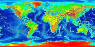
- Bathymetry and Global Relief of Earth
- NASA's Earth Observatory Glossary
- NOAA's National Ocean Service
- NOAA's Ocean Explorer
![]() This is a research project at http://en.wikiversity.org
This is a research project at http://en.wikiversity.org
| |
Development status: this resource is experimental in nature. |
| |
Educational level: this is a research resource. |
| |
Subject classification: this is a Geology resource. |
| |
Subject classification: this is a geography resource . |