Geology
At its earliest, geology is the study of the rocks that compose the astronomical rocky object referred to as the Earth.
Whether the earliest hominins conceived of the Earth as approximating a spheroidal rocky object is unknown.
Radioactivity
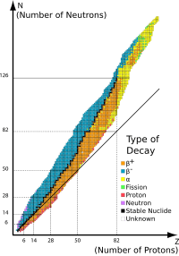

Def. a spontaneous emission of an α ray, β ray, or γ ray by the disintegration of an atomic nucleus is called radioactivity.[1]
"Although alpha, beta, and gamma radiations were found most commonly, other types of decay were eventually discovered. Shortly after the discovery of the positron in cosmic ray products, it was realized that the same process that operates in classical beta decay can also produce positrons (positron emission). In an analogous process, instead of emitting positrons and neutrinos, some proton-rich nuclides were found to capture their own atomic electrons (electron capture), and emit only a neutrino (and usually also a gamma ray). Each of these types of decay involves the capture or emission of nuclear electrons or positrons, and acts to move a nucleus toward the ratio of neutrons to protons that has the least energy for a given total number of nucleons (neutrons plus protons)."[2]
"Radioactive decay is a stochastic (i.e., random) process at the level of single atoms, in that, according to quantum theory, it is impossible to predict when a particular atom will decay.[3] However, the chance that a given atom will decay is constant over time. For a large number of atoms, the decay rate for the collection is computable from the measured decay constants of the nuclides (or equivalently from the half-lifes)."[2]
"Radioactive primordial nuclides found in the Earth are [probably] residues from ancient supernova explosions which occurred before the formation of the solar system. They [may be] the long-lived fraction of radionuclides surviving in the primordial solar nebula through planet accretion until the present. The naturally occurring short-lived radiogenic radionuclides found in rocks [may be] the daughters of these [radioactive] primordial nuclides. Another minor source of naturally occurring radioactive nuclides are cosmogenic nuclides, formed by cosmic ray bombardment of material in the Earth's atmosphere or crust. ... Radionuclides can also be produced artificially e.g. using particle accelerators or nuclear reactors."[2]
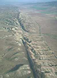
"Although the Earth's field is generally well approximated by a magnetic dipole with its axis near the rotational axis, there are occasional dramatic events where the North and South geomagnetic poles trade places. These events are called geomagnetic reversals. Evidence for these events can be found worldwide in basalts, sediment cores taken from the ocean floors, and seafloor magnetic anomalies. Reversals occur at apparently random intervals ranging from less than 0.1 million years to as much as 50 million years. The most recent such event, called the Brunhes–Matuyama reversal, occurred about 780,000 years ago.[4][5]"[6]
The longer the period of geomagnetic reversal the longer the Earth's surface rocks receive a heightened exposure to solar and galactic cosmic rays that in turn may make these rocks appear older than they are.
Planetary sciences
Planetary science studies astronomical objects that are in orbit around another object within a few light years. The effects on these astronomical objects of being in an orbit is the principal thrust.
Colors
The rocks, regolith, and sediment of the Earth reflect colors and a variety of radiation.
Minerals
Minerals are solid inorganic substances of natural occurrence.
Mineralogy
Def. the scientific study of minerals is called mineralogy.
Alkali metal minerals
Various minerals contain significant amounts of the alkali metals: Li, Na, K, Rb, and Cs. Trace amounts of Fr occur.
Alkaline earth metal minerals
The elements Be, Mg, Ca, Sr, Ba, and Ra are common in minerals such as calcite which makes up rocks such as limestone and dolomite.
Chalcogen minerals
The chalcogen minerals contain significant quantities of oxygen, sulfur, selenium, tellurium and polonium. Quartz is composed of SiO2. Two atoms of oxygen are present for one atom of silicon.
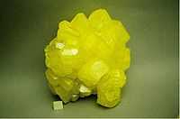
Native sulfur is a naturally occurring chalcogen mineral.
Def. "a continuous framework [tectosilicate] of SiO4 silicon–oxygen tetrahedra, with each oxygen being shared between two tetrahedra, giving an overall [chemical] formula [of] [silicon dioxide] SiO2 ... [of] trigonal trapezohedral class 3 2"[7], usually with some substitutional or interstitial impurities, is called α-quartz.
Gems
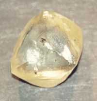
Many minerals occur in large enough crystals to be considered gems.
Def. a "precious stone, usually of substantial monetary value or prized for its beauty or shine"[8] is called a gem.
Def. the "art and science of gems"[9] is called gemology.
Halogen minerals

Def. any "element of group 7, i.e. fluorine, chlorine, bromine, iodine and astatine, which form a salt by direct union with a metal"[10] is called a halogen.
Fluorite is a mineral composed of NaF.
Metal minerals
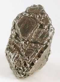
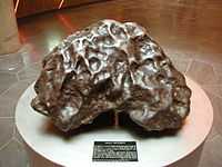
Def. any "of a number of chemical elements in the periodic table that form a metallic bond with other metal atoms; generally shiny, somewhat malleable and hard, often a conductor of heat and electricity"[11] is called a metal. "Kamacite is an alloy of iron and nickel, which is only found on earth in meteorites. The proportion iron:nickel is between 90:10 to 95:5; small quantities of other elements, such as cobalt or carbon may also be present. The mineral has a metallic luster, is gray and has no clear cleavage although the structure is isometric-hexoctahedral. Its density is around 8 g/cm³ and its hardness is 4 on the Mohs scale. It is also sometimes called balkeneisen."[12]
Precious metal minerals
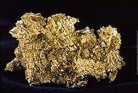
Def. a "rare metallic chemical element of high economic value"[13] is called a precious metal.
Rare earth minerals
Def. "naturally occurring oxides of the lanthanide metals"[14] are called rare earths.
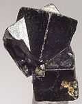
"Thorianite is a rare thorium oxide mineral, ThO2.[15] ... [It has a] high percentage of thorium; it also contains the oxides of uranium, lanthanum, cerium, praseodymium and neodymium. ... the mineral is slightly less radioactive than pitchblende, but is harder to shield due to its high energy gamma rays. It is common in the alluvial gem-gravels of Sri Lanka, where it occurs mostly as water worn, small, heavy, black, cubic crystals."[16]
Silicate minerals
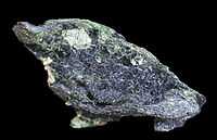
Often a mineral appears blue due to the presence of copper or sulfur. Glaucophane is a blue silicate that owes its color to its characteristic formation.
Def. any "salt of silica or of one of the silicic acids"[17] is called a silicate.
Def. any group of silicates that have structurally isolated double tetrahedra is called a sorosilicate.
Def. any group of silicates that have a ring of linked tetrahedra is called a cyclosilicate.
"Mineralogically, silicate minerals are divided according to structure of their silicate anion into the following groups:[18][19]"[20]
- Nesosilicates (lone tetrahedron) - [SiO4]4−, e.g. olivine, tephroite.
- Sorosilicates (double tetrahedra) - [Si2O7]6−, e.g. epidote, melilite group, leucophanite.
- Cyclosilicates (rings) - [SinO3n]2n−, e.g. tourmaline group.
- Inosilicates (single chain) - [SinO3n]2n−, e.g. pyroxene group.
- Inosilicates(double chain) - [Si4nO11n]6n−, e.g. amphibole group.
- Phyllosilicates (sheets) - [Si2nO5n]2n−, e.g. micas and clays like Kaolin.
- Tectosilicates (3D framework) - [AlxSiyO2(x+y)]x−, e.g. quartz, feldspars, zeolites.
Def. the "oxyanion of silicon SiO32- or any salt or mineral containing this ion"[21] is called a metasilicate.
Transuranic minerals
Def. any naturally occurring element "lying beyond uranium in the periodic table; having an atomic number greater than 92"[22] is called a transuranic.
Crystallography
Def. an "experimental science of determining the arrangement of atoms in solids"[23], or the "study of crystals"[23] is called crystallography.
Mineraloids
Def. "[a] substance that resembles a mineral but does not exhibit crystallinity"[24] is called a mineraloid.
Def. "[a] small, round, dark glassy object, composed of silicates"[25] is called a tektite.
Def. "[a] hard, generally yellow to brown translucent fossil resin"[26] is called an amber.
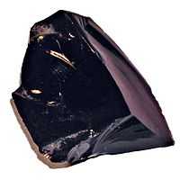
Def. a naturally occurring black glass is called an obsidian.
Def. a naturally occurring, hydrous, "amorphous form of silica, ... [where] 3% to 21% of the total weight is water"[27] is called an opal.
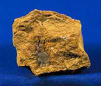
"Limonite is an iron ore consisting of a mixture of hydrated iron(III) oxide-hydroxides in varying composition. The generic formula is frequently written as FeO(OH)·nH2O, although this is not entirely accurate as the ratio of oxide to hydroxide can vary quite widely. Limonite is one of the two principle iron ores, the other being hematite, and has been mined for the production of iron since at least 2500 BCE.[28][29] ... Although originally defined as a single mineral, limonite is now recognized as a mixture of related hydrated iron oxide minerals, among them goethite, akaganeite, lepidocrocite, and jarosite. Individual minerals in limonite may form crystals, but limonite does not, although specimens may show a fibrous or microcrystalline structure,[30] and limonite often occurs in concretionary forms or in compact and earthy masses; sometimes mammillary, botryoidal, reniform or stalactitic. Because of its amorphous nature, and occurrence in hydrated areas limonite often presents as a clay or mudstone. However there are limonite pseudomorphs after other minerals such as pyrite.[31] This means that chemical weathering transforms the crystals of pyrite into limonite by hydrating the molecules, but the external shape of the pyrite crystal remains. Limonite pseudomorphs have also been formed from other iron oxides, hematite and magnetite; from the carbonate siderite and from iron rich silicates such as almandine garnets. ... Limonite usually forms from the hydration of hematite and magnetite, from the oxidation and hydration of iron rich sulfide minerals, and chemical weathering of other iron rich minerals such as olivine, pyroxene, amphibole, and biotite. It is often the major iron component in lateritic soils. ... One of the first uses was as a pigment. The yellow form produced yellow ochre for which Cyprus was famous,[32]."[33]
Theoretical geology
Def. the intellectual and practical activity encompassing the systematic study through observation and experiment of the Earth's physical structure and substance, its history and origin, and the processes that act on it, especially by examination of its rocks, is called geology.
Def. "the study of the planet earth- the materials it is made of, the processes that act on those materials, the products formed, and the history of the planet and its life forms since its origin"[34] is called geology.
Def. a "layer of loose rock, dust, sand, and soil, resting on the bedrock"[35] is called a regolith.
Entities

Def. any "considerable and connected part of a [...] tract of land [...] of considerable but indefinite extent [...,] in a broad sense, a place without special reference to location or extent but viewed as an entity"[36] is called a region.
Sources
Geological sources may be fluid substances.
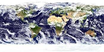
The scene on the right was acquired by the Moderate Resolution Imaging Spectroradiometer (MODIS), flying aboard NASA’s Terra satellite, on October 23, 2002.
Objects
The image on the right shows calcite after Ikaite variety Glendonite as a concretion in this rock found on the Kola Peninsula, Russia.
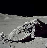
An object in geology may be as simple as a stone or as complex as a product of orogeny.
Def. "the process of mountain building by the upward folding of the Earth's crust"[37] is called orogeny.
Gravity
Def. resultant "force on Earth's surface, of the attraction by the Earth's masses, and the centrifugal pseudo-force caused by the Earth's rotation"[38] is called gravity.
Most objects on the surface of the Earth appear to fall to lower elevations whenever possible. Hydrogen gas molecules (H2) and helium (He) atoms do not fall.
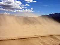
Meteors
Some meteors pass through the Earth's atmosphere but keep on going. Others impact the Earth as meteorites.
The largest known, or suspected, meteorites were asteroids.
Visuals

Def. a "portion of land or territory which the eye can comprehend in a single view, including all the objects it contains"[39] is called a landscape.
Def. each continuous surface of a landscape that is observable in its entirety and has consistence of form or regular change of form is called a landform.
Inert gas minerals
Def. any "of the elements of group 18 of the periodic table, being monatomic and (with very limited exceptions) inert"[40] is called a noble gas.
The elemental noble gases are helium, neon, argon, krypton, xenon, and radon. These occur from the radioactive decay of other elements. Various trace levels of these gases occur in minerals. Helium is often recovered from traps above salt domes.
"Confirmation of the source of excess argon comes from step-heating experiments on multiple anorthoclase aliquots separated from two phenocrysts and one glass aliquot prepared from the matrix of a volcanic bomb."[41]
Liquid objects
Water occurs on land, composes the oceans, becomes ice and forms clouds. All of these are part of hydrology.
Def. a naturally occurring, silvery-colored, metallic liquid, composed primarily of the chemical element mercury, is called mercury, or native mercury.
Native mercury (Hg) occurs as a liquid. Gallium (Ga) melts just above room temperature.
Hydrology
Def. the "science of the properties, distribution, and effects of water on a planet's surface, in the soil and underlying rocks, and in the atmosphere"[42] is called hydrology.
Geohydrology
The discoveries of the locations of water may be thought of as geohydrology.
Hydromorphology
Hydromorphology is the science of the shapes and forms of water on Earth.
Oceans
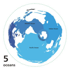
Def. On Earth one "of the five large bodies of water separating the continents"[43] is called an ocean.
Oceanography
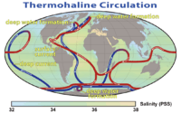
"Oceanography ..., also called oceanology or marine science, ... studies the ocean. It covers a wide range of topics, including marine organisms and ecosystem dynamics; ocean currents, waves, and geophysical fluid dynamics; plate tectonics and the geology of the sea floor; and fluxes of various chemical substances and physical properties within the ocean and across its boundaries."[44]
Petroleums
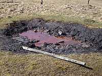
Def. "[a] flammable liquid ranging in color from clear to very dark brown and black, consisting mainly of hydrocarbons"[45] is called petroleum.
Rocky objects

Def. "[f]ull of, or abounding in, rocks; consisting of rocks"[46] is called rocky.
Def. a solid, or rocky, surface of an astronomical rocky object is called land.
Def.
- a "single, distinctive rock formation",[47]
- "an area having a preponderance of a particular rock or group of rocks",[47] or
- an "area of land or the particular features of it"[47]
is called a terrain.
Def. the "physical structure of a particular region [or] terrain"[48] is called geography.
Coals
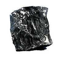
Def. a "black rock formed from prehistoric plant remains, composed largely of carbon and burned as a fuel"[49] is called a coal.
Types of coal include: "bituminous, anthracite, or lignite, and grades and varieties thereof."[49]
Ices
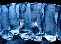
Def. any frozen "volatile chemical, such as water, ammonia, or carbon dioxide"[50] is called an ice.
Ice cores
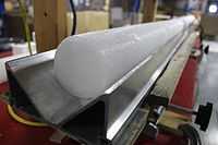
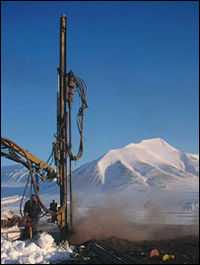
An ice core is a cylindrical sample of a rocky object consisting mostly of water ice. As shown in the image at the right, the long axis is in the direction of the coring into the object from its outer surface.
An ice core is taken with a hollow drill supported by a rig.
Def. "a core sample drilled from the accumulation of snow and ice over many years that have recrystallized and have trapped air bubbles from previous time periods, the composition of which can be used to reconstruct past climates and climate change; typically removed from an ice sheet (Antarctica and Greenland) or from high mountain glaciers elsewhere"[51] is called an ice core.
Ice sheets
Def. "a dome-shaped mass of glacier ice that covers surrounding terrain and is greater than 50,000 square kilometers (12 million acres)"[51] is called an ice sheet.
Astroglaciology

Astroglaciology is the observation and interpretation of glacial structures on rocky objects such as Ganymede from above.
Rocks
Def. "[a]ny natural material with a distinctive composition of minerals"[52] is called a rock.
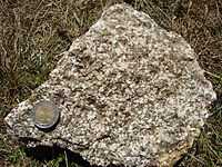
Igneous rocks
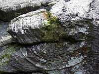
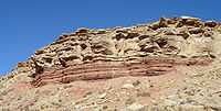
A rhyolite boulder on the right near Carn Alw shows the characteristic pattern of swirling or parallel layers called flow banding caused by the molten magma meeting a hard surface before cooling and setting.
Def. a group of rocks "formed by the cooling of molten rock, either below the surface (intrusive) or on the surface (extrusive)"[53] is called an igneous rock.
Volcanology
Volcanology is the scientific study of volcanoes.
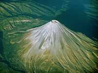
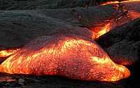
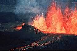
Volcanoes
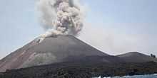
An eruption of Mount Asama in Tsumagoi, about 140 km (87 miles) northwest of Tokyo, is imaged.
On the left is a lava flow. Lava is an extrusive form of magma.
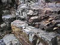
Tephra layers
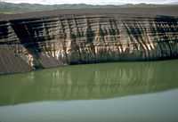
The rhythmically layered, dark gray material visible in the wall on the right consists of more than 15 m (50 ft) of phreatomagmatic tephra. The 1977 tephra sits on an exposure of glacial till capping ash-flow deposits from the Ugashik Caldera.
Magmas
Def. "molten matter within the earth"[54] is called magma.
Def. a "fine-grained igneous rock composed mostly of pyroxene and feldspar"[55] is called a diabase.
Metamorphism
Def. a "process by which rocks are changed into other forms"[56] is called metamorphism.
Metamorphic rocks
Def. a group of rocks that ... "consists of pre-existing rock mass in which new minerals or textures are formed"[57] is called a metamorphic rock.
Sedimentology
"Sedimentology encompasses the study of modern sediments such as sand,[58] mud (silt),[59] and clay,[60] and the processes that result in their deposition.[61]"[62]
Soil science
Pedology is concerned with the formation, nature, ecology, and classification of soils.
Sedimentary rocks
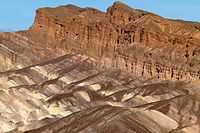
"Sedimentary rocks cover most of the Earth's surface, record much of the Earth's history, and harbor the fossil record. Sedimentology is closely linked to stratigraphy, the study of the physical and temporal relationships between rock layers or strata."[62]
Def. a group of rocks "formed by the deposition of either the weathered remains of other rocks, the results of biological activity, or precipitation from solution"[63] is called a sedimentary rock.
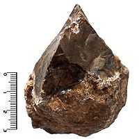
Meteorites
Meteorites occur over all the Earth's surface but are only easily found or preserved in specific environments.
Def. "a meteor that reaches the surface of the Earth without being completely vaporized" is called a meteorite.[1]
Def. "[a] metallic or stony object or body that is the remains of a meteor"[65] is called a meteorite.
Micrometeorites
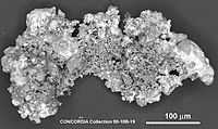
Micrometeorite is often abbreviated as MM. Most MMs are broadly chondritic in composition, meaning "that major elemental abundance ratios are within about 50% of those observed in carbonaceous chondrites."[66] Some MMs are chondrites, (basaltic) howardite, eucrite, and diogenite (HED) meteorites or Martian basalts, but not lunar samples.[66] "[T]he comparative mechanical weakness of carbonaceous precursor materials tends to encourage spherule formation."[66] From the number of different asteroidal precursors, the approximate fraction in MMs is 70 % carbonaceous.[66] "[T]he carbonaceous material [is] known from observation to dominate the terrestrial MM flux."[66] The "H, L, and E chondritic compositions" are "dominant among meteorites but rare among micrometeorites."[66]
"Ureilites occur about half as often as eucrites (Krot et al. 2003), are relatively friable, have less a wide range of cosmic-ray exposure ages including two less than 1 Myr, and, like the dominant group of MM precursors, contain carbon."[66]
Glaciers
Hypothesis:
- Glaciers occur in every 10° of longitude around the globe and in every 5° of latitude from pole to pole.
Glaciology
Def. "[t]he study of ice and its effect on the landscape, especially the study of glaciers"[67] is called glaciology.
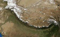
Planetary geology
"Planetary geology, ... astrogeology or exogeology, is a planetary science ... concerned with the geology of the celestial bodies such as the planets and their moons, asteroids, comets, and meteorites. ... [It includes] determining the internal structure of the terrestrial planets, ... planetary volcanism and surface processes such as impact craters, fluvial and aeolian processes."[68]
Planetary geology is primarily the study of the geologic effects on a rocky object due to its being in orbit within a few light years of another object.
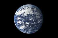
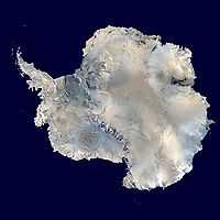
Earth
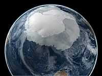
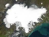
At the south pole, Antactica, there is also an extensive ice sheet [second image on the right]. Apparently, when the North polar sea ice and ice sheet has been contracting, the South polar sea ice and ice sheet has been expanding.
Rocky object Earth
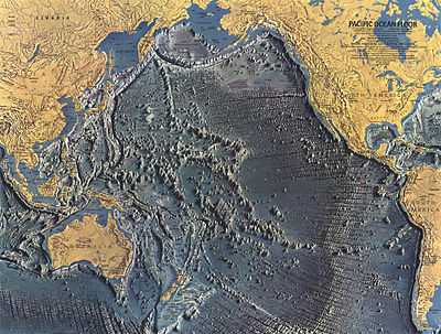
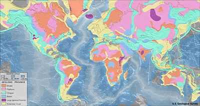
The Pacific Ocean covers almost half of the Earth's surface. Above is a map of the rocky-object features that form the bottom of the Pacific.
Craters
Metorites often create and occur within impact craters. But, meteorites are not the only moving objects that crater or gouge the Earth's surface or interior.
Speleology
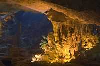
Def. a "scientific study of caves"[69] is called speleology.
Earth sciences
Def. any "of the sciences dealing with the planet Earth"[70] is called an earth science.
Economic geology
Def. a geology of Earth materials that are a focus for extractive industries is called economic geology.
Mining
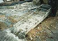
The image at right shows a sluice box for placer mining. This mining benefits from economic geology.
Def. an "activity of removing solid valuables from the earth"[71] is called mining.
Geochemistry
Geochemistry is the study of the chemical composition of the Earth and its rocks and minerals.
Geochronology
Def. the "science of dating samples of rock or sediment"[72] is called geochronology.
Geodesy
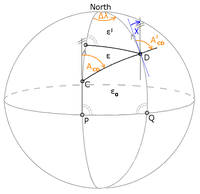
Def. "the geological science of the shape and size of the earth"[73] is called geodesy.
The image shows meridian convergence and spherical excess as part of geodesy.
Geodetics
Geodetics is geodesy as applied to land surveying.
Def. "the scientific discipline that deals with the measurement and representation of the earth, its gravitational field and geodynamic phenomena (polar motion, earth tides, and crustal motion) in three-dimensional, time-varying space"[74] is called geodetics.
Geognosy
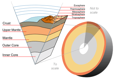
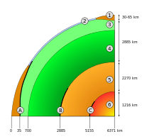
Def. a "geological study of the Earth's structure and composition"[75] is called a geognosy. Geology of the interior of Earth:
3. upper mantle
4. lower mantle
5. outer core
6. inner core
A: Mohorovičić discontinuity (Moho boundary)
C: Lehmann discontinuity (inner core-outer core boundary)
The Earth has an outer silicate solid crust, a highly viscous mantle, a liquid outer core that is much less viscous than the mantle, and a solid inner core. The Inner Core of the earth is believed to be composed primarily of a nickel-iron alloy, with very small amounts of some other elements.[76] The Outer Core of the earth is a liquid layer made of iron and nickel.
Geomorphology
Def. "[t]he study of landforms, their classification, origin, development, and history"[77] is called geomorphology.
Astrogeology
Def. the intellectual and practical activity encompassing the systematic study through observation and experiment of naturally occurring astronomical rocky objects, their physical structure and substance, history and origin, and the processes that act on them, especially by examination of their rocks, is called astrogeology.
Identifying the rocks, regoliths, and sediments on the solid surface of the Earth is often best accomplished from above the surface.
Geophysics
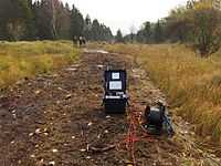
In the image at the right, geophysicists from the Department of Earth Science at Aarhus University perform electrical measurements (DC/IP) at Ulstrup in Denmark. Studerende fra Instituttet for Geologi ved Århus Universitet, der udfører geofysisk feltarbejde i Ulstrup nær Viborg.
Geophysics is the physics of the Earth.
Paleontology
Paleontology is the study of fossil animals and plants.
Def. the "[s]tudy of the forms of life existing in prehistoric or geologic times"[78] is called paleontology.
Petrology
Petrology is a branch of geology that studies rocks, and the conditions in which rocks form. Lithology focuses on macroscopic hand-sample or outcrop-scale description of rocks, while petrography deals with microscopic details. Petrology benefits from mineralogy, optical mineralogy, geochemistry, and geophysics. Three branches of petrology focus on the three major rock types: igneous petrology, metamorphic petrology, and sedimentary petrology.
Structural geology
"Structural geology is the study of the three-dimensional distribution of rock units with respect to their deformational histories."[79]
Geography
Geography, specifically physical geography, is the study of the physical features of the Earth and its atmosphere, and of human activity as it affects and is affected by these, including the distribution of populations and resources, land use, and industries.
Physical geography
Def. a "subfield of geography that studies physical patterns and processes of the Earth"[80] is called physical geography.
"It aims to understand the forces that produce and change rocks, oceans, weather, and global flora and fauna patterns."[80]
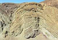
Stratigraphy
.jpg)
The image at the right shows rock strata in Cafayate, Argentina, the subject of stratigraphy.
Archeology
Archaeology "studies human cultures through the recovery, documentation and analysis of material remains and environmental data, including architecture, artifacts, ecofacts, human remains, and landscapes."[81]
Historical geology
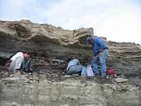
"Historical geology is a study of life forms represented in the fossil record, as well as the chronology of geologic processes."[82]
The image at the right shows two geochronologists and one paleontologist collecting ash at the Cretaceous-Paleogene Boundary in Wyoming, USA.
Geohistory
| Salé-Cypremort | 4600 years BP | |
| Cocodrie | 4600-3500 years BP | |
| Teche | 3500-2800 years BP | |
| St. Bernard | 2800-1000 years BP | |
| Lafourche | 1000-300 years BP | |
| Plaquemine | 750-500 years BP | |
| Balize | 550 years |
The image on the right shows the evolutionary history of the Mississippi delta.
Geohistory is the global evolution of the Earth.[83]
Quaternary
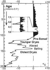
Def. the geology of the Quaternary period or system of deposits laid down during it is called Quaternary science.
The "whole change elapsed just opposite the course of events that characterized the great glacial oscillations with sudden warming followed by slow cooling. Therefore, the two phenomena hardly have the same cause."[84]
Seismology
Seismology is the study of earthquakes and related phenomena through the use of Earth vibrations.
Geoseismology
Geoseismology is the study of vibration in the Earth.
Technology

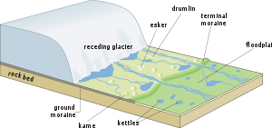
"Satellite imagery and data from ground surveys are used to reconstruct the integrated pattern of the principal longitudinal and transverse features produced on a continent-wide scale by the last ice sheets in Europe and North America."[85]
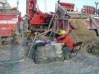
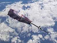
"Boreholes [made by rigs like that imaged at the right] in Svalbard, Norway, for example, indicate that ground temperatures rose 0.4C over the past decade, four times faster than they did in the previous century".[86] "Three [Swarm] satellites of the European Space Agency (ESA) have measured the magnetic field of Earth more precisely than ever before."[87]
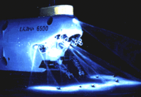
"Shinkai 6500, a Japanese research submarine built in 1989 [an artist's impression is on the left], can work at depths down to 6,400 m."[88]
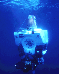
"Scientists discovered the hot-springs ecosystems with the help of Alvin [imaged on the right, third one], the world's first deep-sea submersible. Constructed in the early 1960s for the U.S. Navy, Alvin is a three-person, self-propelling capsule-like submarine nearly eight meters long. In 1975, scientists of Project FAMOUS (French-American Mid-Ocean Undersea Study) used Alvin to dive on a segment of the Mid-Atlantic Ridge in an attempt to make the first direct observation of seafloor spreading. No hot springs were observed on this expedition; it was during the next Alvin expedition, the one in 1977 to the Galapagos Rift, that the hot springs and strange creatures were discovered. Since the advent of Alvin, other manned submersibles have been built and used successfully to explore the deep ocean floor. Alvin has an operational maximum depth of about 4,000 m, more than four times greater than that of the deepest diving military submarine."[88]
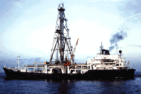
"The Glomar Challenger [imaged on the third right] was the first research vessel specifically designed in the late 1960s for the purpose of drilling into and taking core samples from the deep ocean floor."[88]
"In the years following World War II, continental oil reserves were being depleted rapidly and the search for offshore oil was on. To conduct offshore exploration, oil companies built ships equipped with a special drilling rig and the capacity to carry many kilometers of drill pipe. This basic idea later was adapted in constructing a research vessel, named the Glomar Challenger, designed specifically for marine geology studies, including the collection of drill-core samples from the deep ocean floor. In 1968, the vessel embarked on a year-long scientific expedition, criss-crossing the Mid-Atlantic Ridge between South America and Africa and drilling core samples at specific locations. When the ages of the samples were determined by paleontologic and isotopic dating studies, they provided the clinching evidence that proved the seafloor spreading hypothesis."[88]
"The JOIDES Resolution [in the fourth image on the right] is the deep-sea drilling ship of the 1990s (JOIDES= Joint Oceanographic Institutions for Deep Earth Sampling). This ship, which carries more than 9,000 m of drill pipe, is capable of more precise positioning and deeper drilling than the Glomar Challenger."[88]
Research Opportunities
Hypothesis:
- The volcanoes of Earth may have the same origin as the volcanoes of Io.
- Many or all the folded, jumbled, and displaced strata were moved and structurally altered by glacial surging.
See Research, Control group, and Proof of concept for more information.
See also
References
- 1 2 Philip B. Gove, ed (1963). Webster's Seventh New Collegiate Dictionary. Springfield, Massachusetts: G. & C. Merriam Company. pp. 1221.
- 1 2 3 "Radioactive decay, In: Wikipedia". San Francisco, California: Wikimedia Foundation, Inc. December 24, 2012. Retrieved 2012-12-25.
- ↑ "Decay and Half Life". Retrieved 2009-12-14.
- ↑ Merrill, McElhinny & McFadden 1996, Chapter 5
- ↑ Tony Phillips (December 29, 2003). "Earth's Inconstant Magnetic Field". Science@Nasa. Retrieved December 27, 2009.
- ↑ "Earth's magnetic field, In: Wikipedia". San Francisco, California: Wikimedia Foundation, Inc. December 21, 2012. Retrieved 2012-12-25.
- ↑ "Quartz, In: Wikipedia". San Francisco, California: Wikimedia Foundation, Inc. October 22, 2012. Retrieved 2012-10-23.
- ↑ "gem, In: Wiktionary". San Francisco, California: Wikimedia Foundation, Inc. 16 November 2014. Retrieved 2015-01-04.
- ↑ "gemology, In: Wiktionary". San Francisco, California: Wikimedia Foundation, Inc. 9 December 2014. Retrieved 2015-01-04.
- ↑ "halogen, In: Wiktionary". San Francisco, California: Wikimedia Foundation, Inc. 29 December 2014. Retrieved 2015-01-04.
- ↑ "metal, In: Wiktionary". San Francisco, California: Wikimedia Foundation, Inc. 2 January 2015. Retrieved 2015-01-04.
- ↑ "Kamacite, In: Wikipedia". San Francisco, California: Wikimedia Foundation, Inc. August 4, 2013. Retrieved 2013-09-01.
- ↑ "precious metal, In: Wiktionary". San Francisco, California: Wikimedia Foundation, Inc. 10 January 2014. Retrieved 2015-01-04.
- ↑ "rare earth, In: Wiktionary". San Francisco, California: Wikimedia Foundation, Inc. 6 June 2014. Retrieved 2015-01-04.
- ↑ C. Frondel (1958). Systematic Mineralogy of Uranium and Thorium. United States Government Printing Office.
- ↑ "Thorianite, In: Wikipedia". San Francisco, California: Wikimedia Foundation, Inc. February 27, 2013. Retrieved 2013-05-08.
- ↑ "silicate, In: Wiktionary". San Francisco, California: Wikimedia Foundation, Inc. 17 December 2014. Retrieved 2015-01-04.
- ↑ Deer, W.A.; Howie, R.A., & Zussman, J. (1992). An introduction to the rock forming minerals (2nd edition ed.). London: Longman ISBN 0-582-30094-0
- ↑ Hurlbut, Cornelius S.; Klein, Cornelis (1985). Manual of Mineralogy, Wiley, (20th edition ed.). ISBN ISBN 0-471-80580-7
- ↑ "Silicate, In: Wikipedia". San Francisco, California: Wikimedia Foundation, Inc. April 16, 2013. Retrieved 2013-05-01.
- ↑ "metasilicate, In: Wiktionary". San Francisco, California: Wikimedia Foundation, Inc. June 20, 2013. Retrieved 2013-09-02.
- ↑ "transuranic, In: Wiktionary". San Francisco, California: Wikimedia Foundation, Inc. 17 December 2014. Retrieved 2015-01-04.
- 1 2 "crystallography, In: Wiktionary". San Francisco, California: Wikimedia Foundation, Inc. 16 December 2014. Retrieved 2015-01-05.
- ↑ "mineraloid, In: Wiktionary". San Francisco, California: Wikimedia Foundation, Inc. April 20, 2011. Retrieved 2012-10-23.
- ↑ "tektite, In: Wiktionary". San Francisco, California: Wikimedia Foundation, Inc. August 31, 2012. Retrieved 2012-10-23.
- ↑ "amber, In: Wiktionary". San Francisco, California: Wikimedia Foundation, Inc. October 18, 2012. Retrieved 2012-10-23.
- ↑ "Opal, In: Wikipedia". San Francisco, California: Wikimedia Foundation, Inc. October 19, 2012. Retrieved 2012-10-23.
- ↑ MacEachern, Scott (1996) "Iron Age beginnings north of the Mandara Mountains, Cameroon and Nigeria" pp. 489–496 In Pwiti, Gilbert and Soper, Robert (editors) (1996) Aspects of African Archaeology: Proceedings of the Tenth Pan-African Congress University of Zimbabwe Press, Harare, Zimbabwe, ISBN 978-0-908307-55-5; archived here by Internet Archive on 11 March 2012
- ↑ Diop-Maes, Louise Marie (1996) "La question de l'Âge du fer en Afrique" ("The question of the Iron Age in Africa") Ankh 4/5: pp. 278–303, in French; archived here by Internet Archive on 25 January 2008
- ↑ Boswell, P. F. and Blanchard, Roland (1929) "Cellular structure in limonite" Economic Geology 24(8): pp. 791–796
- ↑ Northrop, Stuart A. (1959) "Limonite" Minerals of New Mexico (revised edition) University of New Mexico Press, Albuquerque, New Mexico, pp. 329–333 }}
- ↑ Constantinou, G. and Govett, G. J. S. (1972) "Genesis of sulphide deposits, ochre and umber of Cyprus" Transactions of the Institution of Mining and Metallurgy" 81: pp. 34–46
- ↑ "Limonite, In: Wikipedia". San Francisco, California: Wikimedia Foundation, Inc. 16 September 2013. Retrieved 2013-09-16.
- ↑ Justin Gould (July 18, 2012). "Earthquake Glossary - geology". Menlo Park, California USA: USGS. Retrieved 2014-12-03.
- ↑ "regolith, In: Wiktionary". San Francisco, California: Wikimedia Foundation, Inc. 25 May 2014. Retrieved 2015-01-04.
- ↑ "region, In: Wiktionary". San Francisco, California: Wikimedia Foundation, Inc. November 6, 2013. Retrieved 2013-11-09.
- ↑ "orogeny, In: Wiktionary". San Francisco, California: Wikimedia Foundation, Inc. 16 December 2014. Retrieved 2015-01-04.
- ↑ "gravity, In: Wiktionary". San Francisco, California: Wikimedia Foundation, Inc. 26 August 2014. Retrieved 2015-01-05.
- ↑ "landscape, In: Wiktionary". San Francisco, California: Wikimedia Foundation, Inc. October 6, 2013. Retrieved 2013-11-09.
- ↑ "noble gas, In: Wiktionary". San Francisco, California: Wikimedia Foundation, Inc. 16 December 2014. Retrieved 2015-01-04.
- ↑ RP Esser, WC McIntosh, MT Heizler, PR Kyle (September 1997). "Excess argon in melt inclusions in zero-age anorthoclase feldspar from Mt. Erebus, Antarctica, as revealed by the 40Ar/39Ar method". Geochimica et Cosmochimica Acta 61 (18): 3789-3801. doi:10.1016/S0016-7037(97)00287-1. http://www.sciencedirect.com/science/article/pii/S0016703797002871. Retrieved 2012-10-13.
- ↑ "hydrology, In: Wiktionary". San Francisco, California: Wikimedia Foundation, Inc. 4 December 2014. Retrieved 2015-01-04.
- ↑ "ocean, In: Wiktionary". San Francisco, California: Wikimedia Foundation, Inc. 9 December 2014. Retrieved 2014-12-16.
- ↑ "Oceanography, In: Wikipedia". San Francisco, California: Wikimedia Foundation, Inc. April 22, 2012. Retrieved 2012-05-23.
- ↑ "petroleum, In: Wiktionary". San Francisco, California: Wikimedia Foundation, Inc. August 10, 2012. Retrieved 2012-10-23.
- ↑ "rocky, In: Wiktionary". San Francisco, California: Wikimedia Foundation, Inc. August 29, 2012. Retrieved 2012-10-23.
- 1 2 3 "terrain, In: Wiktionary". San Francisco, California: Wikimedia Foundation, Inc. October 7, 2013. Retrieved 2013-11-09.
- ↑ "geography, In: Wiktionary". San Francisco, California: Wikimedia Foundation, Inc. November 6, 2013. Retrieved 2013-11-09.
- 1 2 "coal, In: Wiktionary". San Francisco, California: Wikimedia Foundation, Inc. 1 January 2015. Retrieved 2015-01-05.
- ↑ "ice, In: Wiktionary". San Francisco, California: Wikimedia Foundation, Inc. 29 December 2014. Retrieved 2015-01-05.
- 1 2 Jane Beitler (2014). "Cryosphere Glossary". National Snow and Ice Data Center. Retrieved 2014-09-17.
- ↑ "rock, In: Wiktionary". San Francisco, California: Wikimedia Foundation, Inc. October 23, 2012. Retrieved 2012-10-23.
- ↑ "igneous rock, In: Wiktionary". San Francisco, California: Wikimedia Foundation, Inc. 14 October 2014. Retrieved 2015-01-05.
- ↑ "magma, In: Wiktionary". San Francisco, California: Wikimedia Foundation, Inc. 29 December 2014. Retrieved 2015-01-05.
- ↑ "diabase, In: Wiktionary". San Francisco, California: Wikimedia Foundation, Inc. 16 December 2014. Retrieved 2015-01-06.
- ↑ "metamorphism, In: Wiktionary". San Francisco, California: Wikimedia Foundation, Inc. 16 December 2014. Retrieved 2015-01-05.
- ↑ "metamorphic rock, In: Wiktionary". San Francisco, California: Wikimedia Foundation, Inc. 7 December 2014. Retrieved 2015-01-05.
- ↑ Raymond Siever, Sand, Scientific American Library, New York (1988), ISBN 0-7167-5021-X.
- ↑ P.E. Potter, J.B. Maynard, and P.J. Depetris, Mud and Mudstones: Introduction and Overview Springer, Berlin (2005) ISBN 3-540-22157-3.
- ↑ Georges Millot, translated [from the French] by W.R. Farrand, Helene Paquet, Geology Of Clays - Weathering, Sedimentology, Geochemistry Springer Verlag, Berlin (1970), ISBN 0-412-10050-9.
- ↑ Gary Nichols, Sedimentology & Stratigraphy, Wiley-Blackwell, Malden, MA (1999), ISBN 0-632-03578-1.
- 1 2 "Sedimentology, In: Wikipedia". San Francisco, California: Wikimedia Foundation, Inc. March 24, 2012. Retrieved 2012-05-23.
- ↑ "sedimentary rock, In: Wiktionary". San Francisco, California: Wikimedia Foundation, Inc. 23 December 2014. Retrieved 2015-01-05.
- ↑ Tamentit meteorite at Meteoritical Bulletin Database.
- ↑ "meteorite, In: Wiktionary". San Francisco, California: Wikimedia Foundation, Inc. October 5, 2012. Retrieved 2012-10-13.
- 1 2 3 4 5 6 7 Susan Taylor, Gregory F. Herzog, Gregory, Jeremy S. Delaney, (2007). "Crumbs from the crust of Vesta: Achondritic cosmic spherules from the South Pole water well". Meteoritics & Planetary Science 42 (2): 223-33. doi:10.1111/j.1945-5100.2007.tb00229.x.
- ↑ "glaciology, In: Wiktionary". San Francisco, California]: Wikimedia Foundation, Inc. 1 April 2014. Retrieved 2014-08-13.
- ↑ "Planetary geology, In: Wikipedia". San Francisco, California: Wikimedia Foundation, Inc. May 22, 2012. Retrieved 2012-05-23.
- ↑ "speleology, In: Wiktionary". San Francisco, California: Wikimedia Foundation, Inc. 17 December 2014. Retrieved 2015-01-05.
- ↑ "earth science, In: Wiktionary". San Francisco, California: Wikimedia Foundation, Inc. 6 September 2014. Retrieved 2015-01-05.
- ↑ "mining, In: Wiktionary". San Francisco, California: Wikimedia Foundation, Inc. 16 December 2014. Retrieved 2015-01-05.
- ↑ "geochronology, In: Wiktionary". San Francisco, California: Wikimedia Foundation, Inc. 16 December 2014. Retrieved 2015-01-04.
- ↑ SemperBlotto (21 April 2005). "geodesy, In: Wiktionary". San Francisco, California: Wikimedia Foundation, Inc. Retrieved 2015-02-21.
- ↑ Zigzig20s (16 January 2007). "geodetics, In: Wiktionary". San Francisco, California: Wikimedia Foundation, Inc. Retrieved 2015-02-21.
- ↑ "geognosy, In: Wiktionary". San Francisco, California: Wikimedia Foundation, Inc. 16 December 2014. Retrieved 2015-01-04.
- ↑ Lars Stixrude; Evgeny Waserman and Ronald Cohen (November 1997). "Composition and temperature of Earth's inner core". Journal of Geophysical Research (w:American Geophysical Union) 102 (B11): 24729–24740. doi:10.1029/97JB02125. http://www.agu.org/pubs/crossref/1997/97JB02125.shtml.
- ↑ "geomorphology, In: Wiktionary". San Francisco, California: Wikimedia Foundation, Inc. October 7, 2013. Retrieved 2013-11-09.
- ↑ "paleontology, In: Wiktionary". San Francisco, California: Wikimedia Foundation, Inc. March 8, 2012. Retrieved 2012-07-22.
- ↑ "Structural geology, In: Wikipedia". San Francisco, California: Wikimedia Foundation, Inc. 18 May 2014. Retrieved 2014-05-18.
- 1 2 "physical geography, In: Wiktionary". San Francisco, California: Wikimedia Foundation, Inc. 17 June 2013. Retrieved 2015-01-05.
- ↑ Crazedandinfused (September 6, 2007). "Difference between revisions of "Topic:Archeology", In: Wikiversity". Retrieved 2013-01-13.
- ↑ JT Bradley. "COUNTY JANUARY JULY HIGH LOW HIGH LOW Charlotte 74 51 Lee 74 52 Collier 76 52". library.fgcu.edu. Retrieved 2011-12-31.
- ↑ Minoru Ozima (1987). Geohistory. Springer Berlin Heidelberg. pp. 166. doi:10.1007/978-3-642-71254-8. ISBN 978-3-540-16595-8. http://link.springer.com/book/10.1007/978-3-642-71254-8. Retrieved 2016-01-16.
- ↑ Willi Dansgaard (2005). The Department of Geophysics of The Niels Bohr Institute for Astronomy, Physics and Geophysics at The University of Copenhagen, Denmark. ed. Frozen Annals Greenland Ice Cap Research. Copenhagen, Denmark: Niels Bohr Institute. pp. 123. ISBN 87-990078-0-0. http://www.iceandclimate.nbi.ku.dk/publications/FrozenAnnals.pdf/. Retrieved 2014-10-05.
- ↑ G. S. Boulton, G. D. Smith, A. S. Jones and J. Newsome (June 1985). "Glacial geology and glaciology of the last mid-latitude ice sheets". Journal of the Geological Society 142 (3): 447-74. doi:10.1144/gsjgs.142.3.0447. http://jgs.lyellcollection.org/content/142/3/447.short. Retrieved 2014-06-23.
- ↑ Molly Bentley (29 December 2004). "Earth's permafrost starts to squelch". the We. Retrieved 2014-09-20.
- ↑ Christoph Seidler, translated by Anne-Marie de Grazia (19 June 2014). "Earth's weakening magnetic field". Q-Mag.org. Retrieved 2014-10-21.
- 1 2 3 4 5 J. M. Watson (24 June 1999). "Exploring the deep ocean floor: Hot springs and strange creatures". Reston, Virginia USA: U. S. Geological Survey. Retrieved 2014-10-26.
External links
- African Journals Online
- Bing Advanced search
- Google Books
- Google scholar Advanced Scholar Search
- International Astronomical Union
- JSTOR
- Lycos search
- NASA's National Space Science Data Center
- NCBI All Databases Search
- Office of Scientific & Technical Information
- PubChem Public Chemical Database
- Questia - The Online Library of Books and Journals
- SAGE journals online
- The SAO/NASA Astrophysics Data System
- Scirus for scientific information only advanced search
- Spacecraft Query at NASA.
- SpringerLink
- Taylor & Francis Online
- Wiley Online Library Advanced Search
- Yahoo Advanced Web Search
![]() This is a research project at http://en.wikiversity.org
This is a research project at http://en.wikiversity.org
| |
Development status: this resource is experimental in nature. |
| |
Educational level: this is a research resource. |
| |
Resource type: this resource is an article. |
| |
Resource type: this resource contains a lecture or lecture notes. |
| |
Subject classification: this is a Geology resource. |