Earth
Earth is rocky astronomical object, a liquid object, a gaseous object, and a plasma object.
Astronomy
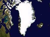
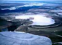
At the right is a satellite composite image of the ice sheet over Greenland.
Radiation astronomy
"Energetic photons, ions and electrons from the solar wind, together with galactic and extragalactic cosmic rays, constantly bombard surfaces of planets, planetary satellites, dust particles, comets and asteroids."[1] "[I]nterplanetary space ... is a stormy and sometimes very violent environment permeated by energetic particles and radiation constantly emanating from the Sun."[1]
Planets
Def. "a celestial body that
(a) is in orbit around the Sun,
(b) has sufficient mass for its self-gravity to overcome rigid body forces so that it assumes a hydrostatic equilibrium (nearly round) shape, and
(c) has cleared the neighbourhood around its orbit" is called a planet.[2]
The proposed more general definition for a planet in orbit around another star substitutes "a star" for "the Sun" in part (a), keeps part (b), does not contain part (c), and adds "is neither a star nor a satellite of a planet."[3]
Theoretical Earth
Def. the "third planet in order from the Sun, upon which humans live"[4] is called Earth.
Geognosy
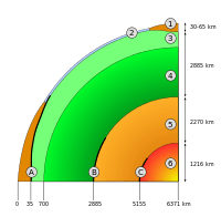
The diagram on the right is a theoretical interior for the Earth. Some of the depths and likely constitution of successive spheres are based on the results of geoseismology
"Evidence from seismology, heat flow at the surface, and mineral physics is combined with the Earth's mass and moment of inertia to infer models of the Earth's interior - its composition, density, temperature, pressure. For example, the Earth's mean specific gravity (5.515) is far higher than the typical specific gravity of rocks at the surface (2.7–3.3), implying that the deeper material is denser. This is also implied by its low moment of inertia (0.33 M R2, compared to 0.4 M R2 for a sphere of constant density). However, some of the density increase is compression under the enormous pressures inside the Earth. The effect of pressure can be calculated using the Adams–Williamson equation. The conclusion is that pressure alone cannot account for the increase in density."[5]
"Reconstruction of seismic reflections in the deep interior indicate some major discontinuities in seismic velocities that demarcate the major zones of the Earth: inner core, outer core, mantle, lithosphere and crust."[5]
"The seismic model of the Earth does not by itself determine the composition of the layers. For a complete model of the Earth, mineral physics is needed to interpret seismic velocities in terms of composition. The mineral properties are temperature-dependent, so the geotherm must also be determined. This requires physical theory for thermal conduction and convection and the heat contribution of [radionuclides] radioactive elements. The main model for the radial structure of the interior of the Earth is the Preliminary Reference Earth Model (PREM). Some parts of this model have been updated by recent findings in mineral physics (see post-perovskite) and supplemented by seismic tomography."[5]
Crusts
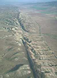
Using airborne astronomy, the image on the right shows a portion of the San Andreas Fault in California USA.
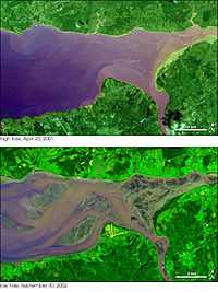
Cryospheres
"The cryosphere ... is [a] term which collectively describes the portions of [an astronomical object's] surface where water is in solid form, including sea ice, lake ice, river ice, snow cover, glaciers, ice caps and ice sheets, and frozen ground (which includes permafrost). Thus there [may be] a wide overlap with [a] hydrosphere. The cryosphere is an integral part of the global climate system with important linkages and feedbacks generated through its influence on surface energy and moisture fluxes, clouds, precipitation, hydrology, atmospheric and oceanic circulation. Through these feedback processes, the cryosphere plays a significant role in global climate and in [any] climate model response to global change."[6]
Lithospheres
"Between the crust and the mantle is the Mohorovičić discontinuity.[7]"[5]
Mantles
"The mantle is mainly composed of silicates, and the boundaries between layers of the mantle are consistent with phase transitions.[8]"[5]
"The mantle acts as a solid for seismic waves, but under high pressures and temperatures it deforms so that over millions of years it acts like a liquid. This makes plate tectonics possible. Geodynamics is the study of the fluid flow in the mantle and core."[5]
"The mantle itself is divided into the upper mantle, transition zone, lower mantle and D′′ layer."[5]
Outer cores
"Reconstructions of seismic waves in the deep interior of the Earth show that there are no S-waves in the outer core. This indicates that the outer core is liquid, because liquids cannot support shear. The outer core is liquid, and the motion of this highly conductive fluid generates the Earth's field (see geodynamo)."[5]
Inner cores
"[W]e know that the Earth's core is composed of an alloy of iron and other minerals.[8]"[5]
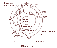
"A PKJKP [P wave, traversing the outer core K, and the inner core J, to emerge again as the P wave] traverses the inner core as a shear wave, so this is the direct evidence that the inner core is solid, because only in the solid material the shear wave can exist. In the liquid material, say water, only the compressional wave can travel through."[9]
Studying "archived data from about 20 large earthquakes, all monitored by an array of German seismic detectors back in the 1980s and '90s" has "reliably detected" a PKJKP wave in 2005, demonstrating that the inner core is solid.[10]
"The inner core, however, is solid because of the enormous pressure.[7]"[5]
The inner core "is a solid ball of superhot iron and nickel alloy about 760 miles (1,220 kilometers) in diameter. ... the inner core is, at 10,800 degrees Fahrenheit (6,000 degrees Celsius), as hot as the surface of the sun."[11]
"We know the Earth's inner core is composed mostly of iron".[12]
"The metal [iron] was subjected to more than 200 billion pascals of pressure".[11]
"[M]aterial within Earth's inner core is apparently distributed in a lopsided way ... The weakness of iron might lead crystallites in the inner core to flow and line up a certain way".[11]
"[T]he speed at which the inner core spun apparently fluctuated over the course of approximately decades between 1961 and 2007."[11]
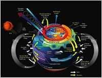
"As the inner core cools, crystallizing iron releases impurities, sending lighter molten material into the liquid outer core. This upwelling, combined with the Earth's rotation, drives convection, forcing the molten metal into whirling vortices. These vortices stretch and twist magnetic field lines, creating Earth’s magnetic field. Currently, the center of the field, called an axis, emerges in the Arctic Ocean west of Ellesmere Island, about 300 miles (500 kilometers) from the geographic North Pole."[13]
"In the last decade, seismic waves from earthquakes revealed the inner core looks like a navel orange, bulging slightly more on its western half. Geoscientists recently explained the asymmetry by proposing a convective loop: The inner core might be crystallizing on one half and melting on the other."[13]
"The lopsided growth of the inner core makes convection in the outer core a little bit lopsided, and that then induces the geomagnetic field to have this lopsided or eccentric character too".[14]
"Magnetic particles trapped and aligned in rocks reveal that the magnetic north pole wandered around the Western Hemisphere over the past 10,000 years, and circled the Eastern Hemisphere before that — a result mirrored by the numerical test."[13]
"The key question for interesting ideas like translational instability is, 'Can we test it?' ... What we're doing is proposing a test, and we think it's a good test because people can go out and look for eccentricity in the rock record and that will either confirm or shoot down this idea."[14]
"Within less than 100 million years, everything that has been crystallized on the west will have melted on the east"[15]
Seismic "waves appear to travel faster through the inner core from north to south than from west to east. Seismic properties also seemed to vary between the Eastern and Western hemispheres of the globe."[16]
There is a "124-mile (200-km) thick layer of dense material detected on its surface."[16]
"[T]he inner core [may be] shifted slightly off-center, just to the east. This would put more pressure on the western side, where it would be closer to the center of the planet, and less pressure on the eastern side. The result could be a perpetually denser Western hemisphere and a continual flow of dense fluid from the east that eventually spreads out atop the entire inner core."[16]
"The inner core is basically regenerating itself. And superimposed on that is this overall cooling that makes the inner core bigger and bigger over time".[17]
"It is the first observational evidence that the inner core rotates at a variety of speeds with respect to the mantle...It also reconciles old discrepancies".[18]
"The inner core, on average, rotates eastward. At the speeds it travels, it might, on average, complete a revolution every 750 to 1,440 years. However, these speeds appear unstable, which makes it uncertain just how long it actually takes to finish a turn on its axis".[11]
Meteors
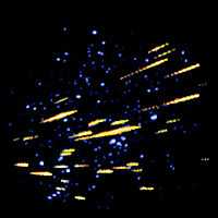
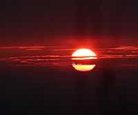
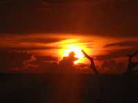
The Perseid meteor shower, a shower of rocks or rocky objects, usually the richest meteor shower of the year, peaks in August. Over the course of an hour, a person watching a clear sky from a dark location might see as many as 50-100 meteors. Most meteors are actually pieces of rock that have broken off a comet and continue to orbit the Sun. The Earth travels through the comet debris in its orbit. As the small pieces enter the Earth's atmosphere, friction can causes them to burn up.
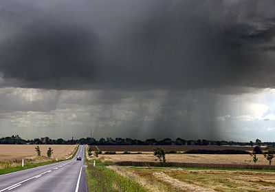
The lower two images on the right show slower moving objects or clouds. These move relative to objects on the ground. By theoretical definition these are also meteors, but composed of water droplets small enough to be suspended in the Earth's atmosphere. They can move horizontally or can rise or form vertically as water vapor (a gas) condenses into small liquid drops of water.
The image on the left shows two meteors, the clouds passing over land and the rain falling towards the ground from the clouds above as the water droplets either lose their static charge or reach too large a size to be held aloft either by the natural electric field of the Earth or by air currents, respectively. The water droplets are moving somewhat horizontally and also vertically.
Gamma rays
"[T]he Earth's atmosphere ... is a relatively bright source of gamma rays produced in interactions of ordinary cosmic ray protons with air atoms"[19].
X-rays
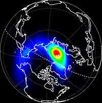
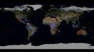
The Earth is a known astronomical object. It is usually not thought of as an X-ray source.
At left is a composite image which contains the first picture of the Earth in X-rays, taken in March, 1996, with the orbiting Polar satellite. The area of brightest X-ray emission is red.
Energetic charged particles from the Sun energize electrons in the Earth's magnetosphere. These electrons move along the Earth's magnetic field and eventually strike the ionosphere, causing the X-ray emission.
Opticals
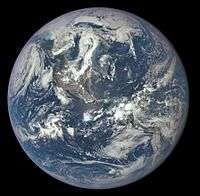
"A NASA camera on the Deep Space Climate Observatory (DSCOVR) satellite has returned its first view of the entire sunlit side of Earth [on the right] from one million miles away."[20]
"The color images of Earth from NASA’s Earth Polychromatic Imaging Camera (EPIC) are generated by combining three separate images to create a photographic-quality image. The camera takes a series of 10 images using different narrowband filters -- from ultraviolet to near infrared -- to produce a variety of science products. The red, green and blue channel images are used in these Earth images."[20]
"This first DSCOVR image of our planet demonstrates the unique and important benefits of Earth observation from space. As a former astronaut who’s been privileged to view the Earth from orbit, I want everyone to be able to see and appreciate our planet as an integrated, interacting system. DSCOVR’s observations of Earth, as well as its measurements and early warnings of space weather events caused by the sun, will help every person to monitor the ever-changing Earth, and to understand how our planet fits into its neighborhood in the solar system.”[21]
"These initial Earth images show the effects of sunlight scattered by air molecules, giving the images a characteristic bluish tint."[20]
"The images clearly show desert sand structures, river systems and complex cloud patterns."[22]
"The primary objective of DSCOVR, a partnership between NASA, the National Oceanic and Atmospheric Administration (NOAA) and the U.S. Air Force, is to maintain the nation’s real-time solar wind monitoring capabilities, which are critical to the accuracy and lead time of space weather alerts and forecasts from NOAA."[20]
"In addition to space weather instruments, DSCOVR carries a second NASA sensor -- the National Institute of Science and Technology Advanced Radiometer (NISTAR)."[20]
NASA's Earth Polychromatic Imaging Camera (EPIC) "is a four megapixel CCD camera and telescope. The color Earth images are created by combining three separate single-color images to create a photographic-quality imageequivalent to a 12-megapixel camera. The camera takes a series of 10 images using different narrowband filters -- from ultraviolet to near infrared -- to produce a variety of science products. The red, green and blue channel images are used to create the color images. Each image is about 3 megabytes in size."[20]
"The effective resolution of the DSCOVR EPIC camera is somewhere between 6.2 and 9.4 miles (10 and 15 kilometers)."[22]
Visuals
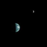
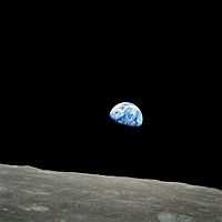

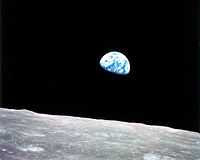
For those observers looking toward the Earth from another location such as near the Moon in the photograph at above right, it seems that the Earth is a natural object. On the Earth 384,000 km away, the sunset terminator bisects Africa.
A closer view of Earth shows some of the astronomical objects near the Earth and apparently just above the surface, where an observer may be. Some of these objects such as clouds probably by convention are more likely to be studied by planetary observers, or weather observers, rather than astronomical observers.
With perspectives other than upwards from the Earth's crustal surface, the word "sky" may seem insufficient or inappropriate, although studying the Earth as part of planetary science may leave interesting astronomical objects near the Earth that are occasionally "in the sky". The idea being that the Earth cannot be in its own sky, or can it? Perhaps, it is more a matter of whether other observers agree that what an observer is observing is astronomy or planetary science, or both.
"The search for life on extrasolar planets" requires a test of vegetation detectability from a single dot source.[23]
"The earthshine, or ashen light, is the glow of the dark part of the lunar disk visible to a night-time observer. ... [T]he light rays coming from different parts of the Earth are mixed together in the ashen light and mimic the Earth as a single dot."[23]
"[T]he vegetation spectrum which is unequivocal ... presents a bump at 0.5 µ in the green wavelength range, which implies that plants appear green".[23]
Skys

Being outside in the day light to look upward when the Sun is off to the East or West, you may see that the sky is blue depending on the weather.
There are many other natural objects, entities, bodies, or phenomena that occur in the sky. Some of these may occur frequently: the Sun passes overhead every day, so does the Moon either during the day or at night, a variety of clouds pass across the sky and sometimes completely fill the sky for days, occasionally a few go in the opposite direction across the sky or in different directions.
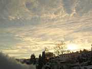
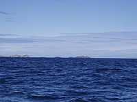
Def. "the expanse of space that seems to be over the earth like a dome"[24] is called the sky, or the sometimes the heavens.
This definition applies especially well to an individual on top of the Earth's solid crust looking around at what lies above and off to the horizon in all directions. Similarly, it applies to an individual's visual view while floating on a large body of water, where off on the horizon is still water.
The image at right shows the horizon marking the lower edge of the sky and the upper edge of the Atlantic Ocean, with a layer of cumulus clouds just above.
Def. an "expanse of space that seems to be [overhead] like a dome"[24] is called a sky.
Even in day light, the sky may seem absent of objects if a nearby source tends to overwhelm other luminous objects.
Volcanoes
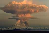
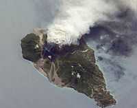
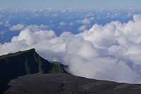
Oblique images such as the one at right are taken by astronauts looking out from the ISS at an angle, rather than looking straight downward toward the Earth (a perspective called a nadir view), as is common with most remotely sensed data from satellites. An oblique view gives the scene a more three-dimension quality, and provides a look at the vertical structure of the volcanic plume. While much of the island is covered in green vegetation, grey deposits that include pyroclastic flows and volcanic mud-flows (lahars) are visible extending from the volcano toward the coastline. When compared to its extent in earlier views, the volcanic debris has filled in more of the eastern coastline. Urban areas are visible in the northern and western portions of the island; they are recognizable by linear street patterns and the presence of bright building rooftops. The silver-grey appearance of the Caribbean Sea surface is due to sun-glint, which is the mirror-like reflection of sunlight off the water surface back towards the hand-held camera on-board the ISS. The sun-glint highlights surface wave patterns around the island.
Craters
Occasionally, objects fall from the sky. When and where this occurs, depending on the energy dumped into the atmosphere and the impact on the crust of the Earth, life forms nearby hear it, feel the vibrations from it, and recoil if the intensity is too high.
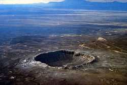
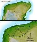
But asteroid impacts, though rare, occur once in a while, over very large areas, at aperiodic intervals such as the Chicxulub crater. Most scientists agree that this impact is the cause of the Cretatious-Tertiary Extinction, 65 million years ago (Ma), that marked the sudden extinction of the dinosaurs and the majority of life then on Earth. This shaded relief image of Mexico's Yucatan Peninsula shows a subtle, but unmistakable, indication of the Chicxulub impact crater.
Tides


In addition to the Sun, the Moon affects life forms on Earth such as those along the shores of bodies of water through the production of tides.
"Due to phenomena such as ice ages, plate tectonics, land uplift, erosion and sedimentation, tides have changed dramatically over thousands of years"[26].
"Some tides on the East Coast of the United States ... may ... have [had] ... a difference between low and high tide of 10-20 feet, instead of the current 3-6 foot range."[26]
"The Guinness Book of World Records (1975) declared that Burntcoat Head, Nova Scotia has the highest tides in the world:"[27]
“The greatest tides in the world occur in the Bay of Fundy.... Burntcoat Head in the Minas Basin, Nova Scotia, has the greatest mean spring range with 14.5 metres (47.5 feet) and an extreme range of 16.3 metres (53.5 feet).”
But they "didn’t amount to much at all about 5,000 years ago. ... [A]round that same time, tides on the southern U.S. Atlantic coast, from North Carolina to Florida, were about 75 percent higher."[26]
"[A]round 9,000 years ago ... there was a huge amplification in tides of the western Atlantic Ocean. The tidal ranges were up to three times more extreme than those that exist today, and water would have surged up and down on the East Coast."[26]
Today Hudson Bay is a place "where tidal energy gets dissipated at a disproportionately high rate ... But during the last ice age Hudson Bay was closed down and buried in ice, and that caused more extreme tides elsewhere."[26]
Auroras
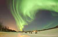
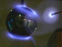
Computer simulations are usually used to represent auroras. The image at right shows a terrella in a laboratory experiment to produce auroras.
"Although auroras might first appear to be moonlit clouds, they only add light to the sky and do not block background stars from view. Called "Northern Lights" in the Northern Hemisphere, auroras are caused by collisions between charged particles from the magnetosphere and air molecules high in the Earth's atmosphere. If viewed from space, auroras can be seen to glow in X-ray and ultraviolet light as well. Predictable auroras might occur a few days after a powerful magnetic event has been seen on the sun."[28]
"Most aurorae occur in a band known as the auroral zone,[29][30] which is typically 3° to 6° in latitudinal extent and at all local times or longitudes. The auroral zone is typically 10° to 20° from the magnetic pole defined by the axis of the Earth's magnetic dipole. During a geomagnetic storm, the auroral zone will expand to lower latitudes. The diffuse aurora is a featureless glow in the sky which may not be visible to the naked eye even on a dark night and defines the extent of the auroral zone. The discrete aurora are sharply defined features within the diffuse aurora which vary in brightness from just barely visible to the naked eye to bright enough to read a newspaper at night. Discrete aurorae are usually observed only in the night sky because they are as bright as the sunlit sky. Aurorae occasionally occur poleward of the auroral zone as diffuse patches[31] or arcs (polar cap arcs[32]), which are generally invisible to the naked eye."[33]
Natural electric fields
On Earth, between the surface and various altitudes there is an electric field. It changes with altitude from about 150 volts per meter to lower values at higher altitude. In fair weather, it is relatively constant, in turbulent weather it is accompanied by ions. At greater altitude these chemical species continue to increase in concentration.
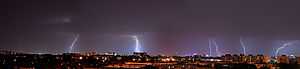
Usually when clouds fill the sky and associated with some of these clouds is lightning, a phenomenon that moves so quickly it’s difficult to think of it as an object or entity with a body.
"A number of observations by space-based telescopes have revealed ... gamma ray emissions ... terrestrial gamma-ray flashes (TGFs). These observations pose a challenge to current theories of lightning, especially with the discovery of the clear signatures of antimatter produced in lightning.[34]"[35]
"[A] TGF [has been linked] to an individual lightning stroke occurring within 1.5 ms of the TGF event,[36] proving for the first time that the TGF was of atmospheric origin and associated with lightning strikes"[35]
The "Reuven Ramaty High Energy Solar Spectroscopic Imager (RHESSI) spacecraft, as reported by David Smith of UC Santa Cruz, has been observing TGFs at a much higher rate, indicating that these occur about 50 times per day globally (still a very small fraction of the total lightning on the planet). The energy levels recorded exceed 20 MeV. ... [Apparently, the] gamma radiation fountains upward from starting points at surprisingly low altitudes in thunderclouds. ... Steven Cummer, from Duke University's Pratt School of Engineering, said, "These are higher energy gamma rays than come from the sun. And yet here they are coming from the kind of terrestrial thunderstorm that we see here all the time." ... In 2009, [the] Fermi Gamma Ray Telescope in Earth orbit observed [an] intense burst of gamma rays corresponding to positron annihilations coming out of a storm formation. Scientists wouldn't have been surprised to see a few positrons accompanying any intense gamma ray burst, but the lightning flash detected by Fermi appeared to have produced about 100 trillion positrons. This has been reported by media in January 2011, it is an effect, never considered to happen before.[37]"[35]
Zodiacal Light
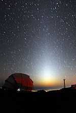
"According to Gruson and Brugsch the Egyptians were acquainted with, and even worshipped, the zodiacal light from the very earliest times, as a phenomenon visible throughout the East before sunrise and after sunset. It was described as a glowing sheaf or luminous pyramid perpendicular to the horizon in summer, and inclined more or less during the winter. Indeed the Egyptians represented the zodiacal light under the form of a triangle which sometimes stood upright and at other times was inclined."[38]
Blues
Def. "[t]he gases surrounding the Earth or any astronomical body"[39] is called an atmosphere.
“Atmospheric gases scatter blue light more than other wavelengths, giving the Earth a blue halo when seen from space.”[40], as shown in the image at right.
Rocky objects
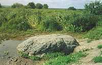
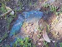
"Sin-Kamen (Синь-Камень, in Russian literally – Blue Stone, or Blue Rock) is a type of pagan sacred stones, widespread in Russia, in areas historically inhabited by both Eastern Slavic (Russian), and Uralic tribes (Merya, Muroma[41])."[42]
"While in the majority of cases, the stones belonging to the Blue Stones type, have a black, or dark gray color, this particular stone [in the image] does indeed look dark blue, when wet.[43]"[42]
Meteorites
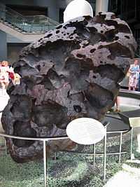
Def. "[a] metallic or stony object that is the remains of a meteor", from Wiktionary meteorite, is called a meteorite.
Many of the meteorites that are found on Earth turn out to be from other solar system objects: the Moon and Mars, for example.
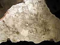
"Widmanstätten patterns, also called Thomson structures, are unique figures of long nickel-iron crystals, found in the octahedrite iron meteorites and some pallasites. They consist of a fine interleaving of kamacite and taenite bands or ribbons called lamellæ. Commonly, in gaps between the lamellæ, a fine-grained mixture of kamacite and taenite called plessite can be found."[44]
Micrometeorites
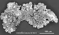
Micrometeorite is often abbreviated as MM. Most MMs are broadly chondritic in composition, meaning "that major elemental abundance ratios are within about 50% of those observed in carbonaceous chondrites."[45] Some MMs are chondrites, (basaltic) howardite, eucrite, and diogenite (HED) meteorites or Martian basalts, but not lunar samples.[45] "[T]he comparative mechanical weakness of carbonaceous precursor materials tends to encourage spherule formation."[45] From the number of different asteroidal precursors, the approximate fraction in MMs is 70 % carbonaceous.[45] "[T]he carbonaceous material [is] known from observation to dominate the terrestrial MM flux."[45] The "H, L, and E chondritic compositions" are "dominant among meteorites but rare among micrometeorites."[45]
"Ureilites occur about half as often as eucrites (Krot et al. 2003), are relatively friable, have less a wide range of cosmic-ray exposure ages including two less than 1 Myr, and, like the dominant group of MM precursors, contain carbon."[45]
Atmospheric astronomy
These molecules in many instances are in turn made up of atoms of chemical elements. At your geographical location, specified in latitude and longitude, this gaseous envelope extends upward. The atmosphere of Earth changes with altitude. At high enough altitude the composition changes significantly, as does the temperature and pressure.
The Earth's atmosphere is divided into altitude regions:[46]
- Troposphere — surface to 8,000 m at the poles – 18,000 m at the equator, ending at the Tropopause.
- Stratosphere — Troposphere to 50 km
- Mesosphere — Stratosphere to 85 km
- Thermosphere — Mesosphere to 675 km
- Exosphere — Thermosphere to 10,000 km, after altitude regions.
Ionospheres
Upon reaching the top of the mesosphere, the temperature starts to rise, but air pressure continues to fall. This is the beginning of the ionosphere, a region dominated by chemical ions. Many of them are the same chemicals such as nitrogen and oxygen in the atmosphere below, but an ever increasing number are hydrogen ions (protons) and helium ions. These can be detected by an ion spectrometer. The process of ionization removes one or more electrons from a neutral atom to yield a variety of ions depending on the chemical element species and incidence of sufficient energy to remove the electrons.
Exospheres
Into the exosphere or outer space, temperature rises from around 1,500°C to upwards of 100,000 K.
Sun
The Sun passes overhead every day on Earth. The size of its disc is very close to that of the Moon.
"Regarding the fixed stars, the Sun appears from Earth to revolve once a year along the ecliptic through the zodiac, and so Greek astronomers considered it to be one of the seven planets (Greek planetes, "wanderer"), after which the seven days of the week are named in some languages.[47][48][49]"[50]
"And Helios, lord of the sun, sitting Away from the other gods, sitting in his own temple And listening to prayers breathing up from men: he heard."[51]
"[A]stronomically, the visible Helios occupies the central position among the seven planets - Kronos, Zeus, Ares, Helios, Aphrodite, Hermes, and Selene, in a descending series."[52]
Tephra layers
An ashfall occurs from a nearby volcano, before the locals can leave the area or maybe even go to work.
Aircraft

The "Stratospheric Observatory for Infrared Astronomy [(SOFIA) is] mounted onboard a Boeing 747SP. [...] SOFIA’s 2.7 m mirror and optimized telescope system combines the highest available spatial resolution with excellent sensitivity. SOFIA will operate in both celestial hemispheres for the next two decades."[53]
It has an operating altitude of 12-14 km, 39,000-45,000 ft and a spatial resolution of 1-3" for 0.3 < λ < 15 µm, and λ/10" for λ > 15 µm.[53]
Research
Hypothesis:
- Earth is a rocky object throughout most of its interior and exterior.
Control groups

The findings demonstrate a statistically systematic change from the status quo or the control group.
“In the design of experiments, treatments [or special properties or characteristics] are applied to [or observed in] experimental units in the treatment group(s).[54] In comparative experiments, members of the complementary group, the control group, receive either no treatment or a standard treatment.[55]"[56]
Proof of concept
Def. a “short and/or incomplete realization of a certain method or idea to demonstrate its feasibility"[57] is called a proof of concept.
Def. evidence that demonstrates that a concept is possible is called proof of concept.
The proof-of-concept structure consists of
- background,
- procedures,
- findings, and
- interpretation.[58]
See also
References
- 1 2 Theodore E. Madey, Robert E. Johnson, Thom M. Orlando (March 2002). "Far-out surface science: radiation-induced surface processes in the solar system". Surface Science 500 (1-3): 838-58. doi:10.1016/S0039-6028(01)01556-4. http://www.physics.rutgers.edu/~madey/Publications/Full_Publications/PDF/madey_SS_2002.pdf. Retrieved 2012-02-09.
- ↑ Lars Lindberg Christensen (August 24, 2006). "IAU 2006 General Assembly: Result of the IAU Resolution votes". International Astronomical Union. Retrieved 2011-10-30.
- ↑ Lars Lindberg Christensen (August 16, 2006). "The IAU draft definition of "planet" and "plutons"". International Astronomical Union. Retrieved 2011-10-30.
- ↑ 24.77.96.119 (11 November 2005). "Earth, In: Wiktionary". San Francisco, California: Wikimedia Foundation, Inc. Retrieved 2016-02-06.
- 1 2 3 4 5 6 7 8 9 10 "Geophysics, In: Wikipedia". San Francisco, California: Wikimedia Foundation, Inc. October 18, 2012. Retrieved 2012-11-16.
- ↑ "Cryosphere, In: Wikipedia". San Francisco, California: Wikimedia Foundation, Inc. June 15, 2013. Retrieved 2013-06-23.
- 1 2 Lowrie, William (2004). Fundamentals of Geophysics. Cambridge University Press. ISBN 0-521-46164-2.
- 1 2 Jean-Paul Poirier (2000). Introduction to the Physics of the Earth's Interior. Cambridge Topics in Mineral Physics & Chemistry. Cambridge University Press. ISBN 0-521-66313-X.
- ↑ Aimin Cao (April 14, 2005). "Finally, a Solid Look at Earth's Core". Live Science. Retrieved 2013-05-14.
- ↑ Robert Roy Britt (April 14, 2005). "Finally, a Solid Look at Earth's Core". Live Science. Retrieved 2013-05-14.
- 1 2 3 4 5 Charles Q. Choi (May 13, 2013). "Earth's Rotating Inner Core Shifts Its Speed". Yahoo! News. Retrieved 2013-05-14.
- ↑ Arianna Gleason (May 13, 2013). "Earth's Rotating Inner Core Shifts Its Speed". Yahoo! News. Retrieved 2013-05-14.
- 1 2 3 Becky Oskin (July 18, 2012). "Why Earth's Magnetic Field Is Wonky". LiveScience. Retrieved 2013-05-14.
- 1 2 Peter Olson (July 18, 2012). "Why Earth's Magnetic Field Is Wonky". LiveScience. Retrieved 2013-05-14.
- ↑ Thierry Alboussiere (August 4, 2010). "Earth's Inner Core Might Be on the Move". Live Science. Retrieved 2013-05-14.
- 1 2 3 Lynne Peeples (August 4, 2010). "Earth's Inner Core Might Be on the Move". Live Science. Retrieved 2013-05-14.
- ↑ Michael Bergman (August 4, 2010). "Earth's Inner Core Might Be on the Move". Live Science. Retrieved 2013-05-14.
- ↑ Hrvoje Tkalcic (May 13, 2013). "Earth's Rotating Inner Core Shifts Its Speed". Yahoo! News. Retrieved 2013-05-14.
- ↑ "Explorer 11, In: Wikipedia". San Francisco, California: Wikimedia Foundation, Inc. 15 February 2014. Retrieved 2014-02-15.
- 1 2 3 4 5 6 Steve Cole and Rob Gutro (20 July 2015). "NASA Satellite Camera Provides “EPIC” View of Earth". Washington, DC USA: NASA. Retrieved 2015-12-09.
- ↑ Charlie Bolden (20 July 2015). "NASA Satellite Camera Provides “EPIC” View of Earth". Washington, DC USA: NASA. Retrieved 2015-12-09.
- 1 2 Adam Szabo (20 July 2015). "NASA Satellite Camera Provides “EPIC” View of Earth". Washington, DC USA: NASA. Retrieved 2015-12-09.
- 1 2 3 Danielle Briot, Jean Schneider, and Luc arnold (October 2003). M. Fridlund, T. Henning. ed. The terrestrial vegetation observed in the Earthshine spectrum: a test for the detectability of vegetation on extrasolar planets, In: Proceedings of the Conference on Towards Other Earths: DARWIN/TPF and the Search for Extrasolar Terrestrial Planets. Noordwijk, Netherlands: European Space agency. pp. 375-8. ISBN 92-9092-849-2. Bibcode: 2003ESASP.539..375B.
- 1 2 Philip B. Gove, ed (1963). Webster's Seventh New Collegiate Dictionary. Springfield, Massachusetts: G. & C. Merriam Company. pp. 1221.
- ↑ Warren Wiscombe (June 14, 2006). "High and Low Tides in Bay of Fundy". NASA Goddard Space Flight Center: NASA Earth Observatory. Retrieved 2012-05-27.
- 1 2 3 4 5 David Hill (July 29, 2011). "Ancient Tides Different from Today - Some Dramatically Higher". Corvallis, Oregon: Oregon State University. Retrieved 2012-05-27.
- ↑ "Bay of Fundy, In: Wikipedia". San Francisco, California: Wikimedia Foundation, Inc. May 10, 2012. Retrieved 2012-05-27.
- ↑ Samantha Harvey (September 28, 2011). "Aurora Over Norway". NASA. Retrieved 2012-07-21.
- ↑ Feldstein, Y. I. (1963). "Some problems concerning the morphology of auroras and magnetic disturbances at high latitudes". Geomagnetism and Aeronomy 3: 183–192.
- ↑ Feldstein, Y. I. (1986). "A Quarter Century with the Auroral Oval". EOS 67 (40): 761. doi:10.1029/EO067i040p00761-02.
- ↑ E. J. Weber et al. (1984). "F layer ionization patches in the polar cap". J. Geophys. Res. 89 (A3): 1683–94. doi:10.1029/JA089iA03p01683.
- ↑ Frank, L. A. et al. (1986). "The theta aurora". J. Geophys. Res. 91 (A3): 3177–3224. doi:10.1029/JA091iA03p03177.
- ↑ "Aurora (astronomy), In: Wikipedia". San Francisco, California: Wikimedia Foundation, Inc. July 14, 2012. Retrieved 2012-07-21.
- ↑ Signature Of Antimatter Detected In Lightning - Science News
- 1 2 3 "Lightning, In: Wikipedia". San Francisco, California: Wikimedia Foundation, Inc. 15 February 2014. Retrieved 2014-02-15.
- ↑ U.S. Inan, S.C. Reising, G.J. Fishman, and J.M. Horack. On the association of terrestrial gamma-ray bursts with lightning and implications for sprites. Geophysical Research Letters, 23(9):1017-20, May 1996. As quoted by elf.gi.alaska.edu Retrieved 2007-03-06.
- ↑ http://news.nationalgeographic.com/news/2011/01/110111-thunderstorms-antimatter-beams-fermi-radiation-science-space/
- ↑ M. E. Lefébure (November 1900). "The Zodiacal Light according to the Ancients". The Observatory, A Monthly Review of Astronomy 23 (298): 393-8. http://adsabs.harvard.edu/cgi-bin/nph-data_query?bibcode=1900Obs....23..393.&link_type=ARTICLE&db_key=AST&high=. Retrieved 2011-11-08.
- ↑ 212.159.113.112 (6 May 2003). "atmosphere, In: Wiktionary". San Francisco, California: Wikimedia Foundation, Inc. Retrieved 2016-02-06.
- ↑ "Atmosphere, In: Wikipedia". San Francisco, California: Wikimedia Foundation, Inc. 15 february 2014. Retrieved 2014-02-15.
- ↑ И.Д. Маланин. Материалы разведки Синих камней Подмосковья в 2003 году // Краеведение и регионоведение. Межвузовский сборник научных трудов. ч.1. Владимир, 2004. (Russian)
- 1 2 "Blue Stone (Russia), In: Wikipedia". San Francisco, California: Wikimedia Foundation, Inc. March 20, 2013. Retrieved 2013-05-31.
- ↑ Бердников, В. Синий камень Плещеева озера // Наука и жизнь. – 1985. – № 1. – С. 134–139. (Russian)
- ↑ "Widmanstätten pattern, In: Wikipedia". San Francisco, California: Wikimedia Foundation, Inc. 15 February 2014. Retrieved 2014-02-15.
- 1 2 3 4 5 6 7 Susan Taylor, Gregory F. Herzog, Gregory, Jeremy S. Delaney, (2007). "Crumbs from the crust of Vesta: Achondritic cosmic spherules from the South Pole water well". Meteoritics & Planetary Science 42 (2): 223-33. doi:10.1111/j.1945-5100.2007.tb00229.x.
- ↑ "Layers of the Atmosphere". JetStream, the National Weather Service Online Weather School. National Weather Service. Retrieved 22 December 2005.
- ↑ "planet, n.". Oxford English Dictionary. December 2007. Retrieved 2008-02-07. Note: select the Etymology tab
- ↑ Bernard R. Goldstein (1997). "Saving the phenomena : the background to Ptolemy's planetary theory". Journal for the History of Astronomy (Cambridge (UK)) 28 (1): 1–12.
- ↑ Ptolemy; Toomer, G. J. (1998). Ptolemy's Almagest. Princeton University Press. ISBN 9780691002606.
- ↑ "Sun, In: Wikipedia". San Francisco, California: Wikimedia Foundation, Inc. 15 February 2014. Retrieved 2014-02-15.
- ↑ Burton Raffel (Winter 1970). "Homeric Hymn to Demeter 1-89". Arion 9 (4): 415-20. doi:10.2307/20163307. http://www.jstor.org/stable/10.2307/20163307. Retrieved 2012-04-24.
- ↑ Roger Pack (1946). "Notes on the Caesars of Julian". Transactions and Proceedings of the American Philological Association 77: 151-7. http://www.jstor.org/stable/10.2307/283452. Retrieved 2012-04-24.
- 1 2 Alfred Krabbe (March, 2007). SOFIA telescope, In: ‘’Proceedings of SPIE: Astronomical Telescopes and Instrumentation’’. Munich, Germany: SPIE — The International Society for Optical Engineering. pp. 276–281. http://arxiv.org/pdf/astro-ph/0004253v1.pdf.
- ↑ Klaus Hinkelmann, Oscar Kempthorne (2008). Design and Analysis of Experiments, Volume I: Introduction to Experimental Design (2nd ed.). Wiley. ISBN 978-0-471-72756-9. http://books.google.com/?id=T3wWj2kVYZgC&printsec=frontcover.
- ↑ R. A. Bailey (2008). Design of comparative experiments. Cambridge University Press. ISBN 978-0-521-68357-9. http://www.cambridge.org/uk/catalogue/catalogue.asp?isbn=9780521683579.
- ↑ "Treatment and control groups, In: Wikipedia". San Francisco, California: Wikimedia Foundation, Inc. May 18, 2012. Retrieved 2012-05-31.
- ↑ "proof of concept, In: Wiktionary". San Francisco, California: Wikimedia Foundation, Inc. November 10, 2012. Retrieved 2013-01-13.
- ↑ Ginger Lehrman and Ian B Hogue, Sarah Palmer, Cheryl Jennings, Celsa A Spina, Ann Wiegand, Alan L Landay, Robert W Coombs, Douglas D Richman, John W Mellors, John M Coffin, Ronald J Bosch, David M Margolis (August 13, 2005). "Depletion of latent HIV-1 infection in vivo: a proof-of-concept study". Lancet 366 (9485): 549-55. doi:10.1016/S0140-6736(05)67098-5. http://www.sciencedirect.com/science/article/pii/S0140673605670985. Retrieved 2012-05-09.
External links
![]() This is a research project at http://en.wikiversity.org
This is a research project at http://en.wikiversity.org
| |
Development status: this resource is experimental in nature. |
| |
Educational level: this is a research resource. |
| |
Resource type: this resource is an article. |
| |
Resource type: this resource contains a lecture or lecture notes. |
| |
Subject classification: this is an astronomy resource. |