Callisto
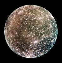
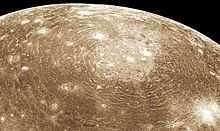
At right is a complete global color image of Callisto.
Astronomy
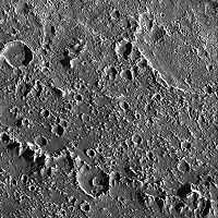
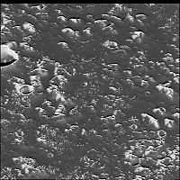
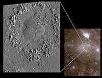
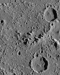
"This fascinating region [in the image at the right] of Jupiter's icy moon, Callisto, shows the transition from the inner part of an enormous impact basin, Asgard, to the outer "surrounding plains." Small, bright, fine textured, closely spaced bumps appear throughout the inner part of the basin (top of image) and create a more fine textured appearance than that seen on many of the other inter-crater plains on Callisto. At low resolution, these icy bumps make Asgard's center brighter than the surrounding terrain. What caused the bumps to form is still unknown, but they are associated clearly with the impact that formed Asgard."[1]
"The ridge that cuts diagonally across the lower left corner is one of many giant concentric rings that extend for hundreds of kilometers outside Asgard's center. Exterior to the ring (lower left corner), Callisto's surface changes significantly. Still peppered with craters, the number of icy bumps decreases while their average size increases. The fine texture is not as visible in the middle of the image. One explanation is that material from raised features (such as the ridge) may slide down slope and cover small scale features. Such images of Callisto help us understand the dynamics of giant impacts into icy surfaces, and how the large structures change with time."[1]
"North is to the top of the picture. The image, centered at 27.1 degrees north latitude and 142.3 degrees west longitude, covers an area approximately 80 kilometers (50 miles) by 90 kilometers (55 miles). The resolution is about 90 meters (295 feet) per picture element. The image was taken on September 17th, 1997 at a range of 9200 kilometers (5700 miles) by the Solid State Imaging (SSI) system on NASA's Galileo spacecraft during its tenth orbit of Jupiter."[1]
Planetary science
Bright scars on a darker surface testify to a long history of impacts on Jupiter's moon Callisto. The picture, taken in May 2001, is the only complete global color image of Callisto obtained by Galileo, which has been orbiting Jupiter since December 1995. Of Jupiter's four largest moons, Callisto orbits farthest from the giant planet. Callisto's surface is uniformly cratered but is not uniform in color or brightness. Scientists believe the brighter areas are mainly ice and the darker areas are highly eroded, ice-poor material.
"Callisto rotates synchronously with its orbital period, so the same hemisphere always faces (is tidally locked to) Jupiter. Callisto's surface is less affected by Jupiter's magnetosphere than the other inner satellites because it orbits farther away.[2]"[3]
Colors
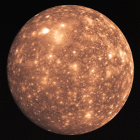

In the Voyager 2 image at the right, the structure Asgard is seen near the top towards the left.
The image at the left has been color adjusted from the image at the right and rotated to put north at the top. Both images are the same by Voyager 2.
Minerals
"Compounds detected spectroscopically on the surface include water ice, carbon dioxide, silicates, and organic compounds."[3]
Theoretical Callisto
It is generally believed that large astronomical objects like Callisto are spheroidal to spherical due to hydrodynamic stability. Another possibility is that relatively random collisions with the initial seed object all around it eventually lead to a spherical or spheroidal object as more material collides and sticks to the seed object. Callisto may be the best example of this growth process.
Entities
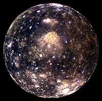

The image of Callisto by the Galileo spacecraft at the right is rotated to the other side from the color and albedo adjusted image from Voyager 2 on the left above, about 90°. The bright area above the center of the image is crater complex called Valhalla. Valhalla is approximately at 16°N latitude and 55°W longitude. Asgard is located at about 27°N latitude and 142°W longitude.
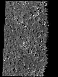
"A portion of the central zone of the large impact structure Valhalla [image at the left] on Jupiter's moon Callisto was imaged by the Galileo spacecraft on November 4, 1996. The area shown here is centered at 16 degrees north, 55 degrees west and is about seven miles (11 kilometers) across. This is the highest resolution picture ever taken of Callisto and shows features as small as 200 feet (60 meters) across. The formation of Valhalla occurred early in Callisto's history; however, the central zone shown here is probably younger than Valhalla's surrounding structure. This newly acquired picture shows some small craters, although they have been softened or modified by downslope movement of debris, revealing bright ice-rich surfaces. In contrast to other areas on Callisto, most of the very smallest craters appear to have been completely obliterated."[4]
The image on the left "was taken by the solid state imaging television camera onboard the Galileo spacecraft during its third orbit around Jupiter, at a distance of 757 miles (1,219 kilometers)."[4]
"The New Horizons Long Range Reconnaissance Imager (LORRI) captured these two images of Jupiter's outermost large moon, Callisto, [at the lower right] as the spacecraft flew past Jupiter in late February 2007. New Horizons' closest approach distance to Jupiter was 2.3 million km (1.4 million miles), not far outside Callisto's orbit, which has a radius of 1.9 million km (1.2 million miles). However, Callisto happened to be on the opposite side of Jupiter during the spacecraft's pass through the Jupiter system, so these images, taken from 4.7 million and 4.2 million km (3.0 million and 2.6 million miles) away, are the closest obtained by New Horizons of Callisto."[5]
"Callisto's ancient, crater-scarred surface makes it very different from its three more active sibling satellites, Io, Europa and Ganymede. Callisto, 4,800 km (3000 miles) in diameter, displays no large-scale geological features other than impact craters, and every bright spot in these images is a crater. The largest impact feature on Callisto, the huge basin Valhalla, is visible as a bright patch at the 10 o'clock position. The craters are bright because they have excavated material relatively rich in water ice from beneath the dark, dusty material that coats most of the surface."[5]
"The two images show essentially the same side of Callisto -- the side that faces Jupiter -- under different illumination conditions. The images accompanied scans of Callisto's infrared spectrum with New Horizons' Linear Etalon Imaging Spectral Array (LEISA). The New Horizons science team designed these scans to study how the infrared spectrum of Callisto's water ice changes as lighting and viewing conditions change, and as the ice cools through Callisto's late afternoon. The infrared spectrum of water ice depends slightly on its temperature."[5]
"The left image, taken at 05:03 Universal Time on 27 February 2007, is centered at 5 degrees south, 5 degrees west, and has a solar phase angle of 46 degrees. The right image was taken at 03:25 Universal Time on 28 February 2007. It is centered at 4 degrees south, 356 degrees west and has a solar phase angle of 76 degrees."[5]
The third image on the left shows the concentric rings or troughs surrounding the Valhalla structure.
"The concentric rings surrounding Valhalla are perhaps the most distinctive geological feature on Callisto. This Voyager 1 close-up shows a segment of the ridged terrain. The presence of superimpact craters shows that the rings formed early in Callisto's history; however, the density of craters is less here than on other parts of the satellite, where the surface is older."[6]
At about the upper left, stretching linearly down the image is a catena of craters.
Objects
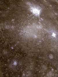
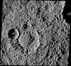
"Low-resolution color data were combined with a higher resolution mosaic to produce this infrared composite image of a pair of ancient multi-ringed impact basins on Jupiter's moon, Callisto. The region imaged is on the leading hemisphere of Callisto near 26 degrees north, 142 degrees west, and is almost 1,400 kilometers (860 miles) across. North is toward the top of the picture and the Sun illuminates the surface from the east. Dominating the scene is the impact structure, Asgard, centered on the smooth, bright region near the middle of the picture and surrounded by concentric rings up to 1,700 kilometers (about 1,050 miles) in diameter. A second ringed structure with a diameter of about 500 kilometers (310 miles) can be seen to the north of Asgard, partially obscured by the more recent, bright-rayed crater, Burr. The icy materials excavated by the younger craters contrast sharply with the darker and redder coatings on older surfaces of Callisto."[4]
The second image at the right shows the Asgard structure.
"This composite of Galileo spacecraft images of Jupiter's icy moon Callisto combines data from two orbits showing several types of impact craters. North is to the top of the picture; the Sun illuminates the surface from the east. The global image on the right shows one of the largest impact structures on Callisto, the Asgard multiring structure [...] consists of a bright central zone surrounded by discontinuous rings. The rings include degraded ridges near the central zone and troughs at the outer margin, which resulted from deformation of the icy crust following impact."[7]
"Smaller impacts have smashed into Callisto after the formation of Asgard. The young, bright-rayed crater Burr located on the northern part of Asgard is about 75 km across. Galileo images show a third type of impact crater in this image, a dome crater named Doh, located in the bright central plains of Asgard. Doh (left image) is about 55 km in diameter, while the dome is about 25 km across. Dome craters contain a central mound instead of a bowl-shaped depression or central mountain (peak) typically seen in larger impact craters. This type of crater could represent penetration into a slushy zone beneath the surface of the Asgard impact."[7]
"The global image on the right was taken on 4 November 1996, at a distance of 111,900 km by the Solid-State Imaging Camera onboard NASA's Galileo spacecraft during its third orbit around Jupiter. The image on the left was obtained at a resolution of 90 m per picture element on 16 September 1997, during Galileo's tenth orbit when the spacecraft was less than 9500 km from Callisto."[7]
Electrons
"Callisto's ionosphere was first detected during Galileo flybys;[8] its high electron density of 7–17 x 104 cm−3 cannot be explained by the photoionization of the atmospheric carbon dioxide alone."[3]
Opticals
"The analysis of high-resolution, near-infrared and [ultraviolet] UV spectra obtained by the Galileo spacecraft and from the ground has revealed various non-ice materials: magnesium- and iron-bearing hydrated silicates,[9] carbon dioxide,[10] sulfur dioxide,[11] and possibly ammonia and various organic compounds.[9][12] Spectral data indicate that the moon's surface is extremely heterogeneous at the small scale. Small, bright patches of pure water ice are intermixed with patches of a rock–ice mixture and extended dark areas made of a non-ice material.[9][13]"[3]
Visuals
"Callisto's surface has an albedo of about 20%.[9] ... The Callistoan surface is asymmetric: the leading hemisphere [The leading hemisphere is the hemisphere facing the direction of the orbital motion; the trailing hemisphere faces the reverse direction.] is darker than the trailing one. This is different from other Galilean satellites, where the reverse is true.[9]"[3]
"Hubble can resolve surface details seen previously only by the Voyager space probes in the early 1980s. While the Voyager probes provided close-up snapshots of the satellites, Hubble can now follow changes on the moons and reveal other characteristics at ultraviolet and near-infrared wavelengths."[14]
Infrareds
"Near-infrared spectroscopy has revealed the presence of water ice absorption bands at wavelengths of 1.04, 1.25, 1.5, 2.0 and 3.0 micrometers.[9]"[3]
"Callisto has a very tenuous atmosphere composed of carbon dioxide.[15] It was detected by the Galileo Near Infrared Mapping Spectrometer (NIMS) from its absorption feature near the wavelength 4.2 micrometers. The surface pressure is estimated to be 7.5 x 10⁻¹² bar (0.75 [micropascal] µPa) and particle density 4 x 108 cm−3. Because such a thin atmosphere would be lost in only about 4 days (see atmospheric escape), it must be constantly replenished, possibly by slow sublimation of carbon dioxide ice from the satellite's icy crust,[15] which would be compatible with the sublimation–degradation hypothesis for the formation of the surface knobs."[3]
Craters
"The surface of Callisto is heavily cratered and extremely old. It does not show any signatures of subsurface processes such as plate tectonics or volcanism, and is thought to have evolved predominantly under the influence of impacts.[13] Prominent surface features include multi-ring structures, variously shaped impact craters, and chains of craters (catenae) and associated scarps, ridges and deposits.[13] At a small scale, the surface is varied and consists of small, bright frost deposits at the tops of elevations, surrounded by a low-lying, smooth blanket of dark material.[9]"[3]
"Many fresh impact craters like Lofn also show enrichment in carbon dioxide.[16]"[3]
"The ancient surface of Callisto is one of the most heavily cratered in the Solar System.[17] In fact, the crater density is close to saturation: any new crater will tend to erase an older one. ... The impact craters and multi-ring structures—together with associated fractures, scarps and deposits—are the only large features to be found on the surface.[13][18]"[3]
"Callisto's surface can be divided into several geologically different parts: cratered plains, light plains, bright and dark smooth plains, and various units associated with particular multi-ring structures and impact craters.[13][18] The cratered plains constitute most of the surface area and represent the ancient lithosphere, a mixture of ice and rocky material. The light plains include bright impact craters like Burr and Lofn, as well as the effaced remnants of old large craters called palimpsests, [In the case of icy satellites, palimpsests are defined as bright circular surface features, probably old impact craters; see Greeley et al. 2000.[13]] the central parts of multi-ring structures, and isolated patches in the cratered plains.[13] These light plains are thought to be icy impact deposits. The bright, smooth plains constitute a small fraction of the Callistoan surface and are found in the ridge and trough zones of the Valhalla and Asgard formations and as isolated spots in the cratered plains."[3]
"Impact crater diameters seen range from 0.1 km—a limit defined by the imaging resolution—to over 100 km, not counting the multi-ring structures.[13] Small craters, with diameters less than 5 km, have simple bowl or flat-floored shapes. Those 5–40 km across usually have a central peak. Larger impact features, with diameters in the range 25–100 km, have central pits instead of peaks, such as Tindr crater.[13] The largest craters with diameters over 60 km can have central domes, which are thought to result from central tectonic uplift after an impact;[13] examples include Doh and Hár craters. A small number of very large—more 100 km in diameter—and bright impact craters show anomalous dome geometry. These are unusually shallow and may be a transitional landform to the multi-ring structures, as with the Lofn impact feature.[13] Callistoan craters are generally shallower than those on the Moon."[3]
"The largest impact features on the Callistoan surface are multi-ring basins.[13][18] Two are enormous. Valhalla is the largest, with a bright central region 600 kilometers in diameter, and rings extending as far as 1,800 kilometers from the center (see figure).[19] The second largest is Asgard, measuring about 1,600 kilometers in diameter.[19] Multi-ring structures probably originated as a result of a post-impact concentric fracturing of the lithosphere lying on a layer of soft or liquid material, possibly an ocean.[20] The catenae—for example Gomul Catena—are long chains of impact craters lined up in straight lines across the surface. They were probably created by objects that were tidally disrupted as they passed close to Jupiter prior to the impact on Callisto, or by very oblique impacts.[13]"[3]
Astrogeology
"The Galileo images also revealed small, dark, smooth areas with overall coverage less than 10,000 km2, which appear to embay [To embay means to shut in, or shelter, as in a bay.] the surrounding terrain. They are possible cryovolcanic deposits.[13] Both the light and the various smooth plains are somewhat younger and less cratered than the background cratered plains.[13][21]"[3]
"[S]mall patches of pure water ice with an albedo as high as 80% are found on the surface of Callisto, surrounded by much darker material.[9] High-resolution Galileo images showed the bright patches to be predominately located on elevated surface features: crater rims, scarps, ridges and knobs.[9] They are likely to be thin water frost deposits. Dark material usually lies in the lowlands surrounding and mantling bright features and appears to be smooth. It often forms patches up to 5 km across within the crater floors and in the intercrater depressions.[9]"[3]
"On a sub-kilometer scale the surface of Callisto is more degraded than the surfaces of other icy Galilean moons.[9] Typically there is a deficit of small impact craters with diameters less than 1 km as compared with, for instance, the dark plains on Ganymede.[13] Instead of small craters, the almost ubiquitous surface features are small knobs and pits.[9] The knobs are thought to represent remnants of crater rims degraded by an as-yet uncertain process.[22]"[3]
"The most likely candidate process is the slow sublimation of ice, which is enabled by a temperature of up to 165 K, reached at a subsolar point.[9] Such sublimation of water or other volatiles from the dirty ice that is the bedrock causes its decomposition. The non-ice remnants form debris avalanches descending from the slopes of the crater walls.[22] Such avalanches are often observed near and inside impact craters and termed "debris aprons".[9][13][22] Sometimes crater walls are cut by sinuous valley-like incisions called "gullies", which resemble certain Martian surface features.[9] In the ice sublimation hypothesis, the low-lying dark material is interpreted as a blanket of primarily non-ice debris, which originated from the degraded rims of craters and has covered a predominantly icy bedrock."[3]
"Recent Galileo images [top left] of the surface of Jupiter's moon Callisto have revealed large landslide deposits within two large impact craters seen in the right side of this image. The two landslides are about 3 to 3.5 kilometers (1.8 to 2.1 miles) in length. They occurred when material from the crater wall failed under the influence of gravity, perhaps aided by seismic disturbances from nearby impacts. These deposits are interesting because they traveled several kilometers from the crater wall in the absence of an atmosphere or other fluids which might have lubricated the flow. This could indicate that the surface material on Callisto is very fine-grained, and perhaps is being "fluffed" by electrostatic forces which allowed the landslide debris to flow extended distances in the absence of an atmosphere."[23]
"This image was acquired on September 16th, 1997 by the Solid State Imaging (CCD) system on NASA's Galileo spacecraft, during the spacecraft's tenth orbit around Jupiter. North is to the top of the image, with the sun illuminating the scene from the right. The center of this image is located near 25.3 degrees north latitude, 141.3 degrees west longitude. The image, which is 55 kilometers (33 miles) by 44 kilometers (26 miles) across, was acquired at a resolution of 100 meters per picture element."[23]
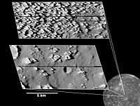
Views of eroding (top) and mostly eroded (bottom) ice knobs (~100 m high), possibly formed from the ejecta of an ancient impact are shown in the second images at left.
"The highest-resolution views ever obtained of any of Jupiter's moons, taken by NASA's Galileo spacecraft in May 2001, reveal numerous bright, sharp knobs covering a portion of Jupiter's moon Callisto."[24]
"The knobby terrain seen throughout the top inset is unlike any seen before on Jupiter's moons. The spires are very icy but also contain some darker dust. As the ice erodes, the dark material apparently slides down and collects in low-lying areas. Over time, as the surface continues to erode, the icy knobs will likely disappear, producing a scene similar to the bottom inset. The number of impact craters in the bottom image indicates that erosion has essentially ceased in the dark plains shown in that image, allowing impact craters to persist and accumulate."[24]
"The knobs are about 80 to 100 meters (260 to 330 feet) tall, and they may consist of material thrown outward from a major impact billions of years ago. The areas captured in the images lie south of Callisto's large Asgard impact basin."[24]
"The smallest features discernable in the images are about 3 meters (10 feet) across."[24]
Atmospheres
"Callisto is surrounded by an extremely thin atmosphere composed of carbon dioxide[15] and probably molecular oxygen,[25] as well as by a rather intense ionosphere.[8]"[3]
"Callisto has a very tenuous atmosphere composed of carbon dioxide.[15] It was detected by the Galileo Near Infrared Mapping Spectrometer (NIMS) from its absorption feature near the wavelength 4.2 micrometers. The surface pressure is estimated to be 7.5 x 10⁻¹² bar (0.75 µPa) and particle density 4 x 108 cm−3. Because such a thin atmosphere would be lost in only about 4 days (see atmospheric escape), it must be constantly replenished, possibly by slow sublimation of carbon dioxide ice from the satellite's icy crust,[15] which would be compatible with the sublimation–degradation hypothesis for the formation of the surface knobs."[3]
"[O]xygen has not yet been directly detected in the atmosphere of Callisto. Observations with the Hubble Space Telescope (HST) placed an upper limit on its possible concentration in the atmosphere, based on lack of detection, which is still compatible with the ionospheric measurements.[26] At the same time HST was able to detect condensed oxygen trapped on the surface of Callisto.[27]"[3]
"Callisto's ionosphere was first detected during Galileo flybys;[8] its high electron density of 7–17 x 104 cm−3 cannot be explained by the photoionization of the atmospheric carbon dioxide alone. Hence, it is suspected that the atmosphere of Callisto is actually dominated by molecular oxygen (in amounts 10–100 times greater than CO2).[25]"[3]
Research
Hypothesis:
- Callisto is a rocky object.
Control groups

The findings demonstrate a statistically systematic change from the status quo or the control group.
“In the design of experiments, treatments [or special properties or characteristics] are applied to [or observed in] experimental units in the treatment group(s).[28] In comparative experiments, members of the complementary group, the control group, receive either no treatment or a standard treatment.[29]"[30]
Proof of concept
Def. a “short and/or incomplete realization of a certain method or idea to demonstrate its feasibility"[31] is called a proof of concept.
Def. evidence that demonstrates that a concept is possible is called proof of concept.
The proof-of-concept structure consists of
- background,
- procedures,
- findings, and
- interpretation.[32]
See also
References
- 1 2 3 Sue Lavoie (October 13, 1998). "PIA01629: Textured Terrain in Callisto's Asgard Basin". Pasadena, California USA: NASA/JPL. Retrieved 2014-06-24.
- ↑ Cooper, John F.; Johnson, Robert E.; Mauk, Barry H.; et al. (2001). "Energetic Ion and Electron Irradiation of the Icy Galilean Satellites" (PDF). Icarus 139 (1): 133–159. doi:10.1006/icar.2000.6498. http://people.virginia.edu/~rej/Icarus_Jan2001_Cooper_et_al.pdf.
- 1 2 3 4 5 6 7 8 9 10 11 12 13 14 15 16 17 18 19 20 21 "Callisto (moon), In: Wikipedia". San Francisco, California: Wikimedia Foundation, Inc. June 10, 2012. Retrieved 2012-07-01.
- 1 2 3 Sue Lavoie (December 18, 1997). "PIA00516: Callisto's Valhalla impact structure". Pasadena, California USA: NASA/JPL. Retrieved 2014-06-24.
- 1 2 3 4 Autumn Burdick (September 22, 2011). "Capturing Callisto". Tucson, Arizona USA: NASA/Johns Hopkins University Applied Physics Laboratory/Southwest Research Institute. Retrieved 2014-06-24.
- ↑ Sue Lavoie (January 9, 1997). "PIA00484: Concentric Rings Surrounding Valhalla". Pasadena, California USA: NASA/JPL. Retrieved 2014-06-24.
- 1 2 3 Autumn Burdick (December 7, 1998). "Callisto Impact Craters". Pasadena, California USA: NASA/JPL. Retrieved 2014-06-24.
- 1 2 3 A. J. Kliore, A. Anabtawi, R. G. Herrera, et al. (2002). "Ionosphere of Callisto from Galileo radio occultation observations". Journal of Geophysics Research 107 (A11): 1407. doi:10.1029/2002JA009365.
- 1 2 3 4 5 6 7 8 9 10 11 12 13 14 15 Moore, Jeffrey M..; Chapman, Clark R.; Bierhaus, Edward B. et al. (2004). "Callisto". Jupiter: The planet, Satellites and Magnetosphere. Ed. Bagenal, F.; Dowling, T.E.; McKinnon, W.B.. Cambridge University Press.
- ↑ Brown, R. H.; Baines, K. H.; Bellucci, G.; et al. (2003). "Observations with the Visual and Infrared Mapping Spectrometer (VIMS) during Cassini's Flyby of Jupiter". Icarus 164 (2): 461–470. doi:10.1016/S0019-1035(03)00134-9.
- ↑ Noll, K.S. (1996). "Detection of SO2 on Callisto with the Hubble Space Telescope" (PDF). Lunar and Planetary Science XXXI. p. 1852.
- ↑ Showman, Adam P.; Malhotra, Renu (1999). "The Galilean Satellites" (PDF). Science 286 (5437): 77–84. doi:10.1126/science.286.5437.77. PMID 10506564. http://www.lpl.arizona.edu/~showman/publications/showman-malhotra-1999.pdf.
- 1 2 3 4 5 6 7 8 9 10 11 12 13 14 15 16 17 Greeley, R.; Klemaszewski, J. E.; Wagner, L.; et al. (2000). "Galileo views of the geology of Callisto". Planetary and Space Science 48 (9): 829–853. doi:10.1016/S0032-0633(00)00050-7.
- ↑ J. Spencer and K. Noll (October 10, 1995). "Hubble Photo Gallery of Jupiter's Galilean Satellites". Baltimore, Maryland USA: Hubble Space Telescope. Retrieved 2014-06-24.
- 1 2 3 4 5 Carlson, R. W.; et al. (1999). "A Tenuous Carbon Dioxide Atmosphere on Jupiter's Moon Callisto" (PDF). Science 283 (5403): 820–821. doi:10.1126/science.283.5403.820. PMID 9933159. http://trs-new.jpl.nasa.gov/dspace/bitstream/2014/16785/1/99-0186.pdf.
- ↑ Hibbitts, C.A.; McCord, T. B.; Hansen, G.B. (1998). "Distributions of CO2 and SO2 on the Surface of Callisto" (PDF). Lunar and Planetary Science XXXI. p. 1908.
- ↑ Zahnle, K.; Dones, L. (1998). "Cratering Rates on the Galilean Satellites" (PDF). Icarus 136 (2): 202–222. doi:10.1006/icar.1998.6015. PMID 11878353. http://lasp.colorado.edu/icymoons/europaclass/Zahnle_etal_1998.pdf.
- 1 2 3 Bender, K. C.; Rice, J. W.; Wilhelms, D. E.; Greeley, R. (1997). Geological map of Callisto. U.S. Geological Survey. http://astrogeology.usgs.gov/Projects/PlanetaryMapping/DIGGEOL/galsats/callisto/jcglobal.htm.
- 1 2 "Controlled Photomosaic Map of Callisto JC 15M CMN" (2002 ed.). U.S. Geological Survey.
- ↑ Klemaszewski, J.A.; Greeley, R. (2001). "Geological Evidence for an Ocean on Callisto" (PDF). Lunar and Planetary Science XXXI. p. 1818.
- ↑ Wagner, R.; Neukum, G.; Greeley, R; et al. (March 12–16, 2001) (PDF). Fractures, Scarps, and Lineaments on Callisto and their Correlation with Surface Degradation. http://www.lpi.usra.edu/meetings/lpsc2001/pdf/1838.pdf.
- 1 2 3 Moore, Jeffrey M.; Asphaug, Erik; Morrison, David; et al. (1999). "Mass Movement and Landform Degradation on the Icy Galilean Satellites: Results of the Galileo Nominal Mission". Icarus 140 (2): 294–312. doi:10.1006/icar.1999.6132.
- 1 2 Sue Lavoie (December 10, 1997). "PIA01095: Landslides on Callisto". Washington, D.C.: NASA's Office of Space Science. Retrieved 2013-06-23.
- 1 2 3 4 Sue Lavoie (August 22, 2001). "PIA03455: Callisto Close-up with Jagged Hills". Washington, D.C.: NASA's Office of Space Science. Retrieved 2013-06-23.
- 1 2 Liang, M. C.; Lane, B. F.; Pappalardo, R. T.; et al. (2005). "Atmosphere of Callisto" (PDF). Journal of Geophysics Research 110 (E2): E02003. doi:10.1029/2004JE002322. http://yly-mac.gps.caltech.edu/ReprintsYLY/N164Liang_Callisto%2005/Liang_callisto_05.pdf.
- ↑ Strobel, Darrell F.; Saur, Joachim; Feldman, Paul D.; et al. (2002). "Hubble Space Telescope Space Telescope Imaging Spectrograph Search for an Atmosphere on Callisto: a Jovian Unipolar Inductor". The Astrophysical Journal 581 (1): L51–L54. doi:10.1086/345803.
- ↑ Spencer, John R.; Calvin, Wendy M. (2002). "Condensed O2 on Europa and Callisto" (PDF). The Astronomical Journal 124 (6): 3400–3403. doi:10.1086/344307. http://www.boulder.swri.edu/~spencer/o2europa.pdf.
- ↑ Klaus Hinkelmann, Oscar Kempthorne (2008). Design and Analysis of Experiments, Volume I: Introduction to Experimental Design (2nd ed.). Wiley. ISBN 978-0-471-72756-9. http://books.google.com/?id=T3wWj2kVYZgC&printsec=frontcover.
- ↑ R. A. Bailey (2008). Design of comparative experiments. Cambridge University Press. ISBN 978-0-521-68357-9. http://www.cambridge.org/uk/catalogue/catalogue.asp?isbn=9780521683579.
- ↑ "Treatment and control groups, In: Wikipedia". San Francisco, California: Wikimedia Foundation, Inc. May 18, 2012. Retrieved 2012-05-31.
- ↑ "proof of concept, In: Wiktionary". San Francisco, California: Wikimedia Foundation, Inc. November 10, 2012. Retrieved 2013-01-13.
- ↑ Ginger Lehrman and Ian B Hogue, Sarah Palmer, Cheryl Jennings, Celsa A Spina, Ann Wiegand, Alan L Landay, Robert W Coombs, Douglas D Richman, John W Mellors, John M Coffin, Ronald J Bosch, David M Margolis (August 13, 2005). "Depletion of latent HIV-1 infection in vivo: a proof-of-concept study". Lancet 366 (9485): 549-55. doi:10.1016/S0140-6736(05)67098-5. http://www.ncbi.nlm.nih.gov/pmc/articles/PMC1894952/. Retrieved 2012-05-09.
External links
- African Journals Online
- Bing Advanced search
- Google Books
- Google scholar Advanced Scholar Search
- International Astronomical Union
- JSTOR
- Lycos search
- NASA/IPAC Extragalactic Database - NED
- NASA's National Space Science Data Center
- Office of Scientific & Technical Information
- PubChem Public Chemical Database
- Questia - The Online Library of Books and Journals
- SAGE journals online
- The SAO/NASA Astrophysics Data System
- Scirus for scientific information only advanced search
- SDSS Quick Look tool: SkyServer
- SIMBAD Astronomical Database
- SIMBAD Web interface, Harvard alternate
- Spacecraft Query at NASA.
- SpringerLink
- Taylor & Francis Online
- Universal coordinate converter
- Wiley Online Library Advanced Search
- Yahoo Advanced Web Search
| |||||||||||||||||||||||||||||||||||
![]() This is a research project at http://en.wikiversity.org
This is a research project at http://en.wikiversity.org
| |
Development status: this resource is experimental in nature. |
| |
Educational level: this is a research resource. |
| |
Resource type: this resource is an article. |
| |
Resource type: this resource contains a lecture or lecture notes. |
| |
Subject classification: this is an astronomy resource. |