Astrogeology
Astrogeology is the study of naturally occurring astronomical rocky objects, their physical structure and substance, history and origin, and the processes that act on them, especially by examination of their rocks.
Earth
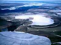
The first image on the right is an aerial image of the ice cap on Ellesmere Island, Canada.
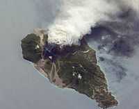
Oblique images such as the one on the second lower right are taken by astronauts looking out from the ISS at an angle, rather than looking straight downward toward the Earth (a perspective called a nadir view), as is common with most remotely sensed data from satellites. An oblique view gives the scene a more three-dimension quality, and provides a look at the vertical structure of the volcanic plume. While much of the island is covered in green vegetation, grey deposits that include pyroclastic flows and volcanic mud-flows (lahars) are visible extending from the volcano toward the coastline. When compared to its extent in earlier views, the volcanic debris has filled in more of the eastern coastline. Urban areas are visible in the northern and western portions of the island; they are recognizable by linear street patterns and the presence of bright building rooftops. The silver-grey appearance of the Caribbean Sea surface is due to sun-glint, which is the mirror-like reflection of sunlight off the water surface back towards the hand-held camera on-board the ISS. The sun-glint highlights surface wave patterns around the island.
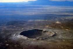
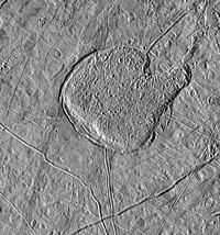
The image on the left is an aerial view of the Barringer Meteor Crater. Fragments of an iron-nickel meteorite have been found in the crater confirming its origin as an impact crater.
Europa

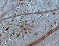
"[T]he darker regions are areas where Europa's primarily water ice surface has a higher mineral content. ... This surface is striated by cracks and streaks, while cratering is relatively infrequent. ... Other features present on Europa are circular and elliptical lenticulae (Latin for "freckles" [reddish spots in the first image at left]). Many are domes, some are pits and some are smooth, dark spots. Others have a jumbled or rough texture. The dome tops look like pieces of the older plains around them, suggesting that the domes formed when the plains were pushed up from below.[1] ... The prominent markings crisscrossing the moon seem to be mainly albedo features, which emphasize low topography."[2]
"Reddish spots and shallow pits pepper the enigmatic ridged surface of Europa in this view combining information from images taken by NASA's Galileo spacecraft during two different orbits around Jupiter."[3]
"The spots and pits visible in this region of Europa's northern hemisphere are each about 10 kilometers (6 miles) across. The dark spots are called "lenticulae," the Latin term for freckles. Their similar sizes and spacing suggest that Europa's icy shell may be churning away like a lava lamp, with warmer ice moving upward from the bottom of the ice shell while colder ice near the surface sinks downward. Other evidence has shown that Europa likely has a deep melted ocean under its icy shell. Ruddy ice erupting onto the surface to form the lenticulae may hold clues to the composition of the ocean and to whether it could support life."[3]
"The image combines higher-resolution information obtained when Galileo flew near Europa on May 31, 1998, during the spacecraft's 15th orbit of Jupiter, with lower-resolution color information obtained on June 28, 1996, during Galileo's first orbit."[3]
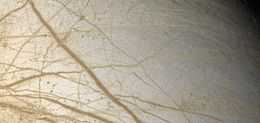
"Europa's most striking surface features are a series of dark streaks crisscrossing the entire globe, called lineae (lines). Close examination shows that the edges of Europa's crust on either side of the cracks have moved relative to each other. The larger bands are more than 20 km (12 mi) across, often with dark, diffuse outer edges, regular striations, and a central band of lighter material.[4]"[2]
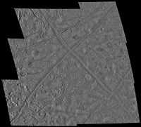
The third image at the right is a "view of the Conamara Chaos region on Jupiter's moon Europa taken by NASA's Galileo spacecraft shows an area where the icy surface has been broken into many separate plates that have moved laterally and rotated. These plates are surrounded by a topographically lower matrix. This matrix material may have been emplaced as water, slush, or warm flowing ice, which rose up from below the surface. One of the plates is seen as a flat, lineated area in the upper portion of the image. Below this plate, a tall twin-peaked mountain of ice rises from the matrix to a height of more than 250 meters (800 feet). The matrix in this area appears to consist of a jumble of many different sized chunks of ice. Though the matrix may have consisted of a loose jumble of ice blocks while it was forming, the large fracture running vertically along the left side of the image shows that the matrix later became a hardened crust, and is frozen today. The Brooklyn Bridge in New York City would be just large enough to span this fracture."[5]
"North is to the top right of the picture, and the sun illuminates the surface from the east. This image, centered at approximately 8 degrees north latitude and 274 degrees west longitude, covers an area approximately 4 kilometers by 7 kilometers (2.5 miles by 4 miles). The resolution is 9 meters (30 feet) per picture element. This image was taken on December 16, 1997 at a range of 900 kilometers (540 miles) by Galileo's solid state imaging system."[5]
"This view [third down on the left] of Jupiter's icy moon Europa shows a region shaped like a mitten that has a texture similar to the matrix of chaotic terrain, which is seen in medium and high resolution images of numerous locations across Europa's surface. Development of such terrain may be one of the major processes for resurfacing the moon. North is to the top and the sun illuminates the surface from the left. The material in the "catcher's mitt" has the appearance of frozen slush and seems to bulge upward from the adjacent surface, which has been bent downward and cracked, especially along the southwest (lower left) margins. Scientists on the Galileo imaging team are exploring various hypotheses for the formation of such terrain including solid-state convection (vertical movement between areas which differ in density due to heating), upwelling of viscous icy "lava," or liquid water melting through from a subsurface ocean."[6]
"The image, centered at 20 degrees north latitude, 80 degrees west longitude covers an area approximately 175 by 180 kilometers (108 by 112 miles). The resolution is 235 meters per picture element. The images were taken on 31 May, 1998 Universal Time at a range of 23 thousand kilometers (14 thousand miles) by the Solid State Imaging (SSI) system on NASA's Galileo spacecraft."[6]
Ganymede
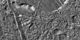
"NASA's Galileo spacecraft took this image of dark terrain within Nicholson Regio, near the border with Harpagia Sulcus on Jupiter's moon Ganymede. The ancient, heavily cratered dark terrain is faulted by a series of scarps."[7]
"The faulted blocks form a series of "stair-steps" like a tilted stack of books. On Earth, similar types of features form when tectonic faulting breaks the crust and the intervening blocks are pulled apart and rotate. This image supports the notion that the boundary between bright and dark terrain is created by that type of extensional faulting."[7]
"North is to the right of the picture and the Sun illuminates the surface from the west (top). The image is centered at -14 degrees latitude and 320 degrees longitude, and covers an area approximately 16 by 15 kilometers (10 by 9 miles). The resolution is 20 meters (66 feet) per picture element. The image was taken on May 20, 2000, at a range of 2,090 kilometers (1,299 miles)."[7]
Research
Hypothesis:
- Geological forces found on Earth should be applicable to astronomical objects consisting of rocks.
Control groups

The findings demonstrate a statistically systematic change from the status quo or the control group.
“In the design of experiments, treatments [or special properties or characteristics] are applied to [or observed in] experimental units in the treatment group(s).[8] In comparative experiments, members of the complementary group, the control group, receive either no treatment or a standard treatment.[9]"[10]
Proof of concept
Def. a “short and/or incomplete realization of a certain method or idea to demonstrate its feasibility"[11] is called a proof of concept.
Def. evidence that demonstrates that a concept is possible is called proof of concept.
The proof-of-concept structure consists of
- background,
- procedures,
- findings, and
- interpretation.[12]
See also
References
- ↑ Sotin, Christophe; Head III, James W.; and Tobie, Gabriel (2001). "Europa: Tidal heating of upwelling thermal plumes and the origin of lenticulae and chaos melting" (PDF). Retrieved 2007-12-20.
- 1 2 "Europa (moon), In: Wikipedia". San Francisco, California: Wikimedia Foundation, Inc. June 22, 2013. Retrieved 2013-06-24.
- 1 2 3 Sue Lavoie (October 30, 2002). "PIA03878: Ruddy "Freckles" on Europa". Washington, D.C. USA: NASA's Office of Space Science. Retrieved 2013-06-24.
- ↑ Geissler, Paul E.; Greenberg, Richard; et al. (1998). "Evolution of Lineaments on Europa: Clues from Galileo Multispectral Imaging Observations". Retrieved 2007-12-20.
- 1 2 Sue Lavoie (March 02, 1998). "PIA01177: Chaotic Terrain on Europa in Very High Resolution". Washington, DC USA: NASA's Office of Space Science. Retrieved 2013-06-24.
- 1 2 Sue Lavoie (October 13, 1998). "PIA01640: Mitten shaped region of Chaotic Terrain on Europa". Washington, DC USA: NASA's Office of Space Science. Retrieved 2013-06-24.
- 1 2 3 Autumn Burdick (December 16, 2000). "PIA02582: Stair-step Scarps in Dark Terrain on Ganymede". Pasadena, California USA: NASA/JPL. Retrieved 2014-06-12.
- ↑ Klaus Hinkelmann, Oscar Kempthorne (2008). Design and Analysis of Experiments, Volume I: Introduction to Experimental Design (2nd ed.). Wiley. ISBN 978-0-471-72756-9. http://books.google.com/?id=T3wWj2kVYZgC&printsec=frontcover.
- ↑ R. A. Bailey (2008). Design of comparative experiments. Cambridge University Press. ISBN 978-0-521-68357-9. http://www.cambridge.org/uk/catalogue/catalogue.asp?isbn=9780521683579.
- ↑ "Treatment and control groups, In: Wikipedia". San Francisco, California: Wikimedia Foundation, Inc. May 18, 2012. Retrieved 2012-05-31.
- ↑ "proof of concept, In: Wiktionary". San Francisco, California: Wikimedia Foundation, Inc. November 10, 2012. Retrieved 2013-01-13.
- ↑ Ginger Lehrman and Ian B Hogue, Sarah Palmer, Cheryl Jennings, Celsa A Spina, Ann Wiegand, Alan L Landay, Robert W Coombs, Douglas D Richman, John W Mellors, John M Coffin, Ronald J Bosch, David M Margolis (August 13, 2005). "Depletion of latent HIV-1 infection in vivo: a proof-of-concept study". Lancet 366 (9485): 549-55. doi:10.1016/S0140-6736(05)67098-5. http://www.ncbi.nlm.nih.gov/pmc/articles/PMC1894952/. Retrieved 2012-05-09.
Further reading
- Autumn Burdick (December 16, 2000). "PIA02582: Stair-step Scarps in Dark Terrain on Ganymede". Pasadena, California USA: NASA/JPL. Retrieved 2014-06-12.
External links
- African Journals Online
- Bing Advanced search
- Google Books
- Google scholar Advanced Scholar Search
- International Astronomical Union
- JSTOR
- Lycos search
- NASA/IPAC Extragalactic Database - NED
- NASA's National Space Science Data Center
- Office of Scientific & Technical Information
- PubChem Public Chemical Database
- Questia - The Online Library of Books and Journals
- SAGE journals online
- The SAO/NASA Astrophysics Data System
- Scirus for scientific information only advanced search
- SDSS Quick Look tool: SkyServer
- SIMBAD Astronomical Database
- SIMBAD Web interface, Harvard alternate
- Spacecraft Query at NASA.
- SpringerLink
- Taylor & Francis Online
- Universal coordinate converter
- Wiley Online Library Advanced Search
- Yahoo Advanced Web Search
| |||||||||||||||||||||||||||||||||||
| ||||||||||||||||||||||||||||||||||||||
![]() This is a research project at http://en.wikiversity.org
This is a research project at http://en.wikiversity.org
| |
Educational level: this is a research resource. |
| |
Resource type: this resource is an article. |
| |
Resource type: this resource contains a lecture or lecture notes. |
| |
Subject classification: this is an astronomy resource. |
| |
Subject classification: this is an astrophysics resource. |
| |
Subject classification: this is a Geology resource. |