Wikijunior:North America/United States/Maryland
< Wikijunior:North America < United States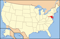
The location of Maryland.
Maryland is a state located in the Mid Atlantic region of the United States, bordering Virginia, West Virginia and the District of Columbia to the south and west, Pennsylvania to the north, and Delaware to the east. It is comparable in size to the European country of Belgium.

The Flag of Maryland
Geography
Maryland is made up of 23 counties and the City of Baltimore. Included in its boundaries is the Chesapeake Bay, which is one of the most productive estuaries in the world. On the eastern edge of the state is the Atlantic Ocean.
People
- Spiro Agnew, former Vice President of the United States
- Clara Barton, founder of the American Red Cross
- Cal Ripken Jr, baseball player
- Babe Ruth, baseball player
State Symbols
- Bird = Baltimore Oriole
- Dessert = Smith Island Cake
- Exercise= Walking
- Tree = White Oak
This article is issued from Wikibooks. The text is licensed under Creative Commons - Attribution - Sharealike. Additional terms may apply for the media files.